
Blizzard Warnings Expand From Delaware to Connecticut as High-Impact Nor’easter Targets NYC, Long Island and Boston With 13–18 Inches and 55 MPH Gusts
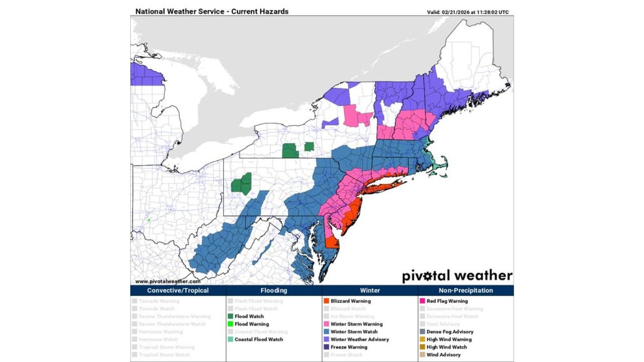
UPPER ATLANTIC COAST — A high-impact winter storm is set to slam the upper Atlantic coastal region from Sunday through Monday, with blizzard warnings now in effect for coastal portions of Delaware, New Jersey, New York, and Connecticut. Officials indicate those warnings may soon expand into coastal Rhode Island and eastern Massachusetts.
Forecasters warn this system will rapidly intensify offshore, bringing heavy snowfall, powerful wind gusts up to 55 mph, and widespread travel disruptions across the Northeast.
13–18 Inches in Blizzard Warning Zones
In areas currently under blizzard warnings — including Long Island, New York City, coastal New Jersey, and coastal Connecticut — snowfall totals between 13 and 18 inches are expected.
Localized amounts could exceed that range in persistent heavy snow bands, especially across:
- New York City
- Long Island (including Nassau and Suffolk Counties)
- Southern Connecticut from Stamford to New Haven and New London
- Coastal New Jersey communities
Ensemble snowfall projections through Tuesday show a swath of double-digit totals hugging the coastline, with some guidance suggesting pockets above 18 inches in parts of Long Island and southern New England.
Winds Up to 55 MPH Could Create Blizzard Conditions
Wind gusts as high as 55 mph are possible near the coast. Combined with heavy snowfall rates, this could produce:
- Whiteout conditions
- Blowing and drifting snow
- Near-zero visibility at times
- Increased risk of scattered power outages
Blizzard conditions are most likely in coastal communities where strong onshore flow coincides with peak snowfall.
Major Travel Disruptions Expected
The storm is expected to severely disrupt travel and airport operations in major metro areas, including:
- Philadelphia
- New York City
- Boston
Heavy snow and strong crosswinds could lead to flight cancellations and significant roadway impacts late Sunday into Monday.
Snow Extending Into Baltimore and Washington
While the most extreme impacts are expected from coastal Delaware northward, accumulating snow is also likely in:
- Baltimore
- Washington, D.C.
- Parts of interior Pennsylvania and New Jersey
These areas may see moderate snowfall totals, though generally lower than those under blizzard warnings.
Coastal Flooding and Marine Impacts
In addition to snow and wind, minor to moderate coastal flooding is possible during high tide cycles from Sunday night into Monday morning. Localized dune erosion and ocean overwash may occur along vulnerable shorelines.
Gale to storm-force conditions and high seas are also expected over coastal waters.
Bottom Line
A significant nor’easter will bring blizzard warnings, 13–18 inches of snow, and wind gusts up to 55 mph from Delaware through New York and Connecticut, with impacts potentially expanding into Rhode Island and eastern Massachusetts.
Major disruptions to travel, airports, and daily life are expected across the I-95 corridor, especially in Philadelphia, New York City, and Boston.
Residents should finalize preparations and monitor official updates as this powerful coastal storm unfolds.
Stay with Waldronnews.com for continuing updates.