
GFS Paints 15–20+ Inch Snow Swath Across Pennsylvania, New York, Massachusetts and Connecticut for March 2–3 — But Model Disagreement Clouds Forecast
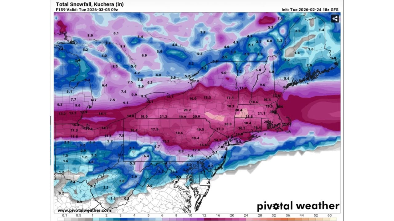
UNITED STATES — A new model run is intensifying the snowfall conversation for the Northeast, with the latest 18z GFS Kuchera output projecting a significant band of heavy snow from Pennsylvania through New York and into southern New England for Monday into early Tuesday, March 2–3, 2026. However, forecasters caution that not all global models agree, adding uncertainty to the developing setup.
The newest guidance suggests the potential for a high-impact winter storm — but confidence remains far from locked in.
GFS Projects Widespread 15–20+ Inch Totals
According to the 18z GFS Kuchera snowfall projection valid early Tuesday morning (March 3), a broad corridor of heavy accumulation stretches across:
- Central and eastern Pennsylvania
- Southern and central New York
- Northern New Jersey
- Western and central Massachusetts
- Connecticut
- Rhode Island
Within that corridor, projected totals reach:
- 15 to 18 inches across large portions of Pennsylvania and New York
- 18 to 21 inches in localized areas of upstate New York and western Massachusetts
- Around 16 to 20 inches across interior Connecticut and parts of northern New Jersey
Some isolated pockets in eastern Pennsylvania and southern New York show totals exceeding 20 inches in this model run.
Sharp Northern and Southern Cutoffs
North of the heaviest band, snowfall projections drop off considerably across:
- Northern New York
- Northern Vermont
- Northern New Hampshire
- Interior Maine
These areas generally show lighter totals, ranging from 2 to 6 inches in many locations.
To the south, totals taper quickly across:
- Southern New Jersey
- Delaware
- Maryland
- Northern Virginia
Here, projected amounts range from a coating to several inches, with sharper gradients near the rain-snow line.
This sharp cutoff indicates a narrow but intense deformation band in the GFS solution — a hallmark of dynamic winter systems.
New York City and Boston in the Heavy Band
The model places major metropolitan areas near or within the heavier snow zone, including:
- New York City
- Hartford
- Providence
- Boston
If the GFS verifies, travel disruptions could be substantial during the Monday–Tuesday timeframe, particularly for early-week commuters.
However, slight storm track adjustments could shift this heavy band north or south by dozens of miles — significantly altering snowfall totals in urban corridors.
Model Disagreement Adds Uncertainty
While the 18z GFS run depicts a robust snowfall event, other guidance — including the 12z European model — does not align as closely with this aggressive solution.
Such disagreement at this range suggests:
- Track uncertainty
- Temperature profile variability
- Potential precipitation type shifts
This is especially critical along the I-95 corridor, where marginal temperatures could lead to mixing or reduced totals if warmer air intrudes.
Timing and Impacts
The projected timing centers on Monday into early Tuesday, March 2–3.
If heavy snow bands develop during peak travel hours, impacts could include:
- Hazardous road conditions
- Flight delays
- School and business disruptions
Interior elevations and colder inland areas appear most favored for significant accumulation at this time.
Bottom Line: Significant Potential, But Not Locked In
The latest GFS run certainly raises eyebrows with widespread 15–20+ inch totals across Pennsylvania, New York and southern New England. However, given ongoing model disagreement, this remains a system that requires close monitoring rather than immediate conclusions.
Forecast clarity should improve over the next several model cycles as storm track and thermal profiles become better resolved.
Stay with WaldronNews.com for continuing updates as we monitor whether this early-March winter threat becomes a major snow event — or shifts in a different direction.