
Severe Thunderstorm Slams Daytona International Speedway Saturday Evening With 2 Inch Hail, 406 Lightning Strikes and Brief Tornado Possible as Rockville Crowd Seeks Shelter
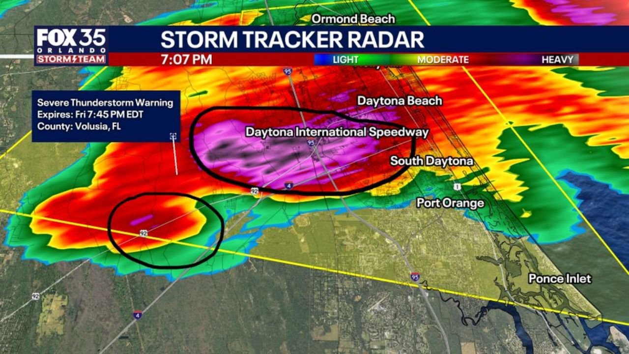
DAYTONA BEACH, Florida — A very severe thunderstorm slammed Daytona International Speedway at 7:07 PM Saturday May 9, 2026, producing quarter to ping pong ball size hail, 406 total lightning strikes and rotation indicating a brief tornado is possible within the storm. A Severe Thunderstorm Warning for Volusia County was active expiring at 7:45 PM EDT as the storm moved directly over the Speedway where the Rockville music festival was underway.
What the Storm Is Producing at 7:07 PM
Hail Detector readings at 7:08 PM:
- 2 inches — west of the Speedway in the core of the storm
- 1.75 inches — approaching the Speedway from the northwest
- 1 inch — southwest fringe of the hail swath
- .75 inches — directly over Daytona International Speedway
Lightning: 406 total strikes across the storm — an extremely high lightning density making outdoor exposure immediately life-threatening
Rotation: A separate smaller circulation circled on radar southwest of the Speedway indicating a brief tornado is possible with this storm
Active Warning Details
- Warning type: Severe Thunderstorm Warning
- County: Volusia, Florida
- Expires: 7:45 PM EDT Friday
- The large black oval on radar encompasses the full Daytona International Speedway and surrounding Daytona Beach area within the warning polygon
Radar Situation at 7:07 PM
- Purple and deep red cores sitting directly over Daytona International Speedway — the most intense radar returns indicating the heaviest rain and largest hail concentrated over the venue
- A second intense cell circled separately southwest of the Speedway showing rotation — this is the cell where a brief tornado cannot be ruled out
- 406 lightning strikes visible across the entire storm complex from Holly Hill through Daytona Beach, Port Orange and toward Ponce Inlet
- Severe Thunderstorm Warning polygon covers Daytona Beach, South Daytona, Daytona International Speedway and the surrounding Volusia County corridor
What Rockville Attendees Must Do Right Now
- Get inside a permanent structure immediately — 406 lightning strikes make any outdoor location immediately dangerous regardless of how far away the nearest strike appears
- Do not shelter under trees, in open fields or in tents — none of these provide protection from lightning or large hail
- Hail up to 2 inches can cause serious injury to anyone caught outdoors — cover your head and get inside
- A brief tornado is possible with the rotating cell southwest of the Speedway — treat this as an immediate tornado threat until the warning expires
- The warning expires at 7:45 PM but conditions may remain dangerous after expiration — wait for an all-clear from event staff before returning to open areas
WaldronNews.com will continue tracking this severe thunderstorm over Daytona Beach and Daytona International Speedway and will provide immediate updates as the storm moves through and any tornado warnings are issued.