
Mississippi EF3 Tornado Confirmed at 65 Miles Long and 140 mph From Meadville to Monticello With 13 Injuries as Massive Wedge Stayed on the Ground Through Brookhaven
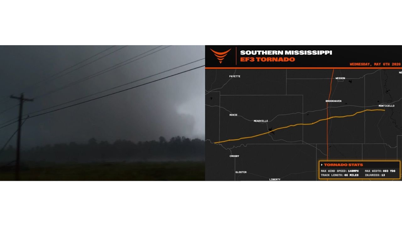
BROOKHAVEN, Mississippi — The National Weather Service Jackson has confirmed a single long-track EF3 tornado traveled 65 miles across southern Mississippi on Wednesday May 6, 2026, with maximum winds of 140 mph, a maximum width of 683 yards and 13 injuries reported along the path. What appeared on radar as two separate tornadoes was actually one continuous tornado that underwent a failed cycle midway through its track before reinvigorating for the second half of its path — a behavior that made it one of the most significant tornadoes to strike Mississippi in recent years.
Official EF3 Tornado Statistics
- Rating: EF3
- Maximum wind speed: 140 mph
- Track length: 65 miles
- Maximum width: 683 yards
- Injuries: 13
- Fatalities: 0
- Date: Wednesday May 6, 2026
The Full Path From West to East
The confirmed track stretches in a nearly straight line from southwest to northeast across Franklin and Lincoln counties:
- Origin: Southwest of Meadville and Crosby in Franklin County — the tornado touched down in a rural forested corridor
- Through Meadville — the wedge was observed from birth in this area at 7:40 PM
- Crossing through Roxie and the Homochitto National Forest corridor
- Through Brookhaven — the most populated area along the entire track where the PDS tornado warning was active
- Continuing northeast through Wesson
- Final touchdown near Monticello in Lawrence County where the tornado finally lifted after 65 miles on the ground
What Made This Tornado Unusual
Storm observers watched the massive wedge from birth and tracked it continuously through its entire 65-mile path. At some point during the track, radar showed what appeared to be a failed mesocyclone cycle — a process where the rotating updraft briefly weakens and appears to be dying. Instead of lifting, the tornado reinvigorated for the second half of its path, producing the same or greater intensity through Brookhaven and beyond. This behavior is why preliminary data suggested two separate tornadoes — the brief weakening during the cycle created a gap in the damage path that looked like two distinct events until ground surveys connected the full track.
Why 13 Injuries and Zero Fatalities With a 65-Mile EF3
The Particularly Dangerous Situation tornado warning issued by the National Weather Service gave residents along the path advance notice well beyond a standard tornado warning. The PDS designation is reserved for the most dangerous tornado situations and communicates urgency that standard warnings do not. Combined with the Tornado Watch already in effect for the region, residents had multiple warning layers before the wedge arrived. The 13 injuries along a 65-mile EF3 track through populated areas including Brookhaven represents an extraordinary outcome given the storm’s intensity and duration.
What a 683-Yard-Wide EF3 Looks Like on the Ground
A tornado 683 yards wide covers nearly two-fifths of a mile from edge to edge at its widest point. At EF3 intensity with 140 mph winds, everything within that width faces catastrophic structural damage. Well-built homes lose exterior walls and roofs. Trees are completely debarked with only stubs of the largest branches remaining — the exact damage description surveyors used to assign the EF3 rating across portions of the Franklin County track where mobile homes and tree damage were the primary available indicators.
What to Watch as Surveys Continue
- The 65-mile confirmed track may be refined as additional ground survey teams complete their assessments across the full Franklin to Lawrence county corridor
- The 13 injury count is preliminary and may be updated as damage assessment continues across rural portions of the track
- Additional tornadoes from the same Wednesday outbreak including the shorter EF0 and EF1 tornadoes near Hattiesburg and Purvis are still being assessed separately
- The preliminary EF4 radar estimate for the Franklin County storm from Wednesday night may now be reconciled against the confirmed EF3 ground survey — the difference likely reflects the mobile home and tree-damage limitation on assigning higher ratings
WaldronNews.com will continue tracking damage survey updates from the May 6 southern Mississippi EF3 tornado and will provide updates as the National Weather Service Jackson completes its full assessment across the 65-mile track.