
Active Storm Pattern Building Across Central U.S. Into Midwest as Heavy Rain Signal Grows, SPC Flags 15% Severe Risk in Southern Plains
UNITED STATES — Weather models are signaling a noticeable shift toward a more active pattern over the next couple of weeks, with widespread precipitation expected from the central United States into parts of the Midwest and Ohio Valley. At the same time, the Storm Prediction Center (SPC) has introduced a Day 6 severe weather risk area, highlighting growing concern for parts of the southern Plains.
The combination of increasing moisture, strengthening storm tracks, and broad precipitation signals suggests a busier stretch of weather as March begins.
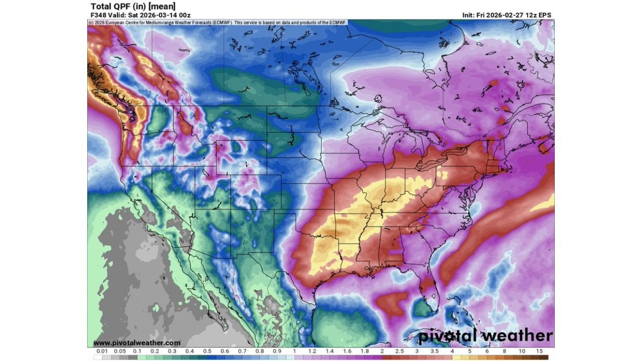
Heavy Precipitation Signal From the Southern Plains to the Ohio Valley
The ensemble mean precipitation map valid through mid-March shows a pronounced swath of heavier rainfall extending from:
- Texas and Oklahoma
- Across Arkansas
- Into Louisiana and Mississippi
- Northeast through Tennessee and Kentucky
- Reaching into parts of the Ohio Valley and Mid-Atlantic
Much of this corridor is shaded in yellow to orange tones, indicating multi-inch rainfall totals are possible in some areas. The most concentrated precipitation axis appears centered from eastern Texas through Arkansas and into western Tennessee and Kentucky.
Farther north, parts of the Midwest and Great Lakes region also show healthy precipitation totals, though generally lighter than areas farther south.
Meanwhile, portions of the West Coast — particularly the Pacific Northwest — also display notable precipitation signals, while the Southwest appears comparatively drier.
SPC Issues Day 6 15% Severe Risk for Southern Plains
Adding to the concern, the Storm Prediction Center’s Day 6 outlook highlights a 15% probability area over parts of:
- North Texas
- Southern Oklahoma
- Possibly extending toward western Arkansas
A 15% risk at six days out is notable and signals increasing confidence in at least some organized severe weather potential.
While exact hazards remain uncertain this far in advance, setups like this often support:
- Strong to severe thunderstorms
- Damaging winds
- Large hail
- Isolated tornado potential
Details will become clearer as higher-resolution guidance comes into range, but the early signal points to a potentially active severe weather episode in the southern Plains region.
Central U.S. Entering a More Energetic Pattern
Ensemble outputs suggest the jet stream will become more amplified, allowing repeated storm systems to track from the Southwest into the Plains and then northeastward into the Midwest and Ohio Valley.
This pattern favors:
- Repeated rounds of rainfall
- Potential flooding concerns where storms train
- Increasing thunderstorm activity across the southern tier
The broad coverage of precipitation across multiple states indicates this won’t be a one-off event, but rather part of a multi-system stretch.
What It Means Going Forward
For the central and southern Plains, attention will turn toward severe weather monitoring as the Day 6 window approaches. For the Midwest and Ohio Valley, heavy rainfall and possible localized flooding may become the bigger concern depending on how storm tracks evolve.
Residents across Texas, Oklahoma, Arkansas, Louisiana, Mississippi, Tennessee, Kentucky, and surrounding states should monitor forecast updates closely as confidence increases.
As the pattern turns more active heading deeper into early March, additional severe and heavy rain signals could emerge.
Stay with WaldronNews.com for continued updates as this evolving storm pattern develops and impacts communities across the central United States.