
Light Snow Band to Brush I-66 Corridor From Washington DC Through Southern Maryland Monday, With Freezing Rain Risk Early Tuesday
UNITED STATES — Forecast models are now aligning on a narrow band of light snow crossing the Mid-Atlantic Monday afternoon, primarily along and near the I-66 corridor from northern Virginia through Washington, DC and into southern Maryland.
Both the European (ECMWF) and NAM 3km models now show similar placement of the snow band, increasing confidence in at least minor wintry impacts before a separate freezing rain concern develops Tuesday morning.
Snow Band Focused Near Washington, DC
Model projections for Monday, March 2 indicate a swath of light snow developing west of the Blue Ridge and pushing eastward toward:
- Charlottesville, VA
- Washington, DC
- Baltimore, MD
- Southern Maryland near Salisbury
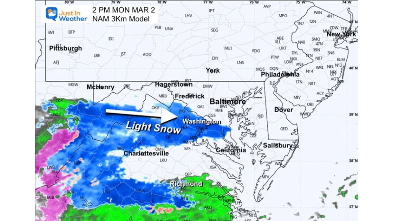
The ECMWF places a narrow light snow zone crossing near I-66 during the mid-to-late afternoon hours. The NAM 3km model shows a similar corridor, with snow moving from western Virginia into DC and then sliding toward southern Maryland by evening.
Timing from the high-resolution NAM suggests:
- Around 2 PM Monday: Snow approaching DC from the west
- Around 4 PM Monday: Light snow crossing Washington and Baltimore
- Around 8 PM Monday: Snow shifting toward southern Maryland and the lower Eastern Shore
Minimal Accumulation Expected for Most
While models agree on the presence of snow, this does not appear to be a high-impact event.
Key points:
- Surface temperatures near or just above freezing in metro areas
- Marginal thermal profiles limiting accumulation
- Snow likely light in intensity
Most lower elevations near DC, Baltimore, and Richmond may see only a coating on grassy surfaces, if that.
However, higher terrain across western Virginia and parts of West Virginia could see slightly better stickage due to colder surface temperatures and elevation effects.
Cold High to the North
A 1039mb high centered offshore of New York keeps cold air in place across parts of the region. This shallow cold layer supports snow as precipitation moves in, but the limited moisture and marginal temperatures prevent significant buildup in urban corridors.
Farther south near Richmond and coastal Virginia, precipitation trends more toward rain or a rain/snow mix.
Freezing Rain Concern Early Tuesday
Attention then turns to Tuesday morning, when light freezing rain remains possible.
With cold air still lingering near the surface and warmer air potentially overriding aloft, light glaze formation could occur in spots — especially inland areas that struggle to warm above freezing.
Even light icing can create slick bridges and untreated roads during the early commute window.
What to Expect Overall
This is not shaping up to be a major winter storm. Instead:
- Monday afternoon: Brief band of light snow
- Minimal accumulations in urban areas
- Slightly better chances in higher elevations
- Early Tuesday: Light freezing rain possible in spots
Residents along I-66, through Washington DC, Baltimore, and into southern Maryland should monitor updates but widespread travel disruptions are not currently expected.
For continued updates on this evolving Mid-Atlantic winter setup and other developing weather stories nationwide, stay with WaldronNews.com for the latest forecast analysis and reporting.