
Winter Weather Advisory Extended North Across Southwest and Central Ohio as Snow and Light Ice Threaten Monday Morning Commute
OHIO — The National Weather Service in Wilmington has extended a Winter Weather Advisory northward, warning that snow and light ice will create slick and hazardous road conditions from 3:00 AM to 11:00 AM Monday.
The advisory covers much of southwest and central Ohio, including major travel corridors near Cincinnati, Dayton, Wilmington, Chillicothe, and Columbus, with impacts expected during the Monday morning commute.
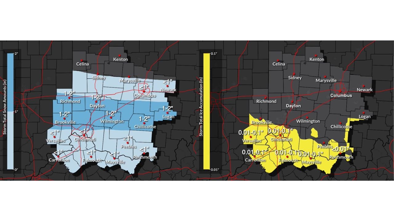
Snow Totals: 1–2 Inches Across Central and Southwest Ohio
Storm total snowfall projections valid from 1:00 AM to 1:00 PM Monday show:
- 1–2 inches from Richmond and Dayton through Wilmington and Chillicothe
- Around 1–2 inches near Logan
- Lighter totals closer to Columbus and Newark, generally near or under 1 inch
- Less than 1 inch south of Cincinnati into northern Kentucky
The steadiest snow band appears to focus between Dayton, Wilmington, and Chillicothe, with Cincinnati on the southern edge of more modest accumulations.
Ice Accumulation: Light but Impactful
In addition to snowfall, light ice accumulation is expected primarily across southern counties.
Forecast ice totals show:
- 0.01 to 0.10 inches near Cincinnati
- Similar light glaze amounts across Versailles, Brookville, Falmouth, Maysville, and Portsmouth
- Pockets of light icing near Peebles and Carrollton
While ice totals appear light, even a few hundredths of an inch can create dangerous travel conditions — especially on untreated roads, bridges, and elevated surfaces.
Greatest Travel Concern: Early Monday Morning
The advisory window of 3 AM to 11 AM Monday directly overlaps the morning commute.
Roads are expected to become:
- Snow-covered in central Ohio counties
- Slushy or icy in southern areas
- Especially slick on bridges and overpasses
Temperatures near or below freezing will allow snow and ice to accumulate before conditions gradually improve later in the day.
Cities in the Advisory Area
The advisory includes communities such as:
- Cincinnati
- Dayton
- Wilmington
- Chillicothe
- Logan
- Versailles
- Brookville
- Portsmouth
- Peebles
- Carrollton
Columbus sits near the northern edge of heavier snow totals, with lighter accumulations expected there compared to areas farther south and west.
What Residents Should Expect
Even though this is not a major winter storm, the combination of:
- 1–2 inches of snow
- Light ice accumulation
- Early-morning timing
Will likely result in slippery roadways and slower travel Monday morning.
Drivers should plan extra travel time, reduce speeds, and be cautious on untreated surfaces.
For continued updates on this developing winter weather event and other major weather alerts nationwide, stay with WaldronNews.com for the latest advisories and forecast analysis.