
Virginia, Maryland, North Carolina and Washington D.C. Could See First 70° Day Since November, But Backdoor Cold Front May Disrupt Mid-Atlantic Warmup
UNITED STATES — A surge of early-March warmth is targeting the Mid-Atlantic, with Thursday shaping up as the first real opportunity since November for temperatures to climb above 70°F across parts of Virginia, Maryland, North Carolina, and Washington D.C.
However, confidence is lower than usual due to the threat of a backdoor cold front that could undercut afternoon highs and dramatically change conditions in a short period of time.
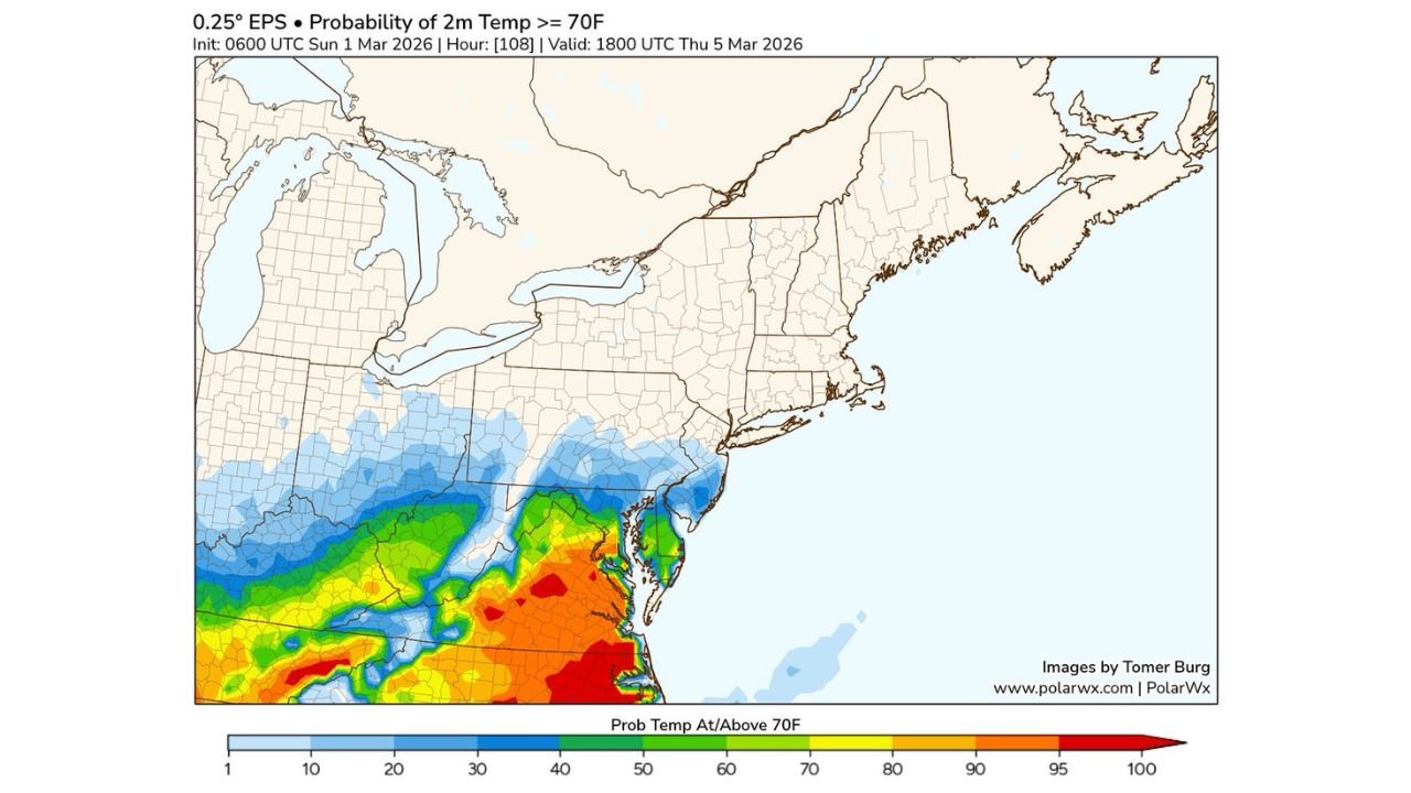
Highest 70° Probabilities Focused on the Mid-Atlantic
The latest ensemble probability data valid Thursday, March 5, 2026, highlights the strongest chances for 70° readings across:
- Central and eastern Virginia
- Southern Maryland
- Washington D.C. metro
- Northeastern North Carolina
These areas show moderate to high probabilities — in some spots exceeding 60–80% — of reaching or exceeding 70°F.
The warmth appears most robust across southern Virginia into northeastern North Carolina, where the deepest orange and red shading suggests the highest confidence in spring-like temperatures.
Northern Areas Face Lower Confidence
Farther north, including:
- Pennsylvania
- New Jersey
- Delaware
- Southern Ohio
- Western West Virginia
probabilities decrease significantly.
This gradient signals how sensitive the setup is to frontal positioning. A slight southward shift in cooler air could keep some cities from reaching the 70° mark altogether.
Backdoor Cold Front the Key Wildcard
Forecasters are cautioning that this is not a straightforward warm surge.
A backdoor cold front — cooler air sliding southwestward from the Northeast and Atlantic — could:
- Cap daytime highs
- Create sharp temperature contrasts over short distances
- Shift winds quickly
- Increase low-level moisture
If the front pushes farther south than expected, some locations currently favored to hit 70° may struggle to reach the upper 60s instead.
Humidity on the Rise
Another notable feature of this pattern is the potential for unusually humid conditions for early March.
Even if thunderstorm chances remain low, higher dew points may make the air feel more like late April than early March in the warmest zones.
What This Means for Arkansas
While the Mid-Atlantic sees this 70° opportunity, Arkansas remains outside the core of this specific warm corridor.
Waldron and surrounding western Arkansas communities are not in the highlighted probability zone for 70° on this particular setup. However, broader national patterns show warmth expanding across large portions of the country this month.
For Arkansas residents, this serves as a reminder of how dynamic March patterns can be — with strong regional contrasts across the United States.
Bottom Line
- Best chance for 70°: Virginia, Maryland, Washington D.C., northeastern North Carolina
- Lower confidence north of that corridor
- Backdoor cold front could alter highs quickly
- Humidity may increase despite limited thunder risk
This is a classic early-spring setup where small shifts in frontal placement make a big difference in outcomes.
For continued updates on evolving March weather patterns and how national systems may influence Arkansas conditions, stay with WaldronNews.com for the latest forecast coverage and regional analysis.