
Colorado Rockies to Pick Up 2–6 Inches of Snow North of I-70 as Mountain Snow Returns Monday Night Into Wednesday Morning
DENVER, COLORADO — Snow is set to redevelop across the Colorado mountains beginning Monday night, with accumulating snowfall likely through Wednesday morning, particularly north of the Interstate 70 corridor.
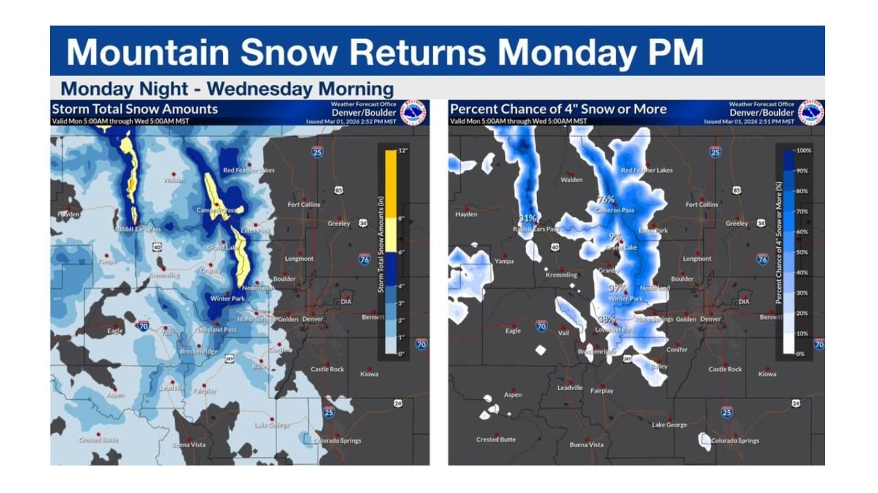
According to the latest forecast data, snow showers will first develop in the higher elevations Monday evening, before rain spreads into lower elevations Tuesday. However, most of the meaningful snow accumulation is expected to remain confined to the northern mountains.
2–6 Inches Possible in Northern Mountains
Forecast totals show a swath of accumulating snow stretching across:
- Cameron Pass
- Rabbit Ears Pass
- Grand Lake
- Winter Park
- Nederland
- Portions of the Front Range foothills
Within these areas — especially north of I-70 — totals of 2 to 6 inches of new snow are possible by Wednesday morning.
Higher elevations along the Continental Divide appear most favored for the stronger totals.
I-70 Corridor Marks the Snow Gradient
Interstate 70 serves as a key dividing line in this event.
- North of I-70: Better chances for steady mountain snow and moderate accumulations.
- Along and south of I-70: Lighter snowfall amounts expected, with some areas seeing minimal accumulation.
Lower elevations, including portions of the Denver metro area, are more likely to see rain or a rain-snow mix rather than impactful snowfall.
4-Inch Probability Focused on Northern Passes
Probability guidance shows the highest chances of seeing at least 4 inches of snow centered near:
- Cameron Pass
- Rabbit Ears Pass
- Higher elevations west of Fort Collins
These areas show the strongest signal for measurable accumulation during the Monday night through Wednesday morning window.
Meanwhile, probabilities decrease sharply toward:
- Denver
- Boulder
- Golden
- Colorado Springs
Rain for Lower Elevations Tuesday
As the system progresses Tuesday, precipitation spreads into lower elevations primarily as rain. This limits snow potential outside of the mountain zones.
Travel impacts will likely be confined to higher-elevation roadways, especially over mountain passes.
What This Means for Arkansas
While this system is focused on Colorado, large-scale western storm activity can eventually influence downstream weather patterns across the central United States.
For Arkansas residents, this event serves as another example of how active mountain snow in the West can precede shifting patterns eastward later in the week.
Bottom Line
- Snow develops Monday night in Colorado mountains
- Most accumulation stays north of I-70
- 2–6 inches possible in northern mountain zones
- Lower elevations likely see rain Tuesday
- Travel impacts mainly over mountain passes
For continued updates on national weather systems and how western storm patterns may influence Arkansas conditions, stay with WaldronNews.com for detailed forecast coverage and regional analysis.