
Texas, Oklahoma, Kansas and Arkansas Face Five Straight Days of Severe Weather Risk as March Opens with Active Plains Pattern
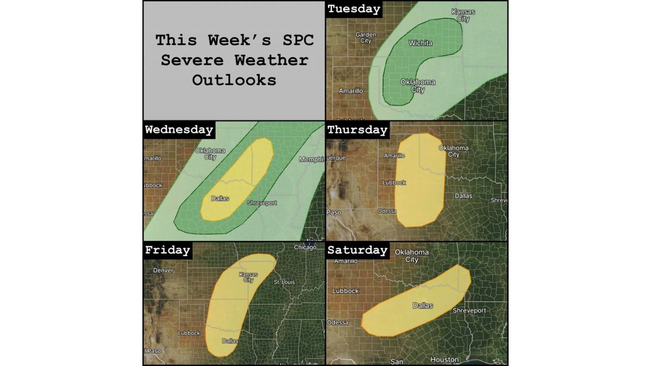
UNITED STATES — March is set to begin with an unusually active stretch of severe weather across the central and southern Plains, as the Storm Prediction Center (SPC) has outlined risk areas for five consecutive days starting Tuesday, March 3.
The focus of this extended threat centers on Texas, Oklahoma, Kansas, and parts of Arkansas and Missouri, signaling a dynamic early-spring setup across the heart of the country.
Tuesday: Kansas and Oklahoma in the Initial Risk Zone
The first round of severe potential on Tuesday highlights areas including:
- Wichita, Kansas
- Oklahoma City, Oklahoma
- Surrounding portions of southern Kansas and central Oklahoma
This setup suggests thunderstorms capable of producing gusty winds and possibly hail as the pattern begins to organize.
Wednesday: Risk Shifts Toward North Texas and Southern Oklahoma
By Wednesday, the severe corridor expands south and east, focusing more heavily on:
- Dallas–Fort Worth, Texas
- Southern Oklahoma
- Near Shreveport, Louisiana
A broader outlook area surrounds the region, indicating increasing instability and moisture across North Texas and adjacent states.
Thursday: West Texas and Oklahoma Targeted
Thursday’s highlighted zone shifts westward into:
- Amarillo, Texas
- Lubbock, Texas
- Portions of western Oklahoma
This signals additional rounds of storm development as energy ejects from the Rockies into the Plains.
Friday: Kansas to North Texas Corridor
Friday’s outlook expands northward again, stretching from:
- Dallas, Texas
- Through central Oklahoma
- Into Kansas City, Missouri
This elongated risk area suggests a stronger organized system capable of supporting multiple severe storm clusters.
Saturday: Texas and Southern Oklahoma Remain in Play
The final day in this five-day stretch keeps:
- Dallas
- Southern Oklahoma
- Near Shreveport
within a severe weather risk area.
While specific hazards will become clearer with additional model data, repeated risk areas over consecutive days indicate sustained atmospheric support for thunderstorm development.
What This Means for Arkansas
Arkansas lies just east of the core risk zones early in the week but could be influenced as the pattern shifts eastward, especially during the latter half of the period.
Given the active Plains setup, downstream impacts into Arkansas are possible depending on storm evolution and frontal timing.
Why This Pattern Matters
Five consecutive days of outlined severe weather risk is not typical for early March and suggests:
- Strong upper-level energy moving through the western U.S.
- Increasing Gulf moisture return
- Repeated frontal boundaries across the Plains
These ingredients often combine to produce multi-day storm episodes during the early spring transition.
Bottom Line
- Severe weather risk outlined Tuesday through Saturday
- Core focus on Texas, Oklahoma, Kansas, and parts of Missouri
- Risk areas shift daily but remain concentrated in the Plains
- Arkansas may be affected later in the week depending on storm progression
For continued updates on this evolving severe weather stretch and how Plains storm systems could impact Arkansas, stay with WaldronNews.com for detailed forecast coverage and regional analysis.