
Arkansas, Texas, Oklahoma and Missouri Caught Between Competing Air Masses as Powerful Thermal Gradient Sets Up Two-Day Storm Track
UNITED STATES — A sharp temperature battle is unfolding across the eastern half of the country, and the dividing line between cool northern air and surging southern warmth will determine where the next storm system tracks over the next 48 hours.
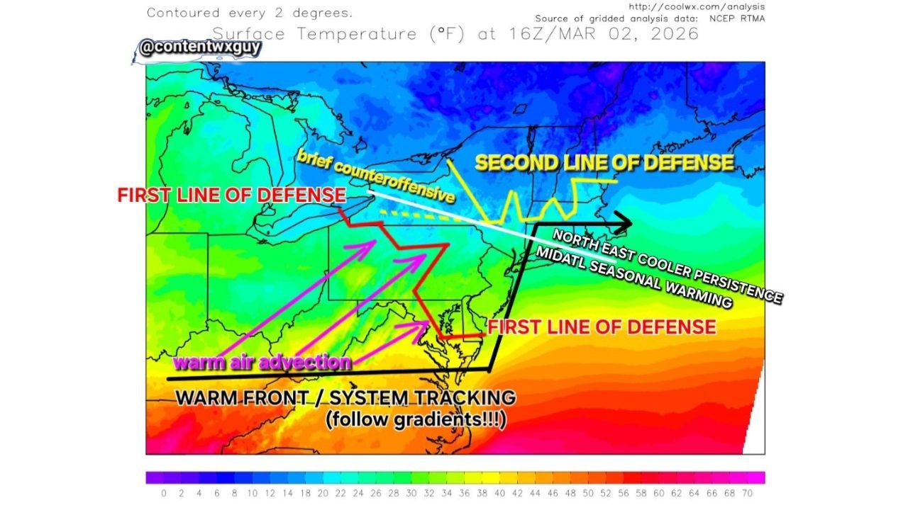
New surface temperature analysis shows a pronounced west-to-east thermal gradient stretching from the southern Plains through Arkansas and into the Mid-Atlantic and Northeast. Meteorologists note that where this boundary tightens, storm systems often follow.
The “First Line of Defense” Over the Midwest and Northeast
Current temperature mapping shows much cooler air locked in across:
- Michigan
- Upstate New York
- Northern Pennsylvania
- Much of New England
This cooler dome is acting as the first barrier to northward warm air intrusion.
Meanwhile, seasonal contrast is striking:
- New England remains in the 50s
- The Upper Mid-Atlantic is pushing into the 70s
That type of demarcation is more typical of April than early March, underscoring how dynamic this setup has become.
Warm Air Advancing From Texas and the Gulf
To the south, much warmer air is surging northward from:
- Texas
- The Gulf Coast
- Through Louisiana, Arkansas, and into Missouri
This process — known as warm air advection — is attempting to lift a warm front northward. However, that push is encountering resistance from the entrenched cooler air to the north.
Forecast analysis suggests the first push may stall before a second, stronger wave forces more significant northward movement.
Arkansas Positioned Near the Battleground
Arkansas sits directly near the tightening temperature gradient — a zone that often becomes the focal point for:
- Storm development
- Enhanced rainfall
- Possible stronger convection depending on system strength
When gradients sharpen like this, meteorologists closely monitor the boundary because storm systems frequently “ride” along these lines.
In this case, guidance suggests the eventual system track could follow the Arkansas-Missouri corridor before lifting toward the Ohio Valley and Mid-Atlantic.
Zonal West-to-East Gradients Taking Shape
Another notable feature is the development of a more zonal (west-to-east) temperature orientation. When these gradients align horizontally across multiple states, they often indicate:
- Strong upper-level flow
- Rapid system progression
- Clear delineation between warm and cool sectors
That pattern can lead to quick temperature swings — sometimes within hours — depending on which side of the boundary a location falls.
The “Second Line of Defense”
As the second push of warmer air develops, forecasters are watching whether it successfully penetrates farther north into:
- Pennsylvania
- New Jersey
- Portions of the Northeast
If successful, the warmer intrusion could shift the storm track northward. If not, systems may remain suppressed closer to Arkansas, Missouri, and the Mid-South.
What It Means for Waldron and Western Arkansas
For residents in Waldron and Scott County, this setup means:
- A potential roller-coaster temperature pattern
- Periods of warm air followed by cooler reinforcements
- Increased monitoring of frontal boundaries over the next two days
Because storm tracks often follow tight thermal gradients, western Arkansas remains in a zone where adjustments in boundary placement could significantly change local impacts.
Bottom Line
- Strong temperature contrast from Texas to New England
- Warm air pushing north from the Gulf
- Cool air entrenched across the Great Lakes and Northeast
- Arkansas near the developing storm track corridor
As this two-day system evolves, the exact placement of that temperature boundary will determine where the heaviest precipitation and strongest weather align.
Stay with WaldronNews.com for continuing updates on how this developing gradient will impact western Arkansas and the surrounding region.