
Arkansas and Oklahoma Could See Mid-80s Heat as Early March Temperatures Surge Toward Record Levels Across the South and Mid-Atlantic
UNITED STATES — An intense early-season warm surge is building across the southern Plains and Mid-South, and new forecast data suggests parts of Arkansas and neighboring Oklahoma could approach the mid-80s by the end of the week — levels that may challenge or break early-March record highs.
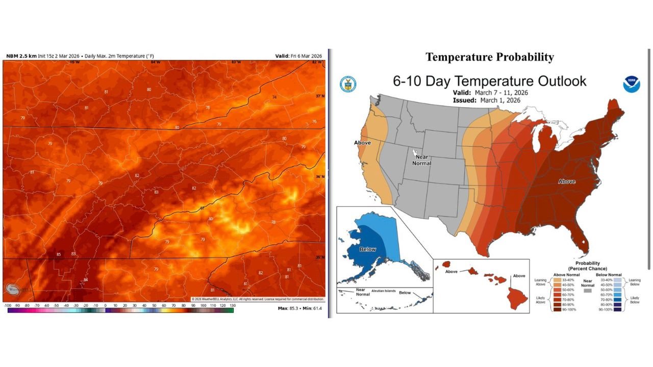
Fresh model projections for Friday, March 6 show a broad swath of 80-plus degree temperatures stretching from central Oklahoma through western and central Arkansas and into Tennessee and Kentucky.
Mid-80s Possible Near the Arkansas-Oklahoma Border
High-resolution temperature guidance indicates:
- Western Oklahoma: up to 84–85°F
- Eastern Oklahoma: low to mid-80s
- Western Arkansas (near Waldron and Fort Smith): lower 80s
- Central Arkansas: around 82–83°F
- Eastern Tennessee and Kentucky: upper 70s to near 80°F
For early March, these numbers are exceptionally warm and more typical of late April or early May.
Waldron and Scott County in the Warm Core
Western Arkansas appears positioned directly within the warm core of this surge. Forecast highs around the lower 80s near Waldron would place the region 20–25 degrees above average for this time of year.
If sunshine remains dominant and mixing is efficient, localized readings could run even warmer in valley locations.
Above-Normal Pattern Expands Eastward
The broader 6-10 day outlook (valid March 7–11) paints an even larger picture:
- Strong probabilities of above-normal temperatures from Texas and Oklahoma through Arkansas, Missouri, Tennessee, Kentucky, and into the Mid-Atlantic and Northeast
- The highest confidence zone includes much of the Southeast and Ohio Valley
- Only the western U.S. shows near-normal to slightly cooler tendencies
That outlook supports the idea that this is not just a brief spike, but part of a sustained warm regime across the eastern half of the country.
Why This Is Unusual for Early March
Climatologically, early March in western Arkansas typically brings highs in the upper 50s to mid-60s. Forecast readings in the 80s represent:
- A dramatic departure from seasonal norms
- A potential challenge to daily record highs
- An accelerated springlike feel weeks ahead of schedule
Meteorologists describe this type of pattern as a strong warm-sector expansion, driven by deep southerly flow and persistent upper-level ridging.
What It Means for Western Arkansas
For residents in Waldron and Scott County, the coming days could feel more like mid-spring than late winter:
- Afternoon temperatures near 80–83°F
- Mild overnight lows
- Increased evaporation and drying if rainfall is limited
However, rapid warmth this early in the season can also prime the atmosphere for stronger storm systems when the next cold front eventually arrives.
Bottom Line
- Highs pushing into the 80s across Arkansas and Oklahoma
- Mid-80s possible in western Oklahoma
- Strong above-normal signal through March 7–11
- Potential record highs for early March
Western Arkansas is set for a dramatic temperature surge as March begins. Stay with WaldronNews.com for continued updates on record potential, daily forecast refinements, and how long this unusual warmth may last.