
Plains Storm Line Could Slam Missouri, Iowa and Illinois Friday Night With Damaging Winds Before Reaching Michigan Early Saturday
ILLINOIS — Early weather model projections show a developing line of thunderstorms forming along a strong cold front across the central Plains Friday evening, potentially tracking east into Missouri, Iowa and Illinois later Friday night before reaching parts of Michigan by early Saturday morning.
Meteorologists say the biggest threat from this system appears to be damaging straight-line wind gusts, though isolated hail and a brief tornado cannot be ruled out as storms organize into a squall line.
Storms Expected to Form Across the Plains Friday Evening
Forecast models indicate storms may begin developing around 6 PM Central Time Friday across parts of the central Plains, particularly near the Kansas–Nebraska–Missouri region.
From there, the storms are expected to organize into a long line along the advancing cold front, moving eastward through the evening.
By 8–9 PM Friday night, the storm line could begin pushing into western Illinois and eastern Missouri, gradually spreading across the state overnight.
Communities potentially impacted include:
- Springfield, Illinois
- Peoria
- Rockford
- Chicago metro area
- Quad Cities region
The line could continue advancing into Michigan and the Great Lakes early Saturday morning.
Damaging Winds Could Be the Primary Hazard
Weather simulations show a narrow but intense band of storms developing along the front, which is typical of fast-moving squall lines capable of producing strong wind gusts.
Forecasters currently believe damaging winds are the most likely hazard with this event.
Possible risks include:
- Strong straight-line wind gusts
- Scattered hail
- A brief isolated tornado
However, overall severe weather potential appears moderate rather than extreme, according to current guidance.
Northern Illinois Could See Midday Storms
Forecast guidance also suggests a separate area of isolated storms developing across northern Illinois earlier in the day Friday, potentially around midday or early afternoon.
These storms could produce localized hail or gusty winds, though they are not expected to be widespread.
By evening, attention will shift to the main squall line advancing from the Plains, which could bring stronger storms overnight.
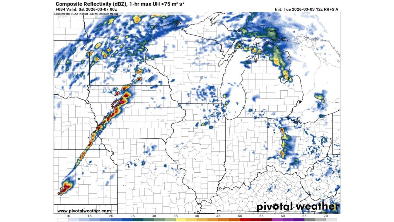
Radar Simulation Shows Organized Storm Line
High-resolution RRFS model radar simulations depict a clear line of thunderstorms stretching from Kansas into Missouri, with additional scattered storms ahead of the system.
As the system progresses eastward, storm clusters may develop across:
- Iowa
- Illinois
- Indiana
- Michigan
Meanwhile, some scattered activity may also develop around the Great Lakes region, particularly near Lake Michigan and northern Michigan.
Forecast Still Developing
Meteorologists caution that the system is still several days away, meaning storm intensity and exact timing may shift as new model data becomes available.
The exact track of the cold front and the level of atmospheric instability will determine how strong the storms become as they reach Illinois and surrounding states.
Residents across the Midwest and Great Lakes are encouraged to monitor updates as the forecast evolves through the week.
Stay with WaldronNews.com for continuing updates on Midwest weather, severe storm alerts, and real-time forecast changes as this late-week system approaches.