
Northern Great Plains Calms Into Late May and Early June With High Pressure Bringing Denver to 55 Degrees, Chicago to 61 and Houston to 75 by Saturday May 30
DENVER, Colorado — The active severe weather pattern gripping the country is set to calm down significantly heading into late May and early June, as a strong high-pressure system builds over the Great Plains. By Saturday, May 30, 2026, forecasts show a quieter and warmer pattern locked in across the northern Great Plains. Residents who have been dealing with repeated storm threats should see a meaningful break during this period.
Why Severe Weather Is Slowing Down
A strong high-pressure system and ridge are forecast to set in over the Great Plains through late May into early June 2026. A high-pressure system is an area of sinking, stable air that suppresses storm development, clears the skies and allows temperatures to climb. Think of it as a large atmospheric dome that pushes weather systems away and brings calm, sunny conditions to the area underneath it.
What Is a Ridge and How Does It Affect You
A ridge is simply an extended arm of high pressure that stretches across a broad area. When a ridge settles over the Great Plains, it blocks the cold fronts and storm systems that would otherwise trigger severe weather. For communities across the northern Great Plains, this means the threat of tornadoes, damaging winds and large hail drops sharply for an extended stretch of days.
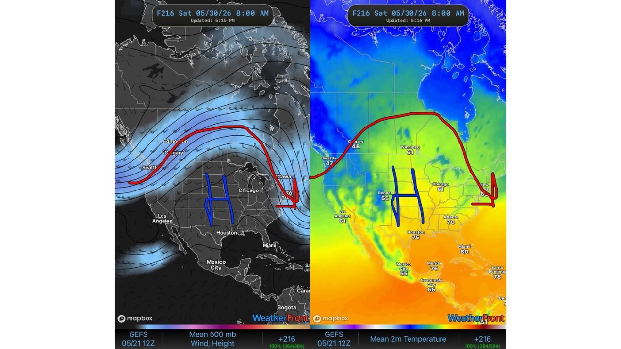
Forecast Temperatures for Saturday May 30 at 8:00 AM
The temperature forecast valid for Saturday, May 30, 2026 at 8:00 AM reflects the warming trend spreading under the high-pressure system. Here are the forecast readings for cities shown in the source data:
- Denver is forecast to reach 55 degrees by Saturday morning, May 30, showing a mild reading near the edge of the Rocky Mountains as the warm pattern builds eastward across the Great Plains.
- Chicago is forecast to reach 61 degrees by Saturday morning, May 30, reflecting the warmth spreading northward into the Great Lakes region as the ridge takes hold.
- Houston is forecast to reach 75 degrees by Saturday morning, May 30, consistent with the warm and humid air that characterizes Gulf Coast conditions under high pressure.
- Atlanta is forecast to reach 70 degrees by Saturday morning, May 30, while Miami is expected to reach 80 degrees as heat builds across the Southeast under the dominant high-pressure dome.
- New York is forecast to see 65 degrees by Saturday morning, May 30, showing the warming influence reaching the East Coast as well.
- Seattle is forecast to reach just 47 degrees by Saturday morning, May 30, as cooler conditions persist across the Pacific Northwest, well outside the warm ridge centered over the Great Plains.
- Los Angeles is forecast to reach 61 degrees by Saturday morning, May 30, reflecting mild west coast conditions typical of this time of year.
- Calgary is forecast to see 48 degrees by Saturday morning, May 30, and Winnipeg is forecast to reach 61 degrees, showing the warming influence of the ridge extending northward into Canada even as the core warmth remains centered over the northern Great Plains.
What This Pattern Means Through Early June
The source data confirms that warmer temperatures are expected to continue across most of the northern Great Plains through this entire period. Communities that have endured repeated rounds of severe weather in recent weeks should see a significant break as the high-pressure system and ridge hold firm through late May and into early June 2026. This kind of pattern typically brings sunny skies, light winds and above-normal temperatures to the region.
Is All Severe Weather Gone During This Period
Not entirely, but the risk is greatly reduced. When a strong high-pressure ridge dominates the Great Plains, the atmospheric ingredients needed for severe storms such as moisture, lift and instability are suppressed. While isolated storm chances can never be fully ruled out, the overall threat level drops well below what the region has seen in recent weeks. Residents should still stay aware of any local forecasts during this stretch.
WaldronNews.com will continue tracking the high-pressure system and warming trend across the northern Great Plains and Great Plains and will provide updates as temperature forecasts and severe weather conditions through early June 2026 develop.