
Indiana and Kentucky Face Widespread Rain by 1:00 PM ET and Strong Storms From Louisville to Lexington This Friday Afternoon and Evening Including Indianapolis, Cincinnati and Dayton
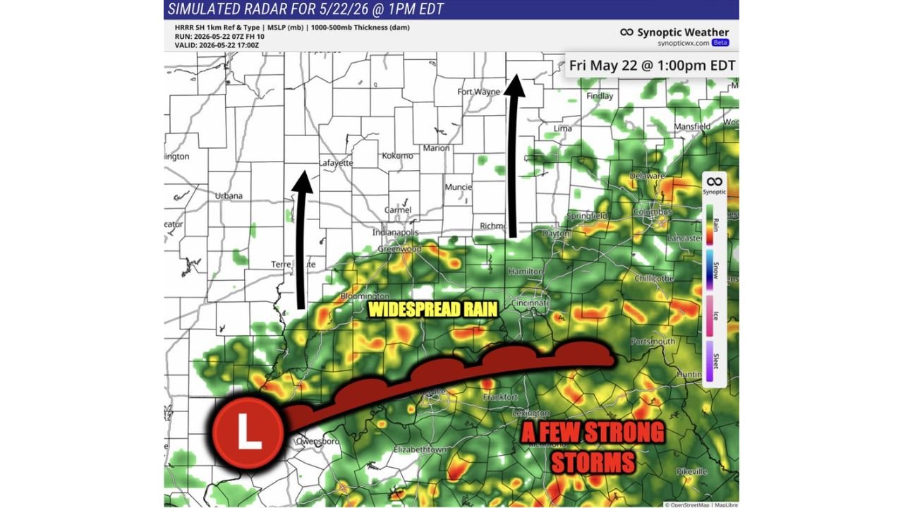
INDIANAPOLIS, Indiana — Widespread rain is closing in on Indianapolis, Indiana with arrival expected around 1:00 PM ET this Friday, May 22, 2026, timed to hit right at the end of Final Practice on Carb Day. To the south, a separate and more dangerous threat is taking shape with strong storms possible along a corridor from Louisville to Lexington, Kentucky through this afternoon and evening.
Rain Arrives in Indianapolis at 1:00 PM ET Friday
The widespread rain is moving northward out of Kentucky and pushing into central Indiana throughout Friday morning and early afternoon. Forecasters pinpoint the arrival in Indianapolis at approximately 1:00 PM ET, with Carmel and Greenwood also falling within the incoming rain zone at that time. Bloomington, Indiana is already in the thick of the precipitation as the system tracks steadily north.
What Is a Warm Front and Why It Matters Today
A warm front is a boundary in the atmosphere where warmer air pushes northward and undercuts cooler air sitting in place. These boundaries concentrate moisture and instability in a tight line, making them prime locations for strong storm development. Today that warm front is draped across Kentucky, placing Louisville and Lexington directly in the firing line for strong storms this Friday afternoon and evening.
Indiana Cities in the Widespread Rain Zone
The widespread rain zone stretches across a large portion of Indiana and into Ohio as of 1:00 PM ET Friday, May 22, 2026. Here is where the rain is expected:
- Indianapolis, Carmel and Greenwood are directly in the path of the incoming rain expected around 1:00 PM ET on Friday, May 22, with outdoor conditions deteriorating through the afternoon hours.
- Bloomington, Indiana is within the widespread rain zone and will see wet conditions throughout much of this Friday afternoon.
- Lafayette, Kokomo and Muncie in north-central Indiana are ahead of the rain line as of 1:00 PM ET but are expected to see conditions worsen as the system pushes northward through Friday afternoon.
- Terre Haute, Richmond and Marion in Indiana are also within or near the widespread rain footprint shown on the Friday, May 22 forecast map.
- Fort Wayne, Indiana in the northeast is currently ahead of the incoming rain but sits in the path of the system as it continues moving north through Friday afternoon.
Ohio Cities Also Seeing Widespread Rain This Friday
The widespread rain extends east into Ohio as the system spreads across the region on Friday, May 22, 2026. Cities in the affected zone include:
- Cincinnati, Dayton and Hamilton, Ohio are within the widespread rain footprint as the precipitation spreads east across the region throughout Friday afternoon.
- Columbus, Springfield and Delaware, Ohio fall within the broader area of coverage shown on the Friday, May 22 forecast, with rain expected through the afternoon and evening hours.
- Lancaster, Chillicothe and Portsmouth, Ohio are also visible within the rain zone on the Friday, May 22 forecast map as the system pushes east.
- Findlay, Lima and Mansfield, Ohio in the northern part of the state are ahead of the immediate rain line but are in the northward path of the system as conditions develop through Friday afternoon.
Strong Storm Threat From Louisville to Lexington This Afternoon and Evening
The most dangerous weather today is concentrated in Kentucky, not Indiana. A few strong storms will be possible along the warm front from Louisville to Lexington through this Friday afternoon and evening:
- Louisville, Kentucky sits at the western end of the identified strong storm corridor, placed directly along the warm front where the heaviest storm activity is most likely to develop through this Friday afternoon and evening.
- Lexington, Kentucky anchors the eastern end of the strong storm risk zone, with conditions along the warm front favorable for storm development from the afternoon through the evening hours of Friday, May 22.
- Frankfort, Kentucky sits between Louisville and Lexington along the warm front corridor and falls within the storm threat area for this Friday afternoon and evening.
- Owensboro and Elizabethtown, Kentucky are also visible within or near the storm development zone on the Friday, May 22 forecast map.
- Pikeville, Kentucky is visible in the far eastern portion of the Kentucky storm activity area on the Friday, May 22 forecast.
What You Should Do Right Now
If you are outdoors in Indianapolis, Indiana today, expect wet conditions to arrive around 1:00 PM ET on Friday, May 22, 2026 and plan accordingly. For residents in Louisville and Lexington, Kentucky, the threat today is more significant than simple rain, with strong storms capable of dangerous conditions possible through Friday evening. Stay alert to local warnings and move indoors quickly if storms develop near your location.
WaldronNews.com will continue tracking the widespread rain moving through Indianapolis and the strong storm threat from Louisville to Lexington, Kentucky and will provide updates as conditions develop through Friday evening, May 22, 2026.