
Severe Thunderstorm Outbreak Risk Expands Across Texas, Oklahoma and Kansas Thursday With Large Hail and Tornado Threat
UNITED STATES — A potentially significant severe weather event is expected Thursday across parts of the Southern Plains, where meteorologists say conditions could support large hail, damaging winds, and a few tornadoes as powerful thunderstorms develop.
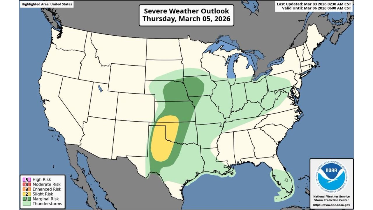
The Storm Prediction Center (SPC) has outlined a broad severe weather risk stretching from Texas through Oklahoma and into Kansas, with the highest concentration of storms likely across western Texas and eastern New Mexico.
Southern Plains Targeted for Severe Thunderstorms
The latest severe weather outlook for Thursday, March 5, 2026, highlights a corridor of unstable air spreading north from Texas into the central Plains.
Areas included within the severe weather outlook include:
- Texas
- Oklahoma
- Kansas
- Nebraska
- Portions of Missouri and Arkansas
Storm development is expected as warm, moist air surges northward ahead of an approaching storm system, creating an environment favorable for strong thunderstorms.
Large Hail Appears to Be the Primary Threat
Forecasters say the most significant hazard from Thursday’s storms could be very large hail, which is often associated with powerful supercell thunderstorms.
However, other severe weather risks are also possible, including:
- Damaging straight-line winds
- Isolated tornadoes
- Heavy downpours and frequent lightning
The area highlighted for the highest severe risk currently centers on parts of western Texas and eastern New Mexico, where atmospheric instability may be strongest.
Storm Risk Extends Toward the Midwest
Beyond the core severe weather region in the Southern Plains, a broader area of thunderstorms may stretch northeast into:
- Kansas
- Nebraska
- Missouri
- Illinois
- Indiana
- Kentucky
While severe storms in these regions may be less intense, forecasters say scattered thunderstorms remain possible as the system moves eastward.
Storm Setup Could Become One of the More Notable Events Recently
Meteorologists caution that Thursday’s setup could become one of the more significant severe weather days seen recently in the Plains, especially if storms organize into rotating supercells.
Several atmospheric ingredients are coming together, including:
- Strong wind shear
- Increasing Gulf moisture
- Rising atmospheric instability
These ingredients can create favorable conditions for supercell thunderstorms capable of producing severe weather.
Forecast Still Being Refined
Although confidence is growing that severe storms will develop, meteorologists say storm timing, location, and intensity could still shift as new forecast data becomes available.
Residents across Texas, Oklahoma, Kansas and nearby states are encouraged to stay alert to weather updates as Thursday approaches.
Severe weather season often ramps up during early spring across the Plains, when warm Gulf air collides with cooler air from the north, producing volatile weather patterns.
Stay with WaldronNews.com for the latest severe weather updates, storm tracking, and safety alerts as this developing system approaches the Southern Plains.