
Dangerous Severe Storm Corridor Emerging From Texas Through Oklahoma Into Kansas as SPC Highlights High Impact Zone for Thursday
UNITED STATES — A potentially significant severe weather corridor is taking shape across the Southern and Central Plains, where forecasters warn that powerful thunderstorms capable of producing large hail, damaging winds, and possible tornadoes could develop Thursday.
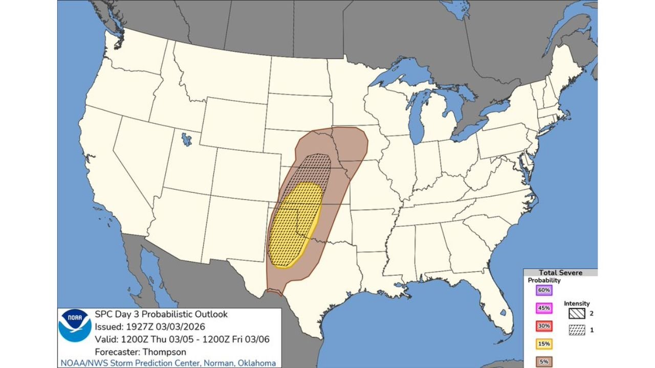
New data from the NOAA Storm Prediction Center’s Day 3 outlook for March 5–6, 2026 shows a focused area of severe storm potential stretching from Texas northward through Oklahoma and into Kansas, with the greatest risk centered in parts of the southern Plains.
Highest Severe Weather Potential From Texas Into Oklahoma
The latest probabilistic outlook map highlights a core severe weather zone extending from western and central Texas through Oklahoma and into southern Kansas.
Cities and regions within the highlighted severe weather corridor include:
- Amarillo, Texas
- Lubbock, Texas
- Wichita Falls, Texas
- Oklahoma City, Oklahoma
- Tulsa, Oklahoma
- Wichita, Kansas
Within this corridor, atmospheric conditions could support strong supercell thunderstorms capable of producing significant hail and intense wind gusts.
Large Hail Could Become the Most Significant Threat
Meteorologists analyzing the setup say large hail appears to be the primary hazard with this system.
Supercell thunderstorms forming in the highlighted zone may produce:
- Very large hailstones
- Damaging straight-line winds
- Isolated tornadoes
- Frequent lightning and heavy rain
The presence of strong atmospheric instability combined with favorable wind patterns could allow storms to become organized and long-lived.
Severe Weather Zone Expands Into the Central Plains
While the core threat remains focused across Texas, Oklahoma, and Kansas, a broader severe weather region extends farther north and east across portions of the central Plains and Midwest.
States potentially seeing thunderstorms include:
- Nebraska
- Missouri
- Arkansas
However, storms in these surrounding regions may be more scattered compared with the primary severe zone across the southern Plains.
SPC Outlook Highlights Elevated Severe Probabilities
The Storm Prediction Center probability outlook shows the most concentrated severe weather risk positioned across the Texas–Oklahoma border region, where conditions may be most favorable for rotating storms.
This highlighted region represents the area where multiple severe weather ingredients could overlap, including:
- Strong wind shear
- Increasing Gulf moisture
- Atmospheric instability
When these ingredients align, they often lead to supercell thunderstorms capable of producing severe weather outbreaks.
Forecast Still Developing
Although confidence is increasing that severe storms will develop Thursday, meteorologists emphasize that exact storm timing, intensity, and location may still shift as the event approaches.
Residents across Texas, Oklahoma, and Kansas are encouraged to stay alert to forecast updates and prepare for possible severe weather as conditions evolve.
Early spring frequently marks the beginning of the central U.S. severe weather season, when warm Gulf air collides with colder air from the north.
Stay with WaldronNews.com for continuing updates, severe weather alerts, and live storm tracking as this developing Plains storm system approaches.