
Possible Late-Season Winter Setup Targets New York, Pennsylvania, Massachusetts and New England Around March 16–17 as Jet Stream Pattern Turns Unstable
UNITED STATES — Meteorologists are closely watching a developing atmospheric pattern that could bring one final round of winter-like weather to parts of the Northeast around March 16–17, although early analysis suggests the setup may end up messy rather than producing a major storm.
Forecast guidance from long-range atmospheric models shows several fast-moving disturbances crossing North America in the coming days. These systems could temporarily disrupt the jet stream pattern and open a window where colder air and storm energy align across the eastern half of the United States.
However, the current atmospheric configuration suggests any potential storm development may struggle to organize into a significant winter event.
Western Ridge and Eastern Trough Could Create a Winter Opportunity
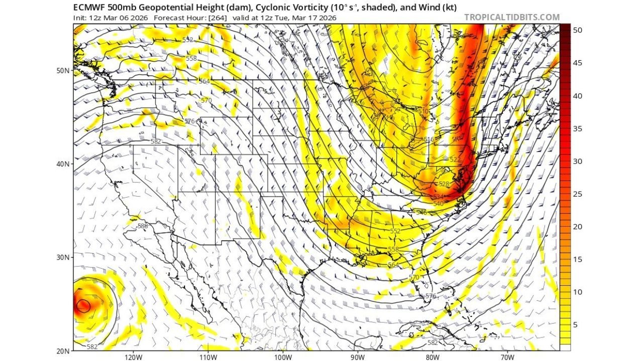
Forecast maps analyzing 500-millibar geopotential height patterns and cyclonic vorticity show a large trough dipping southward across the eastern United States by mid-March.
This pattern often creates conditions favorable for storm development because it allows:
- Cold air to push southward from Canada
- Energy to spin up along the jet stream
- Storm systems to track along the East Coast
At the same time, meteorologists expect a ridge of high pressure to attempt to rebuild over the western United States, which would help amplify the trough over the eastern half of the country.
If this configuration strengthens, it could create a classic late-season setup capable of producing snow or mixed precipitation somewhere in the Northeast.
Fast-Moving Energy Could Disrupt the Setup
Despite the potentially favorable large-scale pattern, forecasters say the jet stream flow across North America remains extremely active, with multiple small disturbances racing across the continent.
These fast-moving waves can interfere with one another, preventing the atmosphere from concentrating enough energy to generate a strong storm system.
Current model analysis shows that much of the atmospheric energy may race northward ahead of any southern storm development, limiting the ability for a deep coastal system to form.
This makes the outcome far less predictable.
Southern Stream Energy Arriving Late
Another complication involves the timing of energy coming from the southern branch of the jet stream.
For a major East Coast winter storm to develop, meteorologists often look for northern and southern jet stream systems to phase together, combining their energy.
In this potential scenario, however, the southern stream disturbance appears likely to arrive later than the northern system, which would prevent the two from fully interacting.
Without that interaction, storms tend to remain weaker and less organized.
Eastern U.S. Remains the Focus
Even with the uncertainties, forecasters are watching the eastern half of the United States closely, where abundant atmospheric spin — known as vorticity — will be present.
This means smaller disturbances embedded in the flow could still develop into localized storm systems as they move east.
Because of that, weather conditions across the Northeast could remain changeable and unsettled through mid-March.
Why It’s Too Early to Predict a Major Storm
Long-range weather forecasting often involves evaluating evolving atmospheric signals many days in advance. At this stage, the pattern suggests a possible opportunity for winter weather, but the ingredients for a major storm are not clearly aligning yet.
Meteorologists note that many shortwave disturbances will move through the atmosphere between now and mid-March, and each one has the potential to slightly alter the jet stream pattern.
Even small changes could shift storm tracks, temperatures, and precipitation types.
For now, the March 16–17 window remains one of the more interesting periods to monitor, especially for parts of the Northeast that could still experience late-season winter weather.
Whether that window produces a meaningful storm or just scattered unsettled weather will depend on how the jet stream evolves over the next several days.
Stay with WaldronNews for continued updates as meteorologists refine the mid-March forecast and monitor potential late-season winter threats across the United States.