
Alabama Storm Threat Overnight Sunday Into Monday as North and West Alabama Face Enhanced Risk for Tornadoes and Damaging Winds
ALABAMA — A developing severe weather threat is expected to move across Alabama late Sunday night into early Monday morning, with meteorologists warning that storms could bring damaging winds and a few tornadoes across much of the state, particularly across north and west Alabama.
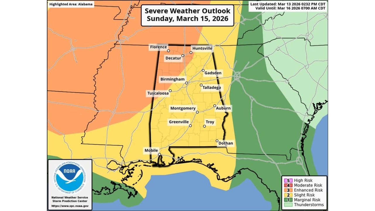
The Storm Prediction Center (SPC) has placed parts of northwestern and western Alabama under a Level 3 out of 5 “Enhanced Risk”, signaling an elevated potential for organized severe thunderstorms.
The remainder of the state is under a Level 2 “Slight Risk,” indicating that severe weather will still be possible across much of Alabama as the storm system moves through overnight.
Storms Expected to Enter Northwest Alabama Around Midnight
Forecast models indicate that a strong cold front will move into the state from the northwest Sunday night, triggering a line of thunderstorms that will track across Alabama overnight.
Current projections suggest the storms will:
- Enter northwest Alabama around midnight Sunday night
- Move southward through central Alabama during the overnight hours
- Exit southeastern Alabama around 8–9 a.m. Monday morning
Cities likely to be impacted during the overnight event include:
- Florence
- Decatur
- Huntsville
- Birmingham
- Tuscaloosa
- Montgomery
- Mobile
- Dothan
Because the storms are expected during pre-dawn hours, many residents may be asleep when severe weather occurs.
Damaging Winds Expected to Be the Primary Threat
Meteorologists say the main hazard from this system will likely be damaging straight-line winds, which could occur as thunderstorms organize into a fast-moving squall line along the advancing cold front.
These storms may produce wind gusts capable of:
- Downing trees
- Damaging power lines
- Causing scattered power outages
- Producing structural damage in some areas
Strong winds are often the most widespread impact in overnight squall-line events across the Southeast.
Tornado Risk Also Possible Across Alabama
Although damaging winds are expected to be the primary concern, forecasters warn that a few tornadoes may develop within the storm system.
These tornadoes could form:
- Along the main line of storms
- Within rotating segments embedded in the squall line
- Possibly ahead of the main storm line if isolated storms develop
Because nighttime tornadoes can be especially dangerous due to reduced visibility and sleeping residents, meteorologists emphasize the importance of having reliable ways to receive warnings.
Atmospheric Conditions Favor Strong Storm Development
Forecast guidance shows strong upper-level winds and sufficient atmospheric instability developing across Alabama Sunday night as the cold front approaches.
Even though the storms will occur during nighttime hours — when instability typically decreases — the presence of strong wind dynamics in the atmosphere could allow storms to maintain strength.
This combination of factors is why the SPC has issued the Enhanced Risk for portions of the state.
Residents Encouraged to Prepare for Overnight Severe Weather
Because the storms are expected during the middle of the night, weather experts urge residents across Alabama to review their severe weather safety plans ahead of time.
Meteorologists recommend:
- Having a NOAA Weather Radio for overnight warnings
- Keeping phone alerts enabled for emergency weather alerts
- Identifying a safe shelter location inside the home
- Monitoring weather updates through the weekend
Nighttime severe weather events historically carry greater risk because warnings may go unnoticed while people are asleep.
Storm Threat Will Continue to Be Monitored
Meteorologists will continue monitoring forecast data through the weekend as new model runs help refine the expected storm timing and intensity.
Small changes in the storm track or timing could affect which parts of Alabama experience the strongest storms.
However, current projections suggest that north and west Alabama have the greatest risk for severe weather late Sunday night into early Monday morning.
Stay with WaldronNews for continuing updates as meteorologists track this developing severe weather threat across Alabama.