
Kentucky Tornado Watch Covers Lexington, Richmond and Paris as Rotating Storms Approach Central Kentucky Communities
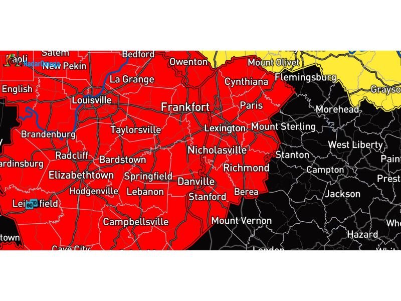
KENTUCKY — A Tornado Watch has been issued for parts of central Kentucky, placing several communities including Lexington, Richmond, Paris and Winchester under heightened alert as meteorologists track storms capable of producing tornadoes moving toward the region.
The watch area stretches across a large portion of central Kentucky and includes cities such as Georgetown, Berea, Nicholasville, Stanford and Cynthiana, where atmospheric conditions could support rotating thunderstorms during the watch period.
Weather officials say radar is already detecting spinning storms moving closer to the region, increasing concern that tornadoes could develop as the system moves through.
Cities Across Central Kentucky Under the Tornado Watch
The watch includes multiple counties across central Kentucky, covering major communities such as:
- Lexington
- Winchester
- Paris
- Georgetown
- Berea
- Richmond
- Nicholasville
- Stanford
- Cynthiana
Other nearby cities such as Frankfort, Danville, Mount Sterling and Bardstown also lie within the broader severe weather zone shown on the radar map.
These areas are being closely monitored as storms move northeast across Kentucky.
Rotating Storms Moving Toward the Region
Meteorologists say the tornado watch was issued because storms approaching the area have shown signs of rotation, a key ingredient for tornado development.
When thunderstorms begin rotating, they can quickly evolve into supercell storms, which are capable of producing tornadoes along with:
- Damaging wind gusts
- Large hail
- Intense lightning
Radar images indicate that storms developing to the west and southwest of the watch area are gradually approaching central Kentucky.
If those storms maintain rotation as they move into the watch region, tornado warnings could be issued with little notice.
Storms Developing Across the Ohio Valley
The tornado watch comes as a broader severe weather system moves through parts of the Ohio Valley and Mississippi Valley, where unstable air and strong wind shear are combining to create favorable conditions for severe thunderstorms.
Warm, moist air moving northward from the Gulf of Mexico is colliding with cooler air and powerful winds higher in the atmosphere, allowing storms to strengthen rapidly.
Meteorologists say this environment can support organized storm systems capable of producing tornadoes and damaging winds across Kentucky and neighboring states.
Residents Urged to Stay Weather-Aware
Because tornadoes can develop quickly during these events, officials are urging residents across central Kentucky to stay alert and prepared for warnings.
Safety experts recommend:
- Keeping Wireless Emergency Alerts enabled on smartphones
- Monitoring local weather radar and updates
- Identifying a safe shelter location inside homes or buildings
- Being ready to act quickly if a tornado warning is issued
A tornado watch means that conditions are favorable for tornado development, though a tornado has not yet been confirmed.
If warnings are issued, residents should move immediately to a basement or an interior room on the lowest floor of a sturdy building away from windows. Meteorologists say the situation will continue to evolve as storms move across Kentucky.
Stay with WaldronNews for continuing updates as severe storms approach Lexington, Richmond and surrounding central Kentucky communities.