
Washington DC, Columbia and Germantown in Path of Severe Storm Line as Tornado Warning Near Southern Maryland Raises Urgent Concerns
MARYLAND — A powerful line of severe thunderstorms is moving through the Mid-Atlantic tonight, placing communities including Germantown, Washington D.C. and Columbia directly in its path as forecasters warn of damaging winds and a nearby tornado threat.
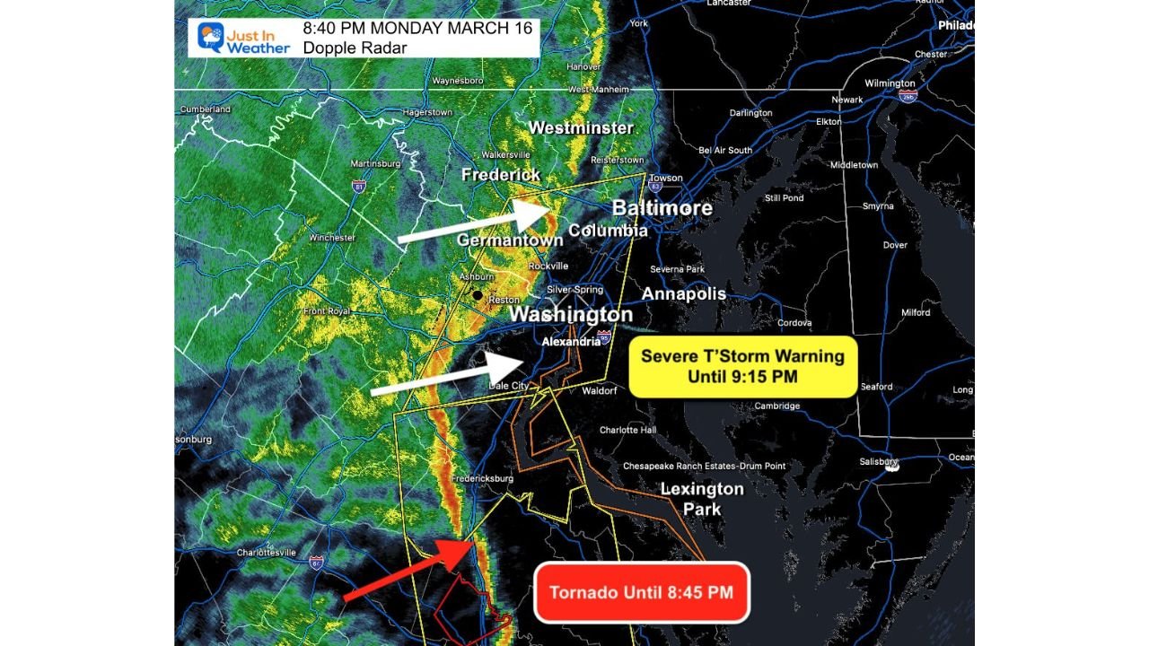
As of late Monday evening, a Severe Thunderstorm Warning remains in effect until 9:15 p.m., with the main storm line advancing east toward heavily populated areas including Baltimore and Annapolis.
Damaging Winds and Heavy Rain Moving Through DC Metro
Meteorologists say the approaching line of storms is on schedule and strengthening, capable of producing wind gusts up to 60 mph along with bursts of heavy rain and frequent lightning.
Radar imagery shows a well-defined squall line pushing across the region, with the strongest storms stretching from Fredericksburg through Washington D.C. and into areas near Columbia and Germantown.
Residents in these areas can expect:
- Sudden strong wind gusts
- Heavy rain reducing visibility
- Brief but intense downpours
Although storms are moving quickly, conditions may deteriorate rapidly as the line passes through.
Baltimore and Annapolis Next in Line
Forecasters warn that Baltimore and Annapolis are next in the path of this storm system, with arrival expected shortly after the line clears the Washington metro area.
Communities along the Chesapeake Bay could experience strong winds and heavy rain as the system continues tracking east.
Tornado Warning in Southeast Virginia Raises Concern
Adding to the urgency, a Tornado Warning remains active in parts of southeastern Virginia, prompting meteorologists to closely monitor the storm line as it pushes into southern Maryland.
Experts warn that embedded rotation within the line could allow for brief tornado development, especially as storms interact with favorable atmospheric conditions.
Residents across southern Maryland are being urged to stay alert as the storm approaches.
Rapid Weather Changes Expected Overnight
In addition to severe storms, colder air is expected to move in behind the system, though rain may linger for a period after the main line passes.
This could lead to a sharp drop in temperatures overnight while wet conditions continue across parts of the region.
Residents Urged to Stay Alert
Officials are urging residents across the Mid-Atlantic to remain vigilant as severe weather continues to move through the area.
Safety recommendations include:
- Staying indoors during the storm
- Monitoring local weather alerts
- Being prepared to take shelter quickly if warnings are issued
Because storms are moving quickly, warning lead times may be short.
Meteorologists emphasize that even storms below tornado intensity can still produce damaging winds capable of downing trees and power lines.
Stay with WaldronNews for continuing updates as severe storms push through Washington D.C., Maryland and surrounding areas with damaging winds and possible tornado development.