
Virginia, Maryland, D.C., and North Carolina See Storm Threat Ease as “Off-Ramp” Scenario Begins to Take Shape
WASHINGTON, D.C. — A potentially volatile severe weather setup across the Mid-Atlantic and parts of the Southeast is now showing early signs of easing, as forecasters point to a developing “off-ramp” scenario that could significantly reduce the overall storm intensity later in the day.
Early reports confirmed a few weaker tornadoes north of Washington, D.C., but meteorologists now say the broader system may be losing its edge — not because conditions aren’t supportive, but because storms themselves may be consuming the available energy too quickly.
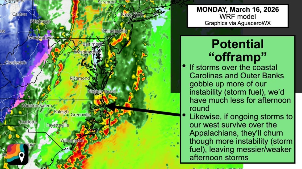
What the “Off-Ramp” Scenario Means
The term “off-ramp” in weather forecasting refers to a situation where the atmosphere begins to stabilize earlier than expected, preventing a full-scale severe outbreak.
In this case, storms developing over North Carolina, especially along the Outer Banks and coastal regions, are playing a critical role. These early storms are effectively “eating up” instability — the warm, moist air that fuels severe thunderstorms.
If this trend continues, it means:
- Less available energy for later storms across Virginia, Maryland, and Washington, D.C.
- Reduced risk of widespread severe weather during the afternoon and evening
- More scattered and weaker storm activity instead of a large-scale outbreak
Carolinas Storms Acting as a Pressure Release Valve
Radar and model guidance indicate that coastal North Carolina and eastern parts of the state are seeing organized storm clusters early in the day.
These storms are important because they:
- Disrupt the inflow of warm, unstable air moving northward
- Stabilize parts of the atmosphere before peak heating hours
- Limit how intense storms can become further inland
At the same time, storms moving through the Appalachian region — including western Virginia and parts of West Virginia — may also contribute to this weakening trend. If these storms hold together, they can further “churn” through instability before it reaches major population centers.
Impact on Virginia, Maryland, and D.C.
For areas like Richmond, Virginia Beach, Washington, Baltimore, and surrounding regions, this evolving setup could mean a noticeable downgrade in severe weather potential.
Instead of a high-end event, residents may see:
- Bands of rain and embedded thunderstorms
- Brief gusty winds
- Isolated severe cells rather than widespread damage
However, forecasters are still urging caution. Even in a weakened setup, isolated storms can still produce:
- Strong wind gusts
- Brief tornado spin-ups
- Heavy downpours leading to localized flooding
Why Forecast Frustration Happens
Meteorologists acknowledged that situations like this can lead to frustration among the public, especially when earlier forecasts suggested a more significant threat.
But this shift highlights how sensitive severe weather setups are to timing and storm evolution.
In this case:
- Earlier storms are interfering with later development
- Atmospheric energy is being redistributed unevenly
- Small changes in storm timing are having large impacts on outcomes
Forecasters emphasize that this is not a “miss” — but rather a real-time adjustment based on how the atmosphere is behaving.
Northern Areas Already Seeing Limited Tornado Activity
There have already been reports of weaker tornadoes north of Washington, D.C., but these have remained relatively limited in both strength and coverage.
This aligns with the “off-ramp” idea:
- Storms are forming, but not maximizing their full potential
- Tornadic activity is isolated rather than widespread
- The environment is supportive, but not fully optimized
What Happens Next
The key question now is whether this stabilizing trend continues through the afternoon.
If storms in the Carolinas and Appalachians keep consuming instability:
- The Mid-Atlantic will likely avoid a major severe outbreak
- Storms will remain disorganized and less intense
- The overall threat level will continue to decrease
However, if new instability builds back in — even briefly — there is still a window for:
- Stronger storm redevelopment
- Isolated severe warnings
- Short bursts of dangerous weather
Bottom Line for Residents
For people across North Carolina, Virginia, Maryland, and Washington, D.C., the situation is improving — but not completely risk-free.
- The worst-case scenario appears less likely
- Scattered storms will still move through the region
- Isolated severe weather remains possible
Residents should continue monitoring updates, especially through the afternoon hours when conditions can still change quickly.
A System Still Worth Watching
Even with signs of weakening, this system is not fully done. Weather patterns like this can shift rapidly, and small atmospheric changes can still lead to localized impacts.
The developing “off-ramp” scenario is a positive sign — but not a guarantee.
Stay tuned to WaldronNews.com for continued updates as forecasters analyze how this evolving storm system ultimately plays out across the Mid-Atlantic and Southeast.