
Washington D.C., Virginia, and Maryland Hit by Explosive Cold Front as Temperatures Crash Over 20°F in Minutes and Winds Surge Near 70 MPH
WASHINGTON, D.C. — A powerful cold front blasted through the Mid-Atlantic, delivering a sudden and dramatic temperature collapse across Washington, D.C., northern Virginia, and parts of Maryland, with conditions changing in a matter of minutes.
What began as a mild evening quickly turned into a sharp cold snap as the front surged through — bringing intense winds, rapid cooling, and a striking temperature divide across the region.
Temperatures Collapse in Minutes Across Key Locations
The most dramatic changes were recorded at major observation sites, highlighting just how aggressive this frontal passage was.
- Dulles Airport (Virginia): Temperatures plunged from 64°F at 8:20 PM to 41°F by 8:45 PM — a 23°F drop in just 25 minutes
- Reagan National Airport (DCA): Fell from 63°F at 9:00 PM to 47°F by 9:12 PM — a 16°F drop in only 12 minutes
These kinds of rapid drops are rare and typically signal the arrival of a strong, well-defined cold front with intense atmospheric forcing.
Damaging Winds Accompany the Temperature Crash
As the front pushed through, it wasn’t just temperatures that changed rapidly — winds intensified sharply as well.
- A peak gust of 68 mph was recorded at Reagan National Airport
Winds of this magnitude are capable of:
- Breaking tree limbs
- Causing scattered power outages
- Creating dangerous driving conditions, especially for high-profile vehicles
The combination of plunging temperatures and powerful winds made the transition feel even more abrupt and severe.
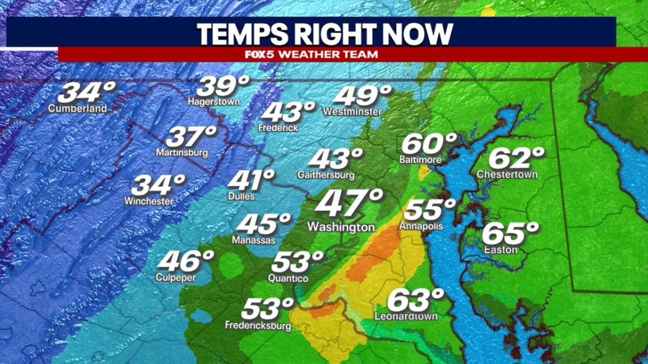
A Sharp Temperature Divide Across the Region
Temperature readings across the Mid-Atlantic revealed a dramatic contrast depending on which side of the front you were on.
West of the front (cold air already in place):
- Cumberland: 34°F
- Winchester: 34°F
- Martinsburg: 37°F
Near the frontal boundary:
- Dulles: 41°F
- Manassas: 45°F
- Washington, D.C.: 47°F
East of the front (warmer air still holding):
- Baltimore: 60°F
- Annapolis: 55°F
- Easton: 65°F
- Leonardtown: 63°F
This shows a 20 to 30 degree temperature difference across relatively short distances, underscoring how sharp and intense the front was.
What Caused This Sudden Weather Shift
This event was driven by a strong cold front tied to a larger storm system moving across the eastern United States.
Key drivers included:
- A surge of colder, denser air advancing rapidly from the west
- Strong pressure differences accelerating wind speeds
- A tightly defined boundary separating warm and cold air masses
As the front passed each location, warm air was quickly forced out and replaced by colder air, leading to the sudden drop in temperatures.
Why This Event Stands Out
While cold fronts are common, the speed and intensity of this one make it particularly notable.
- Temperature drops exceeding 20°F in under 30 minutes are uncommon
- Wind gusts near 70 mph indicate a highly energized system
- The sharp temperature gradient highlights the strength of the boundary
Events like this are often associated with high-impact spring weather patterns, where warm and cold air masses collide.
What Residents Can Expect Next
Behind the front, cooler and more stable conditions are settling into the region.
Forecast trends suggest:
- Continued chilly temperatures overnight
- Breezy conditions persisting into early morning
- A noticeably cooler and less humid air mass moving forward
Bottom Line
This was a high-impact cold frontal passage across Washington, D.C., Virginia, and Maryland, marked by:
- Rapid temperature drops of up to 23°F in minutes
- Wind gusts reaching 68 mph
- A sharp divide between warm and cold air across the region
Residents experienced a dramatic and fast-moving shift, showcasing just how powerful and sudden spring weather systems can be.
Stay with WaldronNews.com for continued updates as conditions evolve across the Mid-Atlantic.