
Kansas City, Missouri Sees Historic Weather Flip as 71° Wind Chill Crash Ranks Top 10 While Snowfall Hits Record Low
KANSAS CITY, MISSOURI — A stunning combination of extremes is rewriting the weather story across the Midwest, as Kansas City experiences both a near-record lack of snow and one of the most dramatic temperature swings ever recorded.
New data shows that downtown Kansas City saw a massive 71-degree “feels-like” temperature drop from Sunday morning to Monday morning, placing the event among the top 10 largest drops on record.
At the same time, this winter is shaping up to be one of the least snowy seasons the city has ever seen.
Massive 71° “Feels Like” Temperature Crash Stuns the Region
The most eye-catching statistic comes from the rapid shift in apparent temperature:
- Sunday morning: Feels like 66°F
- Monday morning: Feels like -5°F
- Total change: 71°F drop
This dramatic plunge ranks as the 10th largest drop on record for downtown Kansas City, underscoring just how volatile Midwest weather can be.
Such swings are typically driven by:
- Strong Arctic cold fronts
- Rapid changes in wind direction and speed
- Sudden loss of warm air and moisture
The addition of strong winds significantly amplified the cold, pushing wind chills well below actual air temperatures.
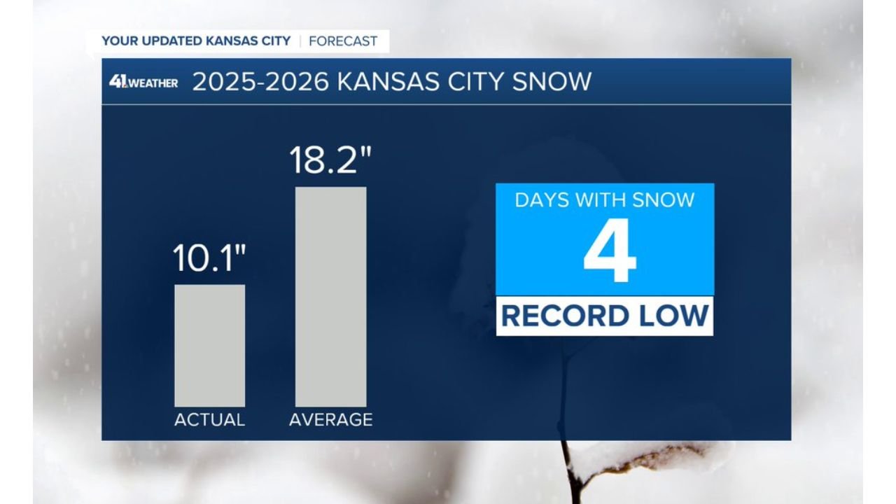
One of the Least Snowy Winters Ever Recorded
While temperature swings grabbed attention, snowfall data tells a completely different story.
- Total snowfall so far: 10.1 inches
- Seasonal average: 18.2 inches
- Days with measurable snow: Just 4 days — a record low
This places the current winter among the least snowy seasons in Kansas City history, with snowfall totals far below normal.
The lack of snow has been driven by:
- Warmer-than-average temperature patterns
- Storm tracks frequently missing the region
- More rain events instead of snow during key systems
A Rare Combination of Extremes
What makes this situation especially unusual is the contrast between the two records:
- Near-record warmth and lack of snow
- Sudden, extreme cold snaps producing historic drops
This combination highlights the increasing variability in Midwest weather patterns, where conditions can swing from one extreme to another in a very short time.
Why Midwest Weather Is So Volatile
Kansas City sits in a region where competing air masses frequently collide:
- Warm, moist air flows north from the Gulf of Mexico
- Cold, dry Arctic air pushes south from Canada
When strong systems move through, these air masses can shift rapidly — leading to:
- Sharp temperature drops
- Intense wind chill swings
- Rapid changes in precipitation type
In this case, a powerful cold front likely drove the dramatic drop, replacing mild air with much colder conditions almost overnight.
What This Means Moving Forward
Despite the recent cold blast, the overall winter trend remains clear:
- Snowfall is significantly below normal
- Cold air is arriving in short, intense bursts rather than sustained periods
- Temperature volatility remains high
Forecasters say additional swings are possible as the season transitions toward spring.
Bottom Line
Kansas City is experiencing a rare and striking weather pattern:
- A 71°F feels-like temperature drop ranking among the largest on record
- Only 4 days with measurable snow, marking a record low
- Total snowfall far below seasonal averages
This unusual mix of extremes is a reminder of how unpredictable and dynamic Midwest weather can be.
Stay with WaldronNews.com for continued updates as these evolving weather patterns continue to impact Missouri and the central United States.