
Texas, Midwest, and Great Lakes Hit by Rare March Weather Chaos as Blizzard, Severe Storms, Fire Danger, and Coastal Alerts Collide Nationwide
UNITED STATES — A sprawling and highly unusual multi-hazard weather pattern is unfolding across the country, with nearly every region facing a different threat — from blizzard conditions in the Upper Midwest to wildfire danger in the Southwest and severe storms across the South.
Meteorologists say this is a textbook example of why March is one of the most volatile weather months in the United States, with winter and spring colliding at full force.
Midwest and Great Lakes Facing Blizzard and Winter Storm Conditions
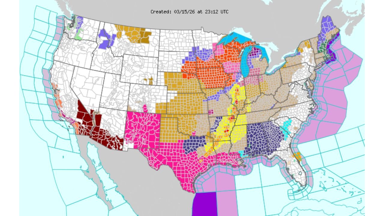
A large swath of the Upper Midwest, including Minnesota, Wisconsin, and parts of Michigan, is under significant winter weather alerts.
- Blizzard warnings and heavy snow are impacting northern areas
- Strong winds are creating whiteout conditions
- Travel conditions are rapidly deteriorating in some regions
At the same time, surrounding states are under winter weather advisories, showing just how widespread the cold side of this system is.
Severe Storm Threat Stretching from Texas to the Mississippi Valley
On the warmer side of the system, a dangerous severe weather corridor is developing.
- Texas, Louisiana, Arkansas, Mississippi, and Alabama are under elevated severe storm risks
- A concentrated zone through the Mississippi Valley is highlighted for stronger storm potential
These storms could bring:
- Damaging winds
- Large hail
- Possible tornadoes
This setup is being fueled by warm, moisture-rich air surging north from the Gulf of Mexico.
Fire Weather Danger Expands Across the Southwest
In stark contrast to the storms and snow, parts of the Southwest — including Arizona and New Mexico — are under critical fire weather conditions.
- Dry air and strong winds are increasing wildfire risk
- Vegetation in these regions remains highly susceptible to ignition
- Any spark could lead to rapid fire spread
This adds another layer of complexity to an already dynamic national weather picture.
Central U.S. Caught in a Transition Zone
States across the Central Plains and Mid-Mississippi Valley are experiencing a mix of hazards:
- Rain and thunderstorms
- Rapid temperature swings
- Shifting wind patterns
This region sits at the battleground between cold northern air and warm southern air, leading to rapidly changing conditions.
Coastal Alerts Add to the Nationwide Impact
Along both coasts, additional hazards are in play:
- East Coast: Marine warnings and coastal advisories are active, particularly offshore
- Gulf Coast: Ongoing marine hazards and storm-related impacts continue
- West Coast: Some localized alerts tied to unsettled conditions
These coastal risks highlight how far-reaching this system truly is.
Why This Pattern Is So Unusual
While each of these hazards can occur individually, what makes this event stand out is the simultaneous overlap of multiple high-impact threats across the country.
- Blizzard conditions in the north
- Severe storms in the south
- Fire danger in the southwest
- Coastal hazards on both sides
This kind of nationwide spread is rare and underscores the complexity of the current atmospheric setup.
What to Expect Next
As the system continues to evolve:
- The storm track will push eastward, shifting impacts into the Ohio Valley and East Coast
- Severe weather threats may expand further into the Southeast
- Cold air will continue to dominate northern regions
Conditions will remain highly dynamic, with rapid changes possible depending on how the system progresses.
Bottom Line
The United States is experiencing a coast-to-coast weather clash, with multiple hazards unfolding at the same time:
- Blizzard conditions in the Midwest
- Severe storms from Texas to the Southeast
- Fire weather risks in the Southwest
- Coastal alerts along both shorelines
This is a powerful reminder of how unpredictable and extreme March weather can be.
Stay with WaldronNews.com for continued coverage as this complex and high-impact weather system moves across the nation.