
Snow Fading Across Pennsylvania and New York Tonight but Lake Effect Bands Near Buffalo and Syracuse Could Still Cause Sudden Travel Issues
PENNSYLVANIA — Scattered snow showers are gradually tapering off across parts of the Northeastern United States this evening, but radar imagery may still appear more intense than actual ground conditions. Despite pockets of snow, most areas are seeing limited impact due to slightly warmer pavement temperatures, with only localized bursts and lake effect bands posing concern in parts of Pennsylvania and New York.
Snowfall Appears Strong on Radar but Ground Reality Less Severe
Current conditions across the region show widespread light snow on radar, stretching from western Pennsylvania through upstate New York and into parts of New England. However, forecasters note that:
- Radar returns are overestimating snowfall intensity in many areas
- Actual accumulation on the ground remains limited in several locations
- Snow is often melting on contact, especially on treated or warmer surfaces
This disconnect is largely due to marginal temperatures near the surface.
Pavement Temperatures Staying Just Above Freezing
One of the biggest factors reducing impacts is that road and pavement temperatures are lingering just above freezing across much of Pennsylvania, New York, and surrounding areas.
This results in:
- Reduced snow accumulation on major roads
- Mostly wet or slushy conditions instead of icy travel
- Lower risk for widespread travel disruptions
Even in areas where snow is falling steadily, the ground conditions are preventing significant buildup.
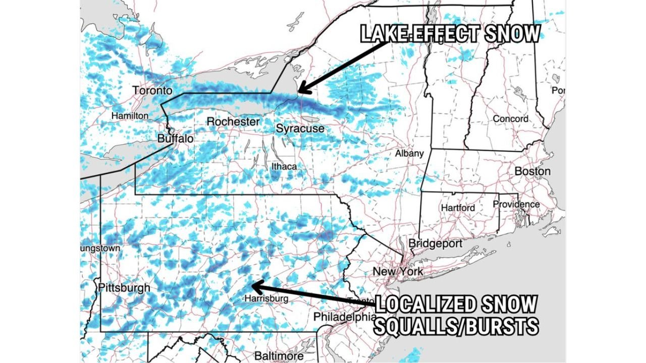
Lake Effect Snow Continues to Target Upstate New York
While general snow is weakening, lake effect snow bands remain active east of Lake Erie and Lake Ontario, particularly impacting:
- Buffalo and western New York
- Rochester to Syracuse corridor
These bands are more focused and can still produce:
- Brief periods of heavier snowfall
- Reduced visibility
- Localized travel impacts
Lake effect snow is being driven by cold air moving across the relatively warmer lake waters, enhancing snowfall in narrow corridors.
Localized Snow Squalls Still Possible in Pennsylvania
Across parts of Pennsylvania, especially central and western areas, localized snow squalls or bursts remain possible through the evening.
These could bring:
- Sudden drops in visibility
- Quick coatings of snow in isolated spots
- Brief but sharp travel hazards
However, these impacts are expected to remain short-lived and highly localized.
Impacts Remain Limited but Drivers Should Stay Alert
Overall, this event is not expected to bring widespread disruption, but conditions can still vary significantly over short distances.
Key takeaways:
- Snow is gradually tapering off across the Northeast
- Warmer pavement temperatures are limiting accumulation
- Lake effect snow remains the primary concern in parts of New York
- Localized squalls may still affect portions of Pennsylvania
Drivers should remain cautious, especially in areas experiencing heavier bursts or lake effect bands where conditions can change rapidly.
What to Expect Next
As the system continues to weaken, conditions will improve overnight with decreasing snow coverage. Any lingering snow showers will become more isolated, with lake effect activity gradually diminishing as well.
Residents across Pennsylvania and New York can expect improving travel conditions, though brief hazards may still occur in localized areas.
Stay with WaldronNews.com for continued updates on changing weather conditions across the Northeast.