
California, Hawaii, Arizona and New Mexico Face Intensifying Pacific Warming as El Niño Signals Strengthen and Forecasters Warn of Major Summer Weather Shifts
UNITED STATES — New ocean temperature guidance is reinforcing what meteorologists have been watching for weeks: the Pacific Ocean is warming rapidly, and signs increasingly point toward El Niño development later this year.
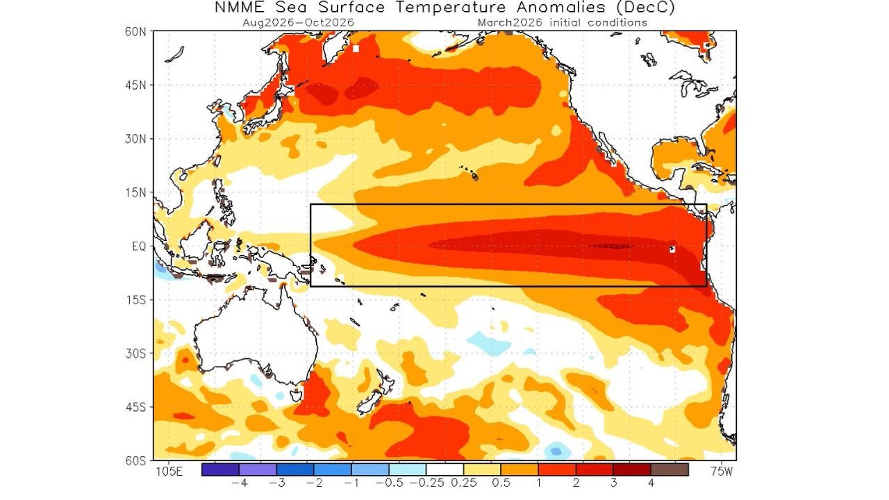
Fresh model projections show widespread sea surface temperature anomalies stretching across the North Pacific and intensifying along the equatorial Pacific — the classic region associated with El Niño formation.
North Pacific Running Well Above Average
The latest sea surface temperature anomaly outlook highlights:
- Broad areas of warmer-than-normal water across the North Pacific
- Expanding warmth from near Japan eastward toward the West Coast of North America
- Significant positive anomalies extending toward Hawaii
This warming has already influenced winter weather patterns across parts of:
- California
- Hawaii
- Arizona
- New Mexico
Several of these regions have experienced periods of above-average rainfall combined with unusually warm winter temperatures — in some cases 15 to 25 degrees above normal.
El Niño Signals Emerging in the Equatorial Pacific
The boxed equatorial region in the projection shows a strengthening band of warmer-than-average water stretching westward from the coast of Peru.
That pattern is consistent with El Niño development.
While the event is still evolving, forecasters are noting:
- Sustained warm anomalies along the equator
- Expanding warm pools into the central Pacific
- Model agreement for continued warming into late summer
If this trend continues, El Niño conditions could become more established heading into late 2026.
What This Could Mean for the Southwest
El Niño often alters atmospheric circulation patterns across the Pacific basin.
For the southwestern United States — including:
- Southern California
- Arizona
- New Mexico
— potential impacts can include:
- Increased monsoon moisture variability
- Shifts in tropical system tracks near Baja California
- Enhanced rainfall episodes during certain phases
Some guidance suggests that low-grade tropical systems forming off Mexico could have more favorable trajectories toward the Desert Southwest depending on how the Pacific pattern evolves.
However, meteorologists caution that not all El Niño events behave the same way. Outcomes can vary significantly in intensity and regional impacts.
Hawaii and California Already Feeling Effects
Parts of Hawaii and California have already seen above-average precipitation this past winter season.
At the same time, anomalous warmth has contributed to significant temperature swings across the West.
The current Pacific configuration may be playing a role in those shifts, particularly with the North Pacific basin running warmer than climatological norms.
Could This Influence Hurricane Season?
A developing El Niño can:
- Suppress Atlantic hurricane activity
- Enhance central and eastern Pacific tropical development
- Shift storm tracks
For Baja California and adjacent areas of the Southwest, this could alter how moisture moves northward during tropical events.
That said, hurricane season outlooks remain preliminary this early in the year.
Watching the Months Ahead
The Pacific remains one of the most powerful drivers of global weather variability.
With widespread warming already established and equatorial signals strengthening, forecasters will be closely monitoring:
- Sea surface temperature trends
- Atmospheric coupling patterns
- Wind anomalies across the tropics
If the projected warming holds, the second half of 2026 could feature noticeable weather shifts across California, Hawaii, Arizona and New Mexico.
Stay with WaldronNews.com for continued updates as Pacific warming and El Niño development shape the months ahead.