
Missouri, Illinois, Indiana, Kentucky, Ohio and West Virginia Face Elevated Sunday Severe Storm Risk as CSU and SPC Highlight Ohio Valley Evening Tornado and Hail Potential
UNITED STATES — The latest machine-learning guidance from Colorado State University (CSU) alongside the Storm Prediction Center’s official Day 3 outlook is signaling a growing concern for severe weather across portions of the Mid-Mississippi Valley and Ohio Valley late Sunday into early Monday.
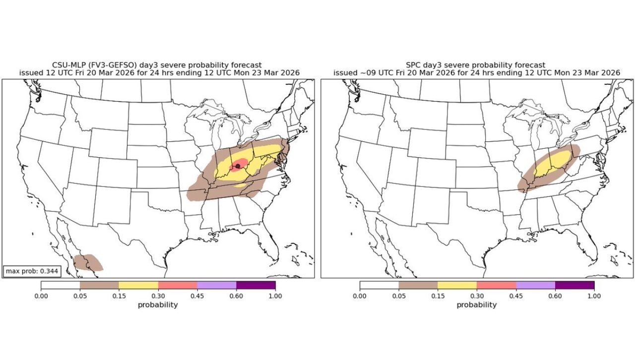
The highest concentration of severe probabilities stretches from Missouri and Illinois eastward through Indiana, Kentucky, Ohio and into West Virginia, with forecasters noting that the most significant threat window appears to be Sunday evening and the early overnight hours.
Core Risk Zone Centered Over the Ohio Valley
The CSU machine-learning probability map highlights a focused corridor of higher severe potential extending across:
- Central and southern Illinois
- Much of Indiana
- Western and central Kentucky
- Southern and central Ohio
- Northern portions of West Virginia
The SPC’s Day 3 outlook similarly outlines a broad severe probability area across the same region, reinforcing confidence that at least scattered strong storms are possible.
Cities within or near the highlighted zone include:
- St. Louis, Missouri
- Indianapolis, Indiana
- Louisville, Kentucky
- Cincinnati and Columbus, Ohio
- Charleston, West Virginia
Timing: Evening and Overnight Threat
Forecasters emphasize that while some storm development could occur during the day, the highest severe potential is expected during the evening and early overnight hours Sunday.
This timing increases concern, as nocturnal severe storms can pose heightened risk due to reduced visibility and sleeping populations.
What Could Limit Development
Meteorologists note that a capping inversion may initially suppress storm development earlier in the day. If that cap holds, severe activity could remain limited.
However, if storms manage to break through the cap — particularly along a frontal boundary — conditions may support stronger storm organization later in the evening.
Primary Hazards: Hail, Wind, and Possible Tornadoes
While detailed hazard probabilities will be refined closer to the event, the setup suggests:
- Damaging wind gusts
- Large hail
- A potential for isolated tornadoes, especially if storms can organize into supercells or line segments
The overlap between CSU’s probabilistic output and the SPC’s official forecast increases confidence that the Ohio Valley should monitor updates closely through the weekend.
Broader Context Across the Central U.S.
This developing severe weather threat comes amid a volatile early spring pattern across the central United States, with strong temperature contrasts and active frontal systems contributing to instability.
The corridor from Missouri through West Virginia sits in a climatologically favored region for early-season severe weather, particularly when warm, moist air surges northward ahead of advancing systems.
What Residents Should Do
With several days remaining before the event, forecast details may shift. However, residents in:
Missouri, Illinois, Indiana, Kentucky, Ohio and West Virginia
should review severe weather safety plans and ensure they have multiple ways to receive alerts, especially given the evening and overnight timing.
Additional updates from the Storm Prediction Center are expected as Sunday approaches.
Stay with WaldronNews.com for continuing coverage and refined outlooks as this potential Ohio Valley severe weather setup evolves.