
Texas, Oklahoma, Arkansas, Missouri, Illinois, Indiana and Kentucky Eye March 31–Early April Severe Weather Threat as Ensemble Models Signal Strengthening Tornado Pattern
UNITED STATES — A potentially active severe weather period is beginning to take shape for March 31 through the first week of April, with multiple forecast models pointing toward a strengthening storm pattern across the central and eastern United States.
New ensemble guidance and machine-learning severe outlooks are increasingly highlighting portions of Texas, Oklahoma, Arkansas, Missouri, Illinois, Indiana, Kentucky and surrounding states as areas to watch for organized thunderstorm activity — including emerging tornado probabilities.
StormNet and Ensemble Guidance Show Expanding Signal
Recent StormNet tornado probability output indicates greater-than-1% tornado probabilities beginning to appear across parts of the southern Plains and Mid-Mississippi Valley.
While 1% may sound small, in medium-range forecasting it represents a meaningful early signal — especially this far in advance. The shaded probability zone stretches from:
- Eastern Texas
- Central and eastern Oklahoma
- Western and central Arkansas
- Southern Missouri
- Portions of Illinois, Indiana and Kentucky
This corridor aligns with climatologically favored late-March severe weather regions.
Upper-Level Pattern Turning More Favorable
Ensemble 500 mb height and wind forecasts show a strengthening trough digging into the western United States while a broad southwesterly jet stream extends across the Plains and Mississippi Valley.
Key features emerging in the data include:
- Increasing mid-level wind speeds over the central U.S.
- Strong southwesterly flow spreading into the Midwest
- A pattern supportive of large-scale ascent and frontal boundaries
This type of configuration is often associated with organized severe weather episodes, especially when combined with adequate moisture return.
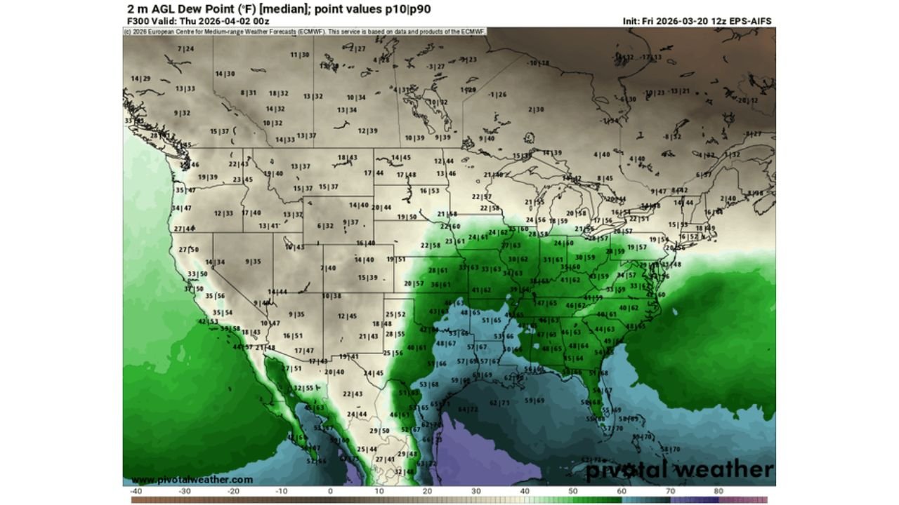
Gulf Moisture Beginning to Expand Northward
Dew point forecasts indicate richer Gulf moisture spreading northward from:
- Coastal Texas
- Louisiana
- Into Arkansas, Mississippi, and Alabama
- Potentially reaching into the Mid-South and lower Ohio Valley
Moisture availability will be a key factor in determining how robust the severe threat becomes. Current projections suggest sufficient low-level moisture could overlap with strengthening wind fields by early April.
Where the Risk Could Focus
At this range, exact storm corridors remain uncertain. However, overlapping model signals suggest a broad zone of interest from:
North Texas and Oklahoma northeastward through Arkansas and Missouri into Illinois, Indiana and Kentucky.
If trends continue, this region could see multiple rounds of thunderstorm development as disturbances move along the jet stream.
Why This Period Matters
Late March and early April represent the climatological ramp-up phase for tornado season across the southern Plains and lower Mississippi Valley.
The combination of:
- Strengthening upper-level flow
- Northward moisture return
- Surface frontal boundaries
- Increasing instability
creates an environment that historically supports severe weather outbreaks.
While no specific outbreak is guaranteed, the consistency across multiple ensemble runs is noteworthy.
What Happens Next
Forecast confidence will improve as the event window draws closer. Details regarding exact timing, storm modes, and hazard types will become clearer over the next several days.
For now, residents in Texas, Oklahoma, Arkansas, Missouri, Illinois, Indiana and Kentucky should remain aware that the pattern is trending more active as March transitions into April.
Stay with WaldronNews.com for continued updates as the early spring severe weather signal evolves.