
Texas, Oklahoma, Kansas and Missouri Roast Under Dominant Western Ridge While New York and New England See Only Fleeting Cool Shots as East Coast Storm Track Shifts Inland
UNITED STATES — A powerful western ridge and eastern trough pattern is once again shaping weather across the country — but this time, the structure of that ridge is dramatically altering the outcome for the East Coast.
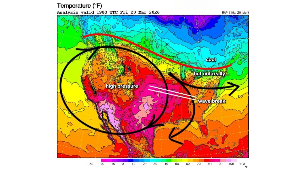
Instead of carving out a deep coastal storm track like late February’s blizzard setup, the current configuration is flattening the eastern trough and shunting the cold air farther north and west. The result: intense warmth across the Plains and Midwest, with only brief, muted cool spells in the Northeast.
High Pressure Dominates the West and Central U.S.
Temperature analysis valid Friday evening shows a massive dome of high pressure centered over the western and central United States, encompassing:
- Texas
- Oklahoma
- Kansas
- Colorado
- New Mexico
- Arizona
- Missouri
Widespread readings in the 70s, 80s, and even 90s are entrenched across the southern Plains and Desert Southwest. This expansive ridge is acting as a heat pump, compressing and warming air across the interior.
The thermal core stretches from northern Mexico through Texas and into parts of the central Plains — a classic signature of a dominant ridge.
Wave Break Prevents Deep Eastern Trough
While a trough is present over the eastern U.S., it is notably flatter and less amplified than earlier winter systems.
A “wave break” in the jet stream is preventing the eastern trough from digging sharply southward along the coast. Instead of locking in a prolonged cold regime for the Mid-Atlantic and Northeast, the pattern favors:
- Short-lived cool taps
- Faster-moving systems
- Storm tracks displaced farther inland rather than hugging the coast
This shift dramatically reduces the potential for repeat coastal blizzard conditions.
Northeast: Cooler, But Not Arctic
Temperatures across:
- New York
- Pennsylvania
- Massachusetts
- Vermont
- New Hampshire
- Maine
are cooler relative to the central U.S., but not deeply frigid. Instead of Arctic air flooding the region, readings remain seasonable to slightly below normal — nothing like the sharp digs needed for a classic Nor’easter.
The cool air remains tucked more north and west, with stronger cold pooling confined closer to eastern Canada.
Why the Structure Matters
Meteorologists emphasize that not all west ridge/east trough setups are created equal.
A “tucked-in” ridge over the West typically allows a deeper eastern trough to carve southward, opening the door for coastal storm development. In this case, however, the ridge orientation and wave break are:
- Limiting how far south cold air can penetrate
- Flattening the jet stream across the eastern states
- Steering storm systems inland instead of offshore
That structural nuance is the difference between a major coastal winter storm and a more inland-driven thermal clash system.
What This Means Going Forward
With high pressure dominating much of the central U.S., warmth is likely to persist across:
- The Southern Plains
- The Midwest
- Portions of the lower Mississippi Valley
Meanwhile, the Northeast may continue to experience passing cool shots but without sustained Arctic outbreaks.
This evolving pattern reinforces a key lesson of transitional seasons: the placement and shape of ridges and troughs matter just as much as their existence.
Stay with WaldronNews.com for continued analysis as the spring pattern continues to reshape the national weather landscape.