
Australia’s Gulf of Carpentaria Watches Cyclone Narelle Intensify to Category 2 as Rare Major Cyclone History Looms Over Northern Territory and Queensland
OKLAHOMA CITY, OK — Two dates in May 2024 — May 6 and May 25 — may ultimately be remembered as some of the most volatile tornado setups in recent Plains history that did not fully realize their catastrophic potential.
Meteorologists reviewing the data say both days featured atmospheric environments capable of producing long-track, violent tornadoes across Oklahoma, southern Kansas and parts of North Texas, rivaling some of the most dangerous setups seen since May 20, 2019.
May 6: High Risk Centered on Central Oklahoma
Forecast maps from early May 6 show a pronounced high-end severe weather corridor stretching across central Oklahoma into southern Kansas.
The most concerning zone included:
- Oklahoma City
- Enid
- Stillwater
- Tulsa
- Lawton
- Wichita, Kansas
- Hutchinson, Kansas
A large red-shaded moderate risk area surrounded an even more intense core across central Oklahoma. The highest tornado probabilities were centered near Enid, Stillwater, and Oklahoma City, highlighting the serious concern for potentially strong tornadoes.
Despite some limiting factors — described by meteorologists as environmental “flaws” — very strong tornadoes still developed. However, the overall outcome was less catastrophic than the environment initially suggested was possible.
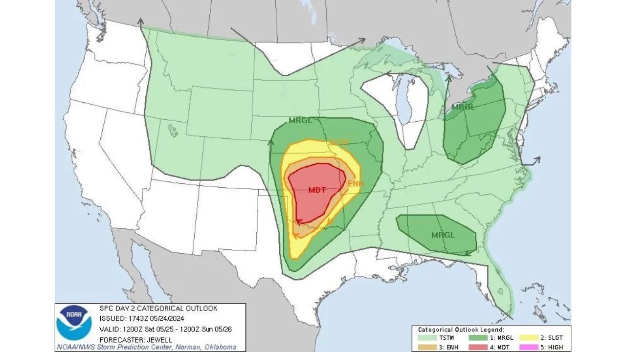
May 25: Moderate Risk Across Oklahoma and North Texas
By May 25, attention again turned to the southern Plains. The Storm Prediction Center’s categorical outlook showed a moderate risk (MDT) area covering much of:
- Central and western Oklahoma
- North and western Texas
- Portions of southern Kansas
Surrounding that moderate zone was an enhanced risk stretching across:
- Arkansas
- Missouri
- Parts of the Lower Mississippi Valley
The setup featured a broad area of instability and wind shear supportive of supercells capable of producing significant tornadoes.
While tornadoes did occur and some were strong, forecasters later noted that the overall environment was “absolutely insane” in terms of potential — suggesting the outbreak could have been substantially worse had atmospheric details aligned more perfectly.
A Rare High-End Environment With Imperfections
Both events shared a similar narrative:
- Extreme instability
- Strong wind shear
- Favorable storm rotation profiles
- But subtle limiting factors that prevented a worst-case scenario
These “flaws” — whether related to storm mode, storm interactions, or cap strength — ultimately tempered the magnitude of destruction.
Still, meteorologists emphasize that very strong tornadoes did form, underscoring how volatile the setups truly were.
Comparison to May 20, 2019
The reference point for many forecasters is May 20, 2019, another powerful Plains severe weather day.
Analysts now suggest that May 6 and May 25, 2024 may rank among the biggest “bullets dodged” in the Plains since that 2019 event — days where atmospheric potential exceeded the realized disaster.
Why These Days Matter
For communities across Oklahoma City, Enid, Stillwater, Wichita, and North Texas, the takeaway is clear:
Even when a worst-case scenario does not unfold, high-end tornado environments remain extremely dangerous and unpredictable.
Meteorologists say these events serve as reminders that preparedness cannot hinge on outcome alone. The atmosphere can produce violent tornadoes even when certain ingredients are imperfect.
As peak severe weather season continues across the Plains, emergency managers and residents alike are urged to stay weather-aware — because sometimes the most significant events are the ones that almost were.
Stay with WaldronNews.com for continuing coverage of severe weather patterns impacting the Southern Plains and beyond.