
Enhanced Risk Severe Weather Outbreak Targets Chicago, Milwaukee, Detroit and Des Moines Tuesday With Giant Hail and Strong Intense Tornadoes Possible as Moderate Risk Was Considered for the Midwest
CHICAGO, Illinois — A dangerous severe weather and tornado outbreak is still forecast to unfold this afternoon and evening across a massive corridor of the Midwest and Plains — with the Enhanced Risk — Level 3 out of 5 now covering a broad zone that includes Chicago, Milwaukee, Detroit, Des Moines, Grand Rapids, La Crosse, and Indianapolis while forecasters confirm that a Level 4 Moderate Risk was seriously considered but held back due to remaining uncertainty in storm mode and coverage.
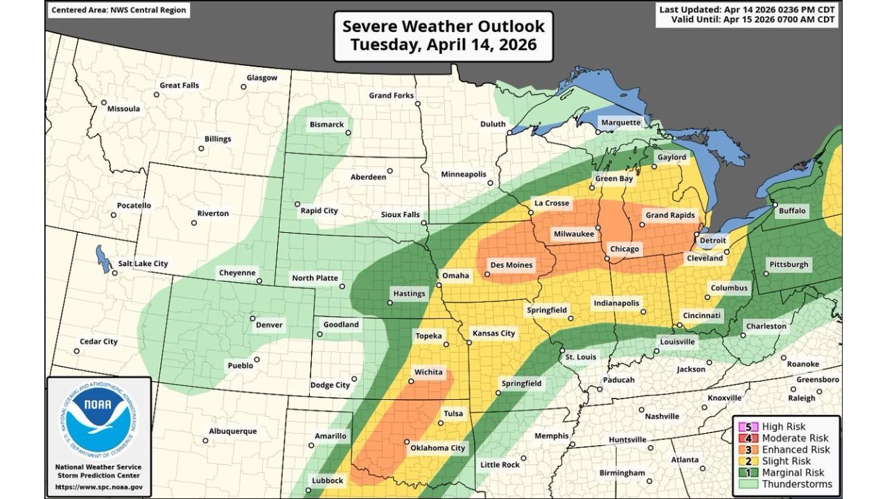
Make no mistake about what that means — the atmosphere today is loaded enough that a Moderate Risk designation was on the table, and the potential for very large to giant hail and strong to intense tornadoes remains fully intact regardless of the final risk level assigned. The Severe Weather Outlook valid Tuesday, April 14, 2026 through 7:00 AM CDT Wednesday — last updated at 2:36 PM CDT — shows the most dangerous corridor centered directly over the Chicago through Milwaukee through Detroit corridor with an additional separate severe threat across the Plains from Wichita through Oklahoma City.
The Full Risk Zone — Level by Level
Enhanced Risk — Level 3 — Orange Zone: The highest risk designation on today’s map covers a sweeping and densely populated corridor:
- Wisconsin: Milwaukee, La Crosse, Green Bay, and the broader southern and central Wisconsin corridor
- Illinois: Chicago and the entire northern Illinois metro area
- Michigan: Detroit, Grand Rapids, and the western and southern Michigan corridor
- Iowa: Des Moines sits inside the Enhanced Risk zone
- Indiana: Indianapolis falls within the Enhanced Risk corridor
- Ohio: Cleveland and the northern Ohio corridor are inside the orange zone
Slight Risk — Level 2 — Yellow Zone: Surrounding the Enhanced core and covering millions of additional residents:
- Minnesota: Minneapolis and surrounding communities
- Iowa — Broader: Omaha corridor and eastern Nebraska
- Illinois — Central and Southern: Springfield, St. Louis fringe communities
- Indiana — Southern: Louisville corridor
- Ohio — Broader: Columbus, Cincinnati on the southern fringe
- Kansas: Topeka and Wichita sit inside the yellow Slight Risk zone
- Oklahoma: Oklahoma City and Tulsa — the separate Plains severe threat corridor
Marginal Risk — Level 1 — Green Zone: The outermost risk area stretches from the Dakotas and Nebraska through Kentucky and Tennessee into Arkansas, Mississippi, and Alabama — confirming the enormous geographic footprint of today’s severe weather pattern.
Why a Level 4 Moderate Risk Was Seriously Considered
The fact that forecasters explicitly considered and nearly issued a Level 4 Moderate Risk for today’s Midwest corridor is one of the most alarming details in this entire outlook. A Moderate Risk designation is issued only when forecasters have high confidence in a significant, widespread severe weather outbreak with multiple long-track tornadoes and/or widespread destructive hail. It is issued on average only a handful of times per year across the entire country.
The reason it was held back — not because the atmosphere is not loaded enough, but because storm mode and coverage remain uncertain. Two specific scenarios could play out:
If storms develop as discrete, separated supercells, today’s atmospheric environment fully supports a Moderate Risk event — with long-track, violent tornadoes and giant hail producing supercells tracking across the Chicago, Milwaukee, Detroit, and Des Moines corridor.
If storms upscale too quickly into a messy cluster or squall line, the tornado threat decreases while damaging winds and large hail remain significant. This is the scenario that kept the designation at Enhanced rather than Moderate — but it is a fine line, and conditions are still evolving.
Regardless of which scenario unfolds, the bottom line is explicit and unambiguous — very large to giant hail and strong to intense tornadoes remain possible across the Enhanced Risk zone.
Two Separate Threats — Midwest and Plains
Midwest Threat — Chicago, Milwaukee, Detroit, Des Moines: The primary and most dangerous threat today is centered on the Enhanced Risk zone across the northern Midwest. This is where the highest instability, the most concentrated low-level wind shear, and the greatest tornado-producing potential are all focused this afternoon and evening. Every community inside the orange Enhanced zone — from Des Moines and La Crosse in the west through Chicago, Milwaukee, and Grand Rapids to Detroit and Cleveland in the east — faces a genuine and serious severe weather threat this afternoon.
Plains Threat — Wichita, Tulsa, Oklahoma City: A separate and distinct severe weather corridor exists across the Southern Plains today — with Wichita, Tulsa, and Oklahoma City all sitting within the yellow Slight Risk zone as a separate dryline-driven storm system operates simultaneously across Kansas and Oklahoma. Supercells developing along the dryline in this region could also produce large hail and tornadoes as the afternoon progresses — making today a truly multi-region severe weather event across an enormous portion of the central United States.
Giant Hail — The Other Major Threat Today
Beyond tornadoes, very large to giant hail is explicitly identified as a major threat across today’s Enhanced Risk zone. Giant hail — exceeding baseball size at 2.75 inches or larger — is possible in the strongest supercells that develop across the Chicago, Milwaukee, and Des Moines corridor today.
Giant hail falling on the dense urban environments of Chicago and Detroit would cause catastrophic and widespread damage — shattering vehicle windshields across parking lots and highways, punching through roofing materials, and creating dangerous conditions for anyone caught outdoors. The sheer population density of today’s Enhanced Risk zone makes the hail threat potentially one of the costliest aspects of this event in terms of property damage.
What Today’s Outbreak Means for 50 Million Residents
The Enhanced Risk corridor from Des Moines through Chicago, Milwaukee, Grand Rapids, Detroit, and Cleveland encompasses one of the highest population density zones in the entire United States. The simultaneous presence of giant hail and violent tornado potential across this corridor — combined with the near-Moderate Risk atmosphere that forecasters were on the verge of issuing — makes today’s event one of the most significant severe weather threats for the Upper Midwest in recent memory.
For urban residents across Chicago and Detroit specifically — cities where tornado preparedness is often less practiced than in traditional tornado alley communities — today’s outlook demands the same urgency and preparation as any significant tornado outbreak regardless of geographic location.
What Every Resident in the Enhanced and Slight Risk Zone Must Do Now
Chicago, Milwaukee, Detroit, Grand Rapids, Des Moines, Indianapolis, Cleveland:
- You are inside the Level 3 Enhanced Risk — the highest risk designation on today’s map. Identify your shelter location immediately and be ready to move there when warnings are issued
- All vehicles must be under covered parking before afternoon storm development — giant hail will cause catastrophic and instant damage to any vehicle left outdoors
- Ensure weather alerts override Do Not Disturb — storms developing this afternoon and evening may continue into overnight hours
Wichita, Tulsa, Oklahoma City:
- The separate Plains Slight Risk is real and active — monitor the dryline situation closely through the afternoon and have shelter plans in place before storm development begins
Everyone in the Marginal Risk Green Zone:
- Minneapolis, St. Louis, Louisville, Nashville, Little Rock, Birmingham — you are on the outer edge of today’s risk. Keep alerts active and monitor conditions through the evening
Today’s severe weather outbreak across the Midwest and Plains is not a routine spring storm. A Level 4 Moderate Risk was on the table, giant hail and violent tornadoes remain possible, and the atmosphere over Chicago, Milwaukee, Detroit, and Des Moines is as loaded as forecasters have seen across this corridor all spring.
WaldronNews.com will continue providing live updates on today’s severe weather outbreak across the Midwest and Plains and will immediately report tornado warnings, confirmed tornadoes, giant hail reports, and storm damage as the event unfolds through this afternoon and evening.