
Wisconsin, Illinois and Kansas Face EF2 to EF3 Tornadoes and 75 mph Winds Today as Two Separate Outbreak Zones Collide
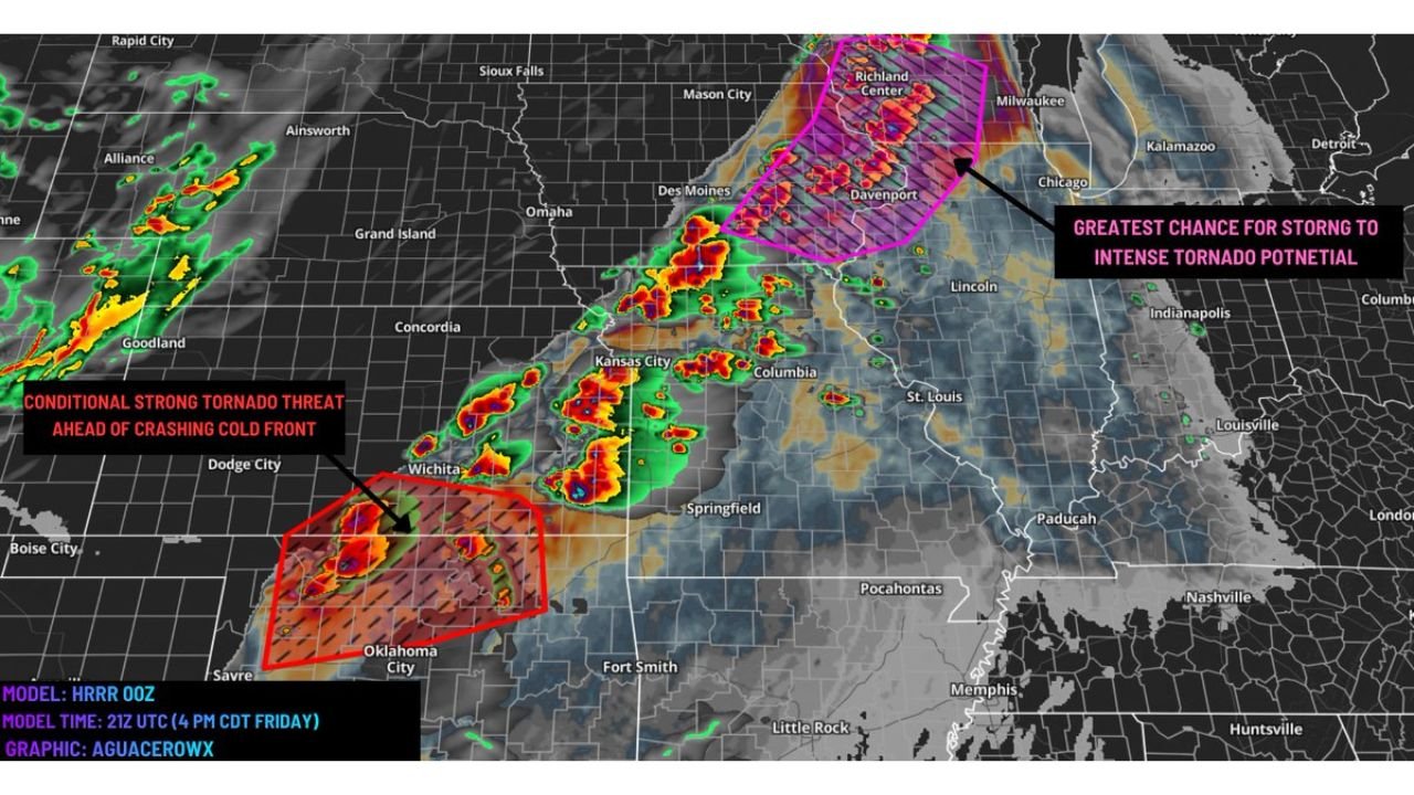
MILWAUKEE, Wisconsin — A extremely volatile atmosphere is locked in across the Upper Midwest today, and the threat arriving this afternoon and evening is as serious as anything seen this spring. Two separate and distinct danger zones are active simultaneously — one centered over Wisconsin, Illinois, and Iowa carrying the greatest chance for strong to intense EF2 to EF3 tornadoes, and a second zone over southern Kansas and Oklahoma where a conditional strong tornado threat is building ahead of a crashing cold front.
Between those two zones, a damaging QLCS squall line is expected to sweep through with winds reaching 60 to 75 mph or higher — meaning virtually no part of the central United States escapes today without a significant severe weather threat of some kind.
Every Area That Faces a Direct Threat Today
- Wisconsin: Milwaukee, Richland Center, Madison, Davenport corridor — sitting inside the magenta hatched zone marked as the greatest chance for strong to intense tornado potential on today’s outlook
- Illinois: Chicago, Davenport, Rockford — on the eastern and southern edge of the primary tornado corridor with EF2 to EF3 potential
- Iowa: Des Moines, Davenport, Iowa City — intense storm cores already showing on radar pushing through the state
- Kansas: Wichita, Dodge City — inside the red hatched conditional strong tornado threat zone ahead of the crashing cold front
- Oklahoma: Oklahoma City and surrounding communities — in the southern conditional tornado zone where supercells could fire ahead of the front
- Missouri: Kansas City, Springfield, Columbia — in the corridor between the two major threat zones where the 60 to 75 mph QLCS winds are expected to sweep through
- Indiana: Indianapolis watching the eastern push of storm activity as the squall line advances through the evening
What Makes This Setup So Dangerous
The atmosphere across the Upper Midwest today is carrying the same ingredients that hammered this exact region on Tuesday — except today the overlap is even more precise and more volatile.
- Extreme CAPE values — extraordinary atmospheric instability overlapping directly with very high wind shear across the Wisconsin-Illinois-Iowa corridor — the exact recipe for EF2 to EF3 supercell tornadoes
- Shear vectors perpendicular to the cold front — this specific orientation allows discrete supercells to stay separated from each other in the early stages, giving each storm room to breathe, organize, and produce tornadoes without interference
- EF2 to EF3 tornado potential explicitly stated for the Richland Center to Milwaukee to Chicago corridor — this is not a marginal or borderline severe weather day
- Hail up to 2 to 3.5 inches or larger — even if the tornado threat does not fully materialize, the hail threat alone across both zones is extreme — stones above 3 inches are softball sized and cause catastrophic property damage
- 60 to 75 mph damaging winds from the QLCS squall line sweeping between the two tornado zones — widespread wind damage expected across Missouri, Kansas, and Indiana
- Conditional strong tornado threat in southern Kansas and Oklahoma — supercells that can hold together ahead of the crashing cold front have a direct path to tornado production as the low-level jet strengthens into the evening
The Critical Uncertainty and Why It Still Demands Full Respect
There is one important factor that forecasters are watching closely today — storm mode. The concern is that storms could grow upscale too quickly, merging into a messier cluster instead of staying as clean discrete supercells. If that happens, the tornado threat decreases somewhat — but the wind and hail threat explodes.
A strong convergence zone forming ahead of the front could cause convection to bubble up rapidly and transition the storm mode from organized supercells to a more chaotic and wind-driven system. Overmixing in the atmosphere is also a possible limiting factor for peak instability.
Here is the bottom line — if storms stay discrete in the Wisconsin-Illinois corridor, EF2 to EF3 tornadoes are the primary threat. If they go messy, 75 mph straight-line winds and softball sized hail become the dominant hazards. Either outcome is dangerous. Either outcome causes significant damage. Today demands full attention regardless of which scenario unfolds.
The Southern Kansas and Oklahoma Window Tonight
While Wisconsin and Illinois deal with the primary tornado corridor this afternoon, the setup in southern Kansas and Oklahoma comes alive in a separate and dangerous way during the evening hours.
Supercells firing along the cold front-dryline intersection in the Wichita to Dodge City to Oklahoma City corridor will be racing against the clock — they need to maintain discrete structure before the cold front crashes into them. The window is narrow but it is real. Any supercell that holds together into the early evening hours, when the low-level jet strengthens, has direct tornado production potential.
Wichita sits at the northern edge of this southern threat zone. Oklahoma City is in the heart of it. The conditional label does not reduce the danger — it simply means the outcome depends on timing that will be decided in real time this afternoon.
What Residents Must Do Right Now
- Wisconsin and Illinois residents — be sheltered before the first storms fire this afternoon — the magenta hatched zone means the highest tornado intensity potential is centered over your communities
- Watch for tornado warnings near Milwaukee, Richland Center, Davenport, and Chicago’s northern suburbs — these are the cities closest to the bull’s eye
- Kansas and Oklahoma residents — evening is your danger window — monitor conditions closely from 6 PM onward as the cold front crashes southward
- Missouri and Indiana communities — the 60 to 75 mph squall line winds sweeping between the two zones will hit with very little warning — secure anything outdoors right now
- Prepare for baseball to softball sized hail — vehicles left outside today across any of the threat zones could sustain major damage
- Do not assume one storm passing means the threat is over — multiple rounds are expected and the atmosphere reloads between waves today
The combination of EF2 to EF3 tornado potential, 75 mph squall line winds, and 3.5 inch hail across three separate states simultaneously makes today one of the most complex and dangerous severe weather days of the entire 2026 spring season.
WaldronNews.com will continue providing live updates on today’s outbreak across Wisconsin, Illinois, Kansas, Oklahoma and all affected states as storms develop and warnings are issued through tonight.