
Colorado and Utah Face 55 mph Wind Gusts Wednesday as Critical Fire Weather Hits Northwest Colorado From Grand Junction to Rifle
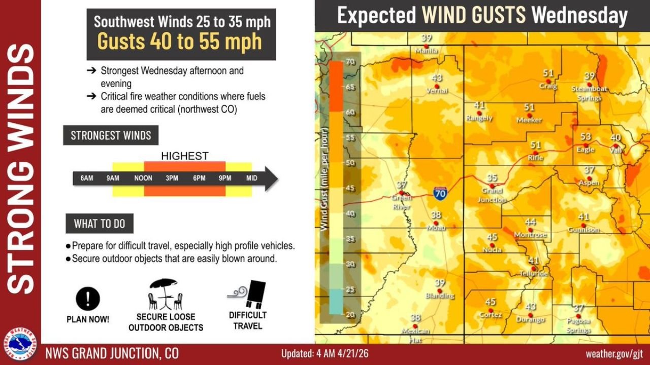
GRAND JUNCTION, Colorado — Strong and dangerous winds are sweeping across western Colorado and eastern Utah today, with southwest winds of 25 to 35 mph and gusts reaching 40 to 55 mph — peak intensity arriving Wednesday afternoon and evening. Northwest Colorado is facing critical fire weather conditions as dry fuels combine with the powerful wind event.
The strongest gusts are expected between 3 PM and 9 PM Wednesday — right during the afternoon heating hours when fire danger is at its highest.
Colorado and Utah Communities in the Wind Zone
Wind gusts of 40 to 55 mph are mapped across a wide area:
- Rifle, Colorado: 51 mph gusts — one of the highest readings in the forecast zone
- Meeker, Colorado: 51 mph gusts — northwest Colorado fire weather concern area
- Grand Junction, Colorado: 35–38 mph gusts in the valley with stronger readings on surrounding terrain
- Montrose, Colorado: 44 mph gusts forecast
- Durango, Colorado: 43 mph gusts in the southwest Colorado corridor
- Vernal, Utah: 43 mph gusts on the Utah side of the border
- Steamboat Springs, Colorado: 39 mph gusts in the northern mountain corridor
- Telluride, Colorado: 41 mph gusts in the San Juan Mountains area
- Aspen, Colorado: 37 mph gusts with difficult travel on mountain roads
Primary Threats Wednesday
The wind event carries multiple distinct dangers:
- Gusts 40 to 55 mph — strongest Wednesday afternoon through evening, peaking between 3 PM and 9 PM
- Critical fire weather — northwest Colorado explicitly flagged where dry fuels combined with 50+ mph gusts create explosive wildfire potential with any ignition source
- Difficult travel for high-profile vehicles — trucks, RVs, trailers, and any tall vehicles face dangerous conditions on I-70 through the Grand Junction corridor and US-50 across western Colorado
- Outdoor hazard — loose objects, patio furniture, signage, and unsecured items become dangerous projectiles in 50+ mph gusts
Why Grand Junction and Northwest Colorado Face the Biggest Risk
Grand Junction, Colorado sits at the heart of a region where Wednesday’s wind event intersects with critical fire weather conditions. Northwest Colorado — covering communities like Rifle and Meeker — is specifically called out as an area where fuels are at critical dryness levels.
When wind gusts hit 50 to 51 mph across terrain covered in dry grass and brush, a single spark — from a vehicle, power line, or any ignition source — can produce a fast-moving wildfire that spreads faster than evacuation can be organized. The combination of 51 mph gusts at Rifle, critically dry fuels, and low humidity creates exactly the conditions that have produced catastrophic wildfires across Colorado in recent years.
The 3 PM to 9 PM peak window is the most dangerous part of the day. Afternoon hours bring the lowest relative humidity and highest temperatures of the day — and now add 50+ mph winds on top of that. Anyone in northwest Colorado with outdoor burning plans, equipment operating in dry vegetation, or any activity that could create a spark should cancel those plans entirely for Wednesday.
For I-70 travelers between Grand Junction and the mountain passes, high-profile vehicle warnings are serious. A 50 mph crosswind gust on an empty straight road is jarring — on a mountain highway with curves and drop-offs it can be lethal. Truckers and RV drivers should consider delaying travel or taking extreme caution through the afternoon and evening hours.
Multi-Day Pattern
Wednesday’s wind event is tied to the same frontal system bringing the dramatic temperature crash to Montana and Wyoming this week. The front’s leading edge pushes strong pressure gradients across Colorado and Utah Wednesday before the system moves east. Thursday brings decreasing winds across western Colorado as the front pushes through, with conditions improving through the day. Friday and the weekend return to more typical spring conditions across the region.
What to Watch Next
- Fire weather watch or red flag warning upgrades for northwest Colorado — Rifle and Meeker corridors
- Wind gust reports Wednesday afternoon — whether 55 mph is exceeded at peak locations
- I-70 high wind advisories and potential restrictions for high-profile vehicles through the Grand Junction corridor
- Any fire ignition reports from northwest Colorado during the peak wind window Wednesday afternoon
- Thursday wind decrease and when conditions return to normal across western Colorado and eastern Utah
Residents across Grand Junction, Rifle, Meeker, Montrose, and surrounding western Colorado should secure all outdoor objects before Wednesday afternoon, avoid any outdoor burning, and plan travel accordingly if driving a high-profile vehicle.
WaldronNews.com will continue tracking Wednesday’s wind event and fire weather threat across Colorado and Utah and provide updates as conditions develop.