
Kansas, Nebraska and Iowa Brace for Damaging Winds and Very Large Hail Thursday as Tornadoes Possible From Wichita to Omaha
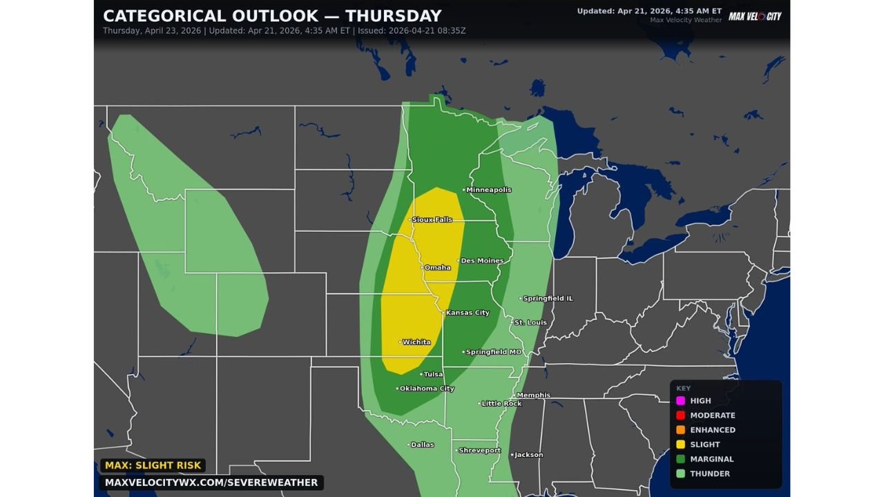
OMAHA, Nebraska — The Great Plains and Midwest are staring down a significant severe weather return on Thursday, April 23 — and the threat corridor is locked in. Damaging winds, very large hail, and tornadoes are all possible across a zone stretching from Oklahoma City through Wichita, Kansas City, Omaha, and up toward Sioux Falls as a powerful storm system charges into the region.
Thursday marks the end of a brief quiet stretch. The atmosphere is reloading fast — and residents from Oklahoma to South Dakota need to be ready.
Cities Directly in Thursday’s Storm Corridor
The Slight to Enhanced risk zone covers a dense population corridor:
- Nebraska: Omaha and Sioux Falls on the northern end — directly inside the yellow Slight Risk zone
- Kansas: Wichita sitting in the heart of the highest risk area Thursday
- Iowa: Des Moines on the eastern edge of the storm corridor
- Missouri: Kansas City in the crosshairs where cold front and dryline energy converge
- Oklahoma: Tulsa and Oklahoma City on the southern end of the active zone
- Minnesota: Minneapolis on the northern fringe of the broader marginal risk area
Primary Threats Thursday
Three distinct dangers are expected with Thursday’s storms:
- Very large hail — the atmosphere is loaded with enough instability to support hail-producing supercells capable of baseball-size or larger hail across Kansas and Nebraska
- Damaging winds — widespread wind damage potential as storms organize along the cold front pushing through the Plains Thursday afternoon and evening
- Tornadoes — isolated tornado potential exists, particularly where discrete supercells can fire ahead of the main line across Kansas, Nebraska, and Iowa
A Different Kind of Threat Than Last Week
Omaha, Nebraska and the surrounding Plains corridor have already been battered this spring — but Thursday’s setup has a distinctly different character than the recent outbreak events. Where last week’s major events featured 45–60% tornado probability with hatched Enhanced Risk zones, Thursday’s threat is more focused on very large hail and damaging straight-line winds as the dominant hazards, with tornadoes as a secondary concern.
That distinction matters for how people prepare. A wind and hail-dominant event means the danger is widespread across the entire storm corridor rather than concentrated in specific tornado tracks. Every community inside the yellow Slight Risk zone from Wichita to Omaha faces a meaningful chance of seeing damaging weather Thursday — not just those directly under a tornado warning.
Very large hail — stones over 2 inches in diameter — destroys vehicles, shatters windows, and damages roofs in minutes. A single severe storm producing baseball-size hail moving across a neighborhood causes more insurance claims than most tornadoes. Wichita and Kansas City sit in terrain where supercells can produce large hail and maintain it all the way to the ground without melting.
The wind threat is equally serious. Storms organizing into a squall line Thursday evening can produce widespread 60 to 70+ mph wind gusts across hundreds of miles simultaneously — knocking out power for large areas and creating dangerous driving conditions.
Multi-Day Pattern
Thursday is the next chapter in what has been an extremely active spring across the Plains and Midwest. After Thursday’s system pushes through, a brief quieter period returns for the weekend. But the overall pattern remains primed for additional severe weather cycles as April closes out and May begins — forecasters are already flagging the late April into early May period as another active window for the same region.
What to Watch Next
- Tornado watch issuances Thursday afternoon for Kansas, Nebraska, and Iowa
- Hail size reports as storms develop Thursday — whether baseball-size hail is confirmed in the Wichita corridor
- Wind damage reports across the Kansas City and Omaha metro areas Thursday evening
- Whether the risk categorical level upgrades from Slight to Enhanced as Thursday approaches
- Friday morning storm report totals covering the full extent of Thursday’s damage
Residents across Kansas, Nebraska, Iowa, and Oklahoma should have severe weather plans ready before Thursday afternoon. Move vehicles into garages or covered parking before storms arrive — hail damage happens fast and without warning once a storm is overhead.
WaldronNews.com will continue tracking Thursday’s severe weather threat and provide updates as the storm system approaches.