
Montana Hits 88 Degrees Tuesday Before Cold Front Crashes Temperatures 50 Degrees and Brings Snow to Billings and Miles City by Thursday
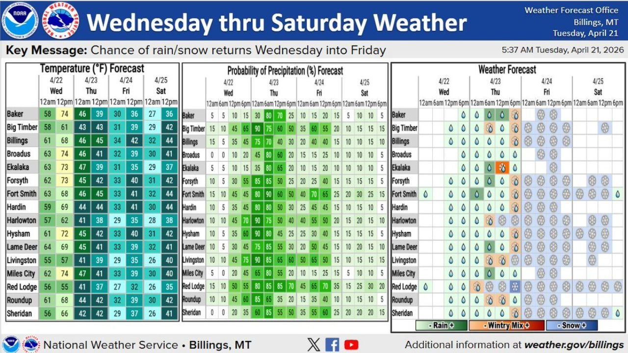
BILLINGS, Montana — Billings, Montana is experiencing a dramatic weather whiplash this week — soaring to 88°F Tuesday with hot, dry conditions across the region before a powerful cold front crashes through Wednesday night, sending temperatures plummeting and flipping the precipitation from rain to snow by Thursday. The temperature swing from Tuesday’s highs to Thursday’s lows represents a drop of nearly 50 degrees in under 48 hours.
From summer-like heat to winter-like cold — all in the same week.
Montana and Wyoming Cities in the Storm’s Path
The cold front impacts a wide swath of south-central Montana and northern Wyoming:
- Billings, Montana: Drops from 88°F Tuesday to a high of just 45°F Thursday — rain and snow Thursday with 75% precipitation probability
- Miles City, Montana: 88°F Tuesday crashing to 41°F Thursday — 80% chance of rain/snow Thursday afternoon
- Big Timber, Montana: Tuesday high of 61°F dropping to 43°F Thursday with 90% precipitation chance — one of the highest probabilities in the forecast
- Livingston, Montana: Temperatures falling to 39°F Thursday with 90% precipitation probability and wintry mix potential
- Harlowton, Montana: Dropping to 38°F Thursday with 90% rain/snow chance
- Red Lodge, Montana: Falling to 37°F Thursday with 85% precipitation probability and snow likely given elevation
- Sheridan, Wyoming: High of 85°F Tuesday tumbling to 42°F Thursday with 85% precipitation chance
- Roundup, Montana: 68°F Tuesday to 42°F Thursday — 85% precipitation probability
Primary Threats Wednesday Night Through Friday
The cold front delivers a multi-day impact sequence:
- Rain to snow transition — precipitation arrives Wednesday night as rain, then flips to snow Wednesday night into Thursday as temperatures crash below freezing at elevation and near freezing in the valleys
- 50-degree temperature crash — Billings and Miles City going from 88°F to the upper 30s and low 40s in under two days is a meteorologically dramatic swing
- 80–90% precipitation probability Thursday for most of the region — this is not a marginal rain chance, this is a high-confidence precipitation event
- Wintry mix — the forecast table shows wintry mix icons for multiple communities Thursday, meaning freezing rain or sleet mixed with snow is possible at some locations
- Friday lingering snow — Red Lodge, Fort Smith, and Sheridan show continued snow chances Friday with 60–70% precipitation probability persisting
Why This Week’s Swing Is So Dramatic for Billings
Billings, Montana hitting 88°F in late April is not unusual for the region — the eastern Montana plains can warm rapidly under southerly flow ahead of approaching systems. But the contrast between Tuesday’s heat and Thursday’s near-freezing temperatures with snow is exactly the kind of volatile pattern that defines late April in Big Sky Country.
The forecast probability numbers tell the story of how confident forecasters are in this event. Big Timber at 90%, Livingston at 90%, Harlowton at 90%, Miles City at 80% — these are not uncertain borderline forecasts. The cold front is coming, the moisture is coming, and the temperature drop is coming. The only question is exactly how much snow accumulates at specific elevations.
Red Lodge is particularly worth watching. Sitting at higher elevation south of Billings, Red Lodge already shows snow icons on both Thursday and Friday with precipitation probabilities holding at 80–85% through Friday evening. Mountain communities and passes in the Beartooth Range will see the heaviest snow accumulation from this system.
For ranchers and farmers across south-central Montana and northern Wyoming, this kind of late April cold snap with precipitation is significant. Livestock that have been out in warm spring conditions face a sudden return to near-winter stress, and any early planting faces frost and freeze exposure through the weekend.
Multi-Day Pattern
Tuesday: Hot and dry across the region — enjoy the upper 80s. Wednesday: Clouds increase, temperatures begin to fall as the front approaches — rain arrives Wednesday night. Thursday: The coldest day of the stretch — temperatures in the 39–46°F range across the region with rain, wintry mix, and snow. Friday: Continued unsettled with snow chances persisting especially at elevation. Saturday: Temperatures slowly moderating back into the 35–44°F range with decreasing precipitation chances as the system moves east.
What to Watch Next
- Snow accumulation totals for Red Lodge and the Beartooth foothills Thursday night into Friday
- Road conditions on US-212 (Beartooth Highway) and I-90 through Livingston and the Yellowstone corridor
- Wintry mix potential for valley communities like Billings and Miles City Thursday morning
- Livestock advisories for south-central Montana ranching communities
- Whether Saturday’s temperatures recover faster or slower than currently forecast
Residents across Billings, Miles City, Livingston, and surrounding Montana and Wyoming communities should be prepared for a dramatic shift from Tuesday’s summer heat to near-freezing precipitation by Thursday. Have winter driving supplies accessible — this front moves fast.
WaldronNews.com will continue tracking Montana and Wyoming’s dramatic temperature crash and winter storm and provide updates as the front approaches.