
Tennessee, Mississippi and Arkansas Face Possible Severe Weather Monday April 27 as Storm Threat Pushes Into Nashville, Memphis and Little Rock
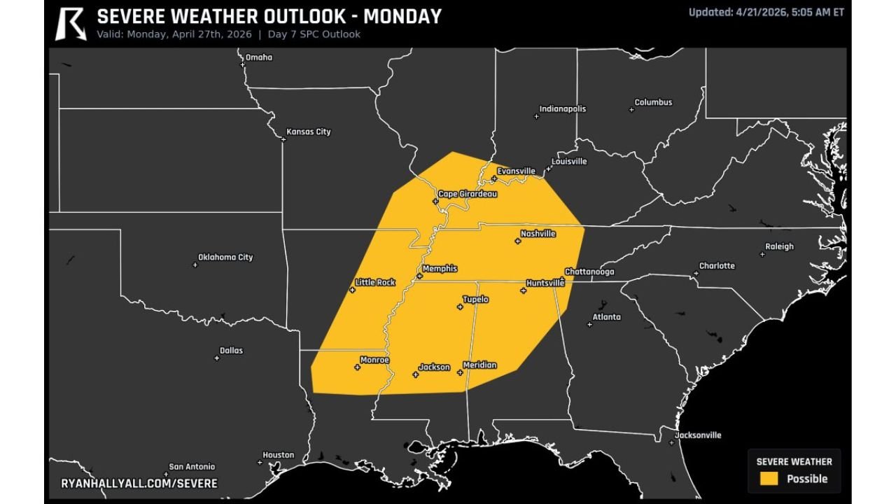
NASHVILLE, Tennessee — Eyes are already turning toward Monday, April 27 — and what forecasters are calling potentially a big severe weather day for the Mid-South and Tennessee Valley. A severe weather threat is now showing up on the Day 7 outlook covering a corridor stretching from Little Rock, Arkansas through Memphis, Nashville, Tupelo, Huntsville, and into southern Illinois — notably the farthest east severe threat seen in this active spring season.
This is early in the forecast cycle, but the signal is significant enough to start watching now.
Cities and States in Monday’s Early Severe Weather Outlook
The yellow severe weather possible zone covers a densely populated corridor:
- Tennessee: Nashville and the entire central Tennessee corridor sitting near the center of the risk zone — Chattanooga on the southeastern edge
- Mississippi: Tupelo, Jackson, and Meridian all inside the outlined threat area
- Arkansas: Little Rock and Monroe in the southwestern portion of the risk zone
- Illinois: Cape Girardeau area and southern Illinois on the northern fringe
- Alabama: Huntsville sitting directly inside the risk zone — northern Alabama in the threat corridor
- Kentucky: Evansville and western Kentucky on the northern edge
- Louisiana: Monroe area included on the southwestern end of the threat
What Makes Monday’s Setup Stand Out
Several factors make this early outlook worth paying close attention to:
- Farthest east severe threat of the season — this setup pushes the severe weather corridor well into the Tennessee Valley and Mid-South, away from the typical Plains and Midwest targets that have dominated spring 2026
- Day 7 outlook signal — the fact that a defined risk area is appearing this far out indicates forecasters have high confidence in the overall pattern, even if specific timing and intensity details remain uncertain
- Nashville and Huntsville in the bull’s-eye — two major population centers sitting directly inside the outlined threat zone
- Different region, same active pattern — the same energetic spring atmosphere that has been hammering the Plains and Midwest all month is now targeting the South and Tennessee Valley
Why Nashville and the Tennessee Valley Need to Watch Monday
Nashville, Tennessee has been on the eastern fringe of several spring 2026 severe weather events — but Monday’s setup brings the threat directly to Music City rather than clipping its western edge. The severe weather possible zone places Nashville near the center of the outlined risk area, meaning the city and surrounding communities face a more direct threat than they have seen this spring.
For Huntsville, Alabama — already dealing with drought stress and the broader Southeast dry pattern — a severe weather event on Monday would be a different kind of threat entirely. Northern Alabama sits in terrain where severe storms can produce all three primary threats: tornadoes, large hail, and damaging winds.
The Memphis, Tennessee corridor connecting Arkansas and Mississippi is also notable. Memphis sits at a geographic crossroads where atmospheric boundaries frequently focus severe weather activity — and with Little Rock on the western end and Tupelo and Jackson to the south, the entire mid-Mississippi Valley corridor is in the early crosshairs.
What forecasters are flagging most is the eastward displacement of this threat. The Plains and Midwest have absorbed outbreak after outbreak this April. Monday’s signal suggests the pattern is shifting the primary action eastward into a region that has seen less direct severe weather — meaning communities in Tennessee, Mississippi, and Alabama may be less mentally prepared for a significant event than their counterparts in Iowa and Kansas who have been on alert all month.
Multi-Day Pattern
Thursday and Friday remain the immediate severe weather focus for the Plains and Midwest. After a brief quieter period this weekend, Monday, April 27 emerges as the next significant severe weather opportunity — this time targeting the South and Tennessee Valley rather than the central Plains. The overall active spring pattern shows no signs of shutting down as April closes out.
What to Watch Next
- Forecast updates over the next 48–72 hours as Monday’s setup comes into better focus
- Whether the risk level upgrades from “possible” to a categorical Slight, Enhanced, or higher risk
- Tornado probability values as they become available for the Nashville and Memphis corridors
- Whether the risk zone expands further east into the Carolinas or contracts westward
- Thursday and Friday storm reports — how well the atmosphere performs this week will give clues about Monday’s potential
Residents across Tennessee, Mississippi, Arkansas, and Alabama should mark Monday, April 27 on their radar now — not to panic, but to be aware. As the forecast sharpens over the next several days, more specific guidance will emerge. Have your severe weather plan ready before the weekend arrives.
WaldronNews.com will continue tracking Monday’s developing severe weather threat and provide updates as the forecast evolves through the week.