
Wichita and Central Kansas Brace for EF2+ Tornadoes Tonight as Supercells Fire After 4 PM
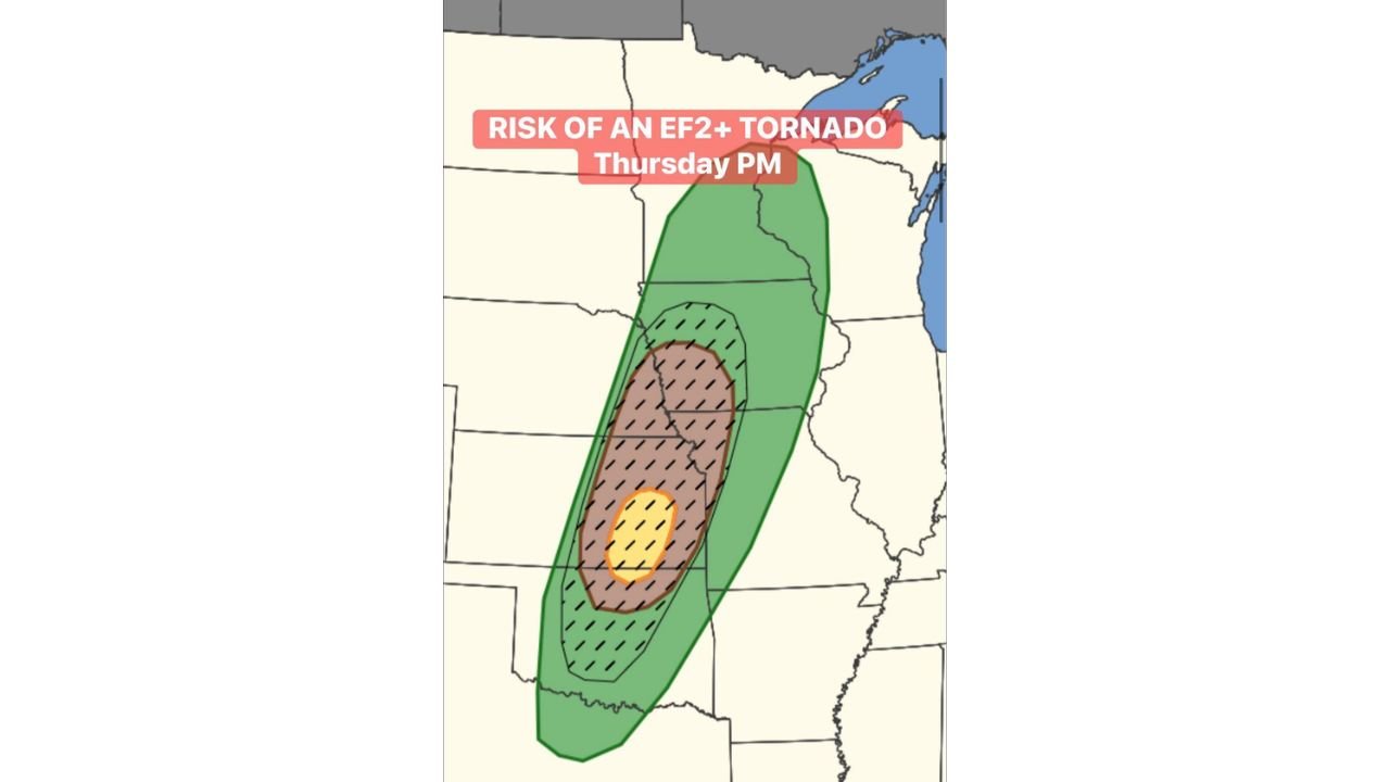
WICHITA, Kansas — The tornado threat across central and eastern Kansas has been officially upgraded this afternoon, with a 10% significant tornado area now in place — meaning the tornadoes that do touch down tonight have a real chance of being EF2 or stronger. Supercells are expected to fire this evening as a low-level jet strengthens during the critical late-afternoon window, turning storms into organized, long-track tornado-producing machines by nightfall.
Wichita and the surrounding central Kansas corridor sit inside the highest-probability bull’s-eye on the map — the yellow core zone where the overlap of instability, shear, and forcing is most dangerous.
States and Cities in the Upgraded Risk Zone
Yellow Core — Highest EF2+ Tornado Risk:
- Kansas: Wichita, Hutchinson, Newton, El Dorado — dead center of the bull’s-eye; EF2+ tornadoes most likely here
Brown Hatched Zone — Significant Tornado Risk:
- Kansas: Salina, Emporia, Manhattan, Dodge City — significant tornado threat; hatching confirms EF2+ potential throughout this zone
- Oklahoma: Ponca City, Enid, northern Oklahoma — southern end of the significant tornado corridor
Green Outer Zone — Tornado and Severe Storm Threat:
- Nebraska: Lincoln, Hastings — tornado possible on the northern fringe
- Missouri: Kansas City, Joplin — outer severe storm threat as system pushes east
- Arkansas: Fayetteville, Fort Smith — on the far southern edge of the green zone
Primary Threats
- EF2+ significant tornadoes — the hatched zone covering most of central and eastern Kansas confirms this is not a marginal setup; strong, long-track tornadoes are the primary concern tonight
- Low-level jet development during the 4–5 PM window — this is the trigger that forecasters have been watching; when the low-level jet blooms this evening, it dramatically amplifies wind shear near the ground where tornadoes form
- Supercell mode — short-range data strongly suggests storms will remain discrete supercells rather than merging into a line, which is exactly the storm type that produces the most violent tornadoes
- Nighttime tornado risk — the low-level jet peaks after dark, meaning tornado-warned storms could be ongoing well into the overnight hours across Kansas and into Missouri
Why This Matters for Wichita and Central Kansas
Wichita is sitting inside the yellow core — the innermost and most dangerous zone on today’s outlook map. That yellow bull’s-eye represents where every ingredient for a significant tornado comes together at once: enough atmospheric instability to fuel explosive storm growth, wind shear that spins storms into supercells, and a low-level jet that arrives right at the time storms are most organized and most dangerous.
The phrase “magic hour” refers to the late afternoon period — roughly 4 to 6 PM — when the combination of daytime heating and strengthening low-level winds creates the most tornado-favorable window of the day. Tonight, that window lines up directly with supercell development over central Kansas. Once those storms get going, the low-level jet keeps feeding them rotational energy into the night.
A 10% significant tornado probability on an outlook map sounds like a small number but it is not. It means that in areas with this designation, roughly 1 in 10 locations within the zone could experience a significant tornado — and with the yellow bull’s-eye sitting over a populated corridor from Hutchinson through Wichita to El Dorado, the stakes are very real for hundreds of thousands of people.
Multi-Day Pattern
Tonight’s upgraded threat is the opening act of a multi-day severe weather stretch across the Plains and Mid-South. After tonight’s Kansas storms move east, attention shifts immediately to Monday, April 27 when Tennessee, Arkansas, and Mississippi face their own significant tornado outbreak. The atmosphere is not resting between events — it is cycling through back-to-back dangerous setups with barely a break in between.
Kansas and Oklahoma have seen multiple active days this week, and tonight represents the peak local threat. But residents in Missouri and Arkansas should begin watching closely as tonight’s storm system tracks east through the overnight hours.
What to Watch Next
- 4 to 5 PM is the critical window — this is when low-level jet development begins and supercells could rapidly become tornado producers across central Kansas
- If you are in Wichita, Hutchinson, or anywhere inside the hatched zone — have your shelter identified and be ready to move immediately when warnings are issued
- Tornado warnings tonight may come with very short lead times as storms move quickly — do not wait to hear a siren before taking action
- Track storm movement toward Kansas City and Missouri for the overnight hours — the threat does not end at the Kansas border
- Monday’s Mid-South outbreak follows immediately — residents in Tennessee and Arkansas should be finalizing their own plans tonight
Tonight is a serious, life-threatening severe weather situation for Wichita and central Kansas — treat every tornado warning as the real thing.
WaldronNews.com will continue tracking tonight’s tornado threat across Kansas and provide live updates as storms develop this evening.