
New York, Ohio and Iowa Frost Risk Arrives May 1 While Minnesota and North Dakota Stay Frozen Through May 21 in the Coldest Start to May in Years
DES MOINES, Iowa — The frost season is not over for a large portion of the country — it is just getting reorganized. A frost risk outlook running through mid-May shows three distinct danger windows rolling across the Northeast, Great Lakes, Midwest, and Northern Plains in sequence, with the coldest and most persistent risk concentrated across Minnesota, North Dakota, and the Northern Plains where temperatures below 36°F are possible through May 21 or later.
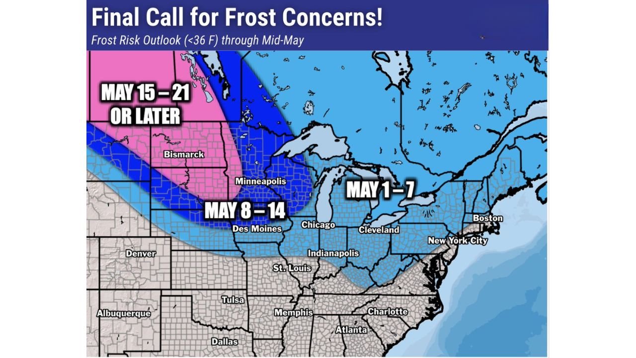
For farmers and gardeners across the Ag Belt, this map is a direct warning that planting timelines need to account for a cold first half of May that is not behaving like a typical spring.
Three Frost Windows, Three Different Regions
The map divides the frost risk into three clearly labeled time periods, each covering a different geographic zone as the cold air pattern evolves through mid-May.
May 1 through 7 — the immediate frost window:
The light blue zone covering May 1-7 is the most geographically broad and the most immediately relevant. It stretches from the Northeast coast through the Great Lakes and down through the Ohio Valley. Cities sitting inside this first frost window include Boston, New York City, Cleveland, Chicago, Indianapolis, Detroit, and Des Moines. This is the cold air intrusion already being signaled in the early May pattern change driven by high pressure building over Greenland and Alaska. Temperatures dropping below 36°F during this window are possible across all of these areas, particularly during the overnight and early morning hours.
May 8 through 14 — the second wave pushes into the Midwest:
The medium blue zone covering May 8-14 shows the frost risk persisting and actually expanding westward and southward into Iowa, Minnesota, Wisconsin, and the Upper Midwest. Des Moines, Minneapolis, and the surrounding agricultural heartland remain under frost threat into the second week of May. This is the window that poses the most direct threat to corn and soybean emergence across Iowa and Illinois, where crops planted in the warm mid-April window will be several weeks into development and increasingly sensitive to cold temperature stress.
May 15 through 21 or later — the final call for the Northern Plains:
The pink zone reserved for May 15-21 or later covers North Dakota, South Dakota, Montana, and portions of Minnesota. Bismarck sits squarely inside this zone. For these northern communities, frost risk is not unusual in mid-May historically, but the persistence of below-36°F temperatures through the third week of May in what is already a cold pattern represents a meaningful agricultural risk for spring wheat and other cool-season crops that are vulnerable to hard freezes even after emergence.
What This Means Specifically for the Ag Belt
The Ag Belt running through Iowa, Illinois, Indiana, Ohio, and Minnesota is the heart of the American corn and soybean production system. The timing of this frost risk map lands at one of the most sensitive moments in the planting calendar. Fields that were planted in mid-to-late April during the record warm stretch are now approaching or entering emergence right as the coldest air of the spring season arrives.
Iowa in particular faces exposure across both the May 1-7 and May 8-14 windows. That is potentially two consecutive weeks of frost threat landing on fields where corn is just beginning to push through the soil surface. Emerged corn seedlings are vulnerable to temperatures below 32°F and can suffer significant damage from extended periods in the mid-30s even without a hard freeze. Two weeks of recurring frost risk is a scenario that agricultural forecasters and crop insurance adjusters watch closely.
Ohio and Indiana sit inside the May 1-7 window with some exposure into May 8-14 depending on how the pattern evolves. Chicago and Indianapolis are in the May 1-7 zone, which aligns with the below-normal temperature anomaly already confirmed in the early May forecast data.
The Northeast Exposure That Often Gets Overlooked
New York City, Boston, and the broader Northeast inside the May 1-7 frost window may surprise some residents who associate frost risk with the Midwest and Plains. Urban heat island effects protect the city cores themselves, but suburban and rural areas of New York, Connecticut, Massachusetts, and Pennsylvania absolutely face frost risk during the first week of May in a cold pattern like this one.
Gardeners across the Northeast who planted warm-season crops like tomatoes, peppers, and basil during the warm late-April stretch face a real risk of frost damage during the first week of May. The map is explicit: below 36°F temperatures are possible across this entire blue zone through May 7.
The Pattern Driving All Three Windows
All three frost windows are products of the same large-scale atmospheric setup: high pressure anchored over Greenland and Alaska simultaneously, forcing the jet stream into a deeply amplified southward buckle through the center of the country. This kind of atmospheric blocking tends to be persistent once established, which is why the frost risk is not a one or two day event but instead a three-week rolling threat that progresses from the Northeast through the Midwest and eventually into the Northern Plains.
The cold air that produces New York City’s May 1-7 frost risk is the same cold air mass that, modified and reinforced by subsequent intrusions, eventually reaches Bismarck still cold enough to produce frost threats in the third week of May.
Anyone farming or gardening between Boston and Bismarck needs to treat the next three weeks as frost-risk territory and plan accordingly.
WaldronNews.com will continue tracking the frost risk outlook through mid-May and provide updates as individual frost and freeze events approach each region.