
NOAA Flags Illinois, Indiana and Michigan for Hazardous Cold May 2 Through 8 as Near-Freezing Lows Threaten Early Blooming Crops Across the Great Lakes
CHICAGO, Illinois — NOAA’s Climate Prediction Center has issued a formal Hazardous Temperature outlook for the period May 2 through 8, placing Illinois, Indiana, Michigan, Ohio, Kentucky, and surrounding Great Lakes states under a Moderate Risk of Much Below Normal Temperatures. The most dangerous cold arrives May 2 through 3 when temperatures across the core zone are forecast to run well below seasonal averages with near-freezing low temperatures possible across the Upper Midwest and Great Lakes — arriving at exactly the moment when early-blooming crops and recently planted fields are most exposed.
This is not a brief overnight cold snap. NOAA’s formal hazardous temperature designation covers a full week and the 6-10 day temperature outlook from April 30 through May 4 shows the highest-confidence below-normal signal centered directly over Illinois, Indiana, Kentucky, and Ohio with 70-80% probability of below-normal temperatures throughout the period.
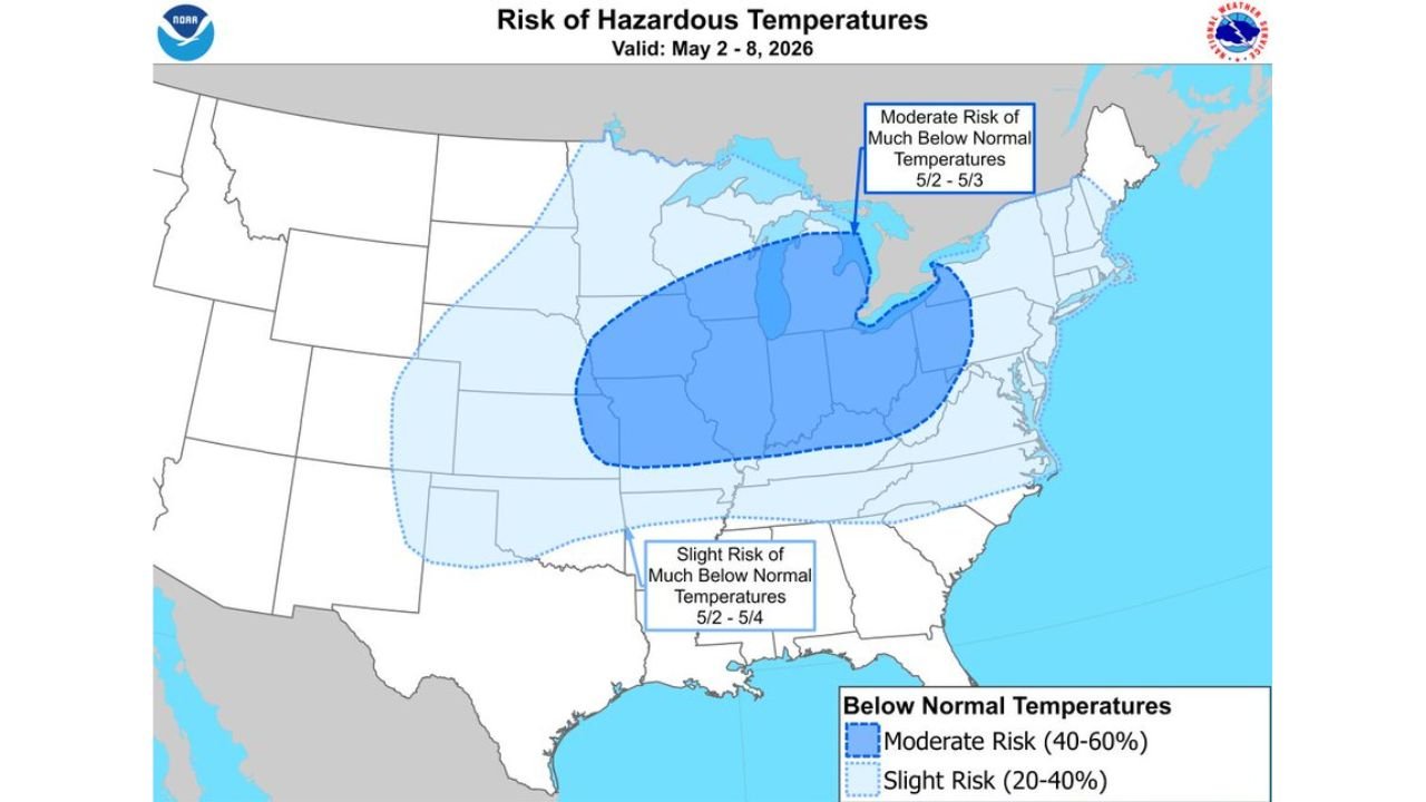
What NOAA’s Hazardous Temperature Map Actually Shows
The Climate Prediction Center’s hazardous temperature product is issued specifically when cold is significant enough to cause damage to agriculture, infrastructure, or human health. Two separate risk zones are drawn on the May 2-8 map.
The Moderate Risk zone in darker blue covers the core cold air target area and includes Michigan, Wisconsin, Illinois, Indiana, Ohio, Kentucky, West Virginia, Pennsylvania, and portions of New York and New Jersey. A Moderate Risk means a 40 to 60% probability of much below normal temperatures during the valid period. The most intense cold arrives May 2 through 3 according to the outlook text, making that the critical 48-hour window for frost and freeze events across this zone.
The Slight Risk dotted zone extends the cold threat much further, reaching south through Tennessee, Arkansas, Mississippi, Alabama, and west across the Southern Plains through Kansas and Nebraska. The Slight Risk indicates a 20 to 40% probability of much below normal temperatures, with the southern portion of this zone most exposed May 2 through 4 as the cold air settles southward over several days.
The 6-10 Day Temperature Outlook Tells the Same Story in More Detail
NOAA’s 6-10 day temperature probability map valid April 30 through May 4 puts hard numbers on what the hazardous temperature outlook describes in categories. The deep blue oval centered over Illinois, Indiana, and Kentucky represents 70 to 80% probability of below-normal temperatures during this five-day window. That is the highest confidence below-normal signal anywhere on the entire continental United States map for this period.
Moving outward from that core, Michigan and Ohio sit at 60 to 70% probability below normal. Wisconsin, Missouri, Tennessee, and Virginia fall in the 50 to 60% range. The broader light blue covering extends from the Dakotas through the Mid-Atlantic, all showing at least a 33 to 50% probability of below-normal temperatures.
Florida is the only area showing above-normal temperatures during this period, with the peninsula holding onto warmth as the cold air stays well to the north.
The Crop Damage Concern NOAA Is Specifically Calling Out
The forecast language attached to this hazardous temperature designation explicitly warns about damage to early blooming crops. This is not generic cold weather language — it reflects a specific concern about the timing collision between the warmest April in modern D.C. records, which pushed crop development and bloom timing weeks ahead of historical averages, and a first week of May that now threatens to deliver near-freezing overnight lows to those same early-stage crops.
Illinois and Indiana corn planted during mid-April’s record warmth may be at or approaching emergence during the May 2-3 cold maximum. Corn seedlings at the VE to V1 stage are particularly sensitive to temperatures below 32°F sustained for more than a few hours, and temperatures in the low 30s even without hard freezing can slow development, reduce stand uniformity, and set yield potential back.
Michigan fruit orchards that bloomed early due to April warmth face the most acute risk. Peach, cherry, and apple blossoms at or past full bloom can be killed at temperatures of 28°F for just 30 minutes. The Moderate Risk zone covering Michigan through May 8 means multiple overnight events with near-freezing potential across the state’s primary fruit production regions in the southwestern Lower Peninsula.
Ohio and Kentucky winter wheat that headed early faces quality and yield risk from cold temperatures at this sensitive growth stage.
The Geography of Who Gets Hit Hardest
The cold air maximum sits over Illinois, Indiana, and Ohio based on both the Hazardous Temperature outlook and the 6-10 day probability map. These three states represent the geographic center of the Corn Belt and are home to millions of acres of recently planted corn and soybeans that have had their growing window compressed by the warm April pattern.
Michigan carries special concern because of the fruit production concentration along Lake Michigan’s eastern shore and because the Great Lakes themselves can create localized cold air pooling during clear, calm nights that drives temperatures several degrees below what surrounding areas experience.
Kentucky and Tennessee are further south but still inside the Moderate Risk zone, reflecting how deeply the cold air mass is forecast to penetrate below the Ohio River during the May 2-3 maximum cold window.
The Week Before and the Week After Tell the Full Story
What makes this hazardous temperature period especially difficult for agriculture is the context surrounding it. The week before brought record warmth and severe weather from the Plains to the Mid-South. The week after shows the cold beginning to moderate but the frost risk extending through mid-May across the Northern Plains per the separate frost risk outlook. Agricultural operations across the Corn Belt are essentially being asked to navigate a rapid swing from historic April warmth to a potentially crop-damaging cold snap within the span of 10 days.
Frost protection measures, replanting contingency plans, and crop insurance documentation should all be priorities for farmers across Illinois, Indiana, Michigan, and Ohio between now and May 8.
WaldronNews.com will continue tracking the hazardous temperature outlook across the Great Lakes and provide updates as frost and freeze advisories are issued through the first week of May.