
Oklahoma, Kansas, Arkansas and Texas Face Giant Hail Up to 3 Inches and 75 mph Winds Saturday With Strong Tornadoes Possible if Boundary Interactions Line Up
TULSA, Oklahoma — Saturday is shaping up as a significant severe weather day across Oklahoma, Kansas, Arkansas, and parts of Texas, with the main story being very large to potentially giant hail. Intense supercells are expected to develop by late afternoon across Oklahoma and Kansas, capable of producing hailstones up to 3 inches in diameter, damaging winds reaching 75 mph, and a few tornadoes. If storms interact favorably with surface boundaries during development, a strong tornado or two cannot be ruled out.
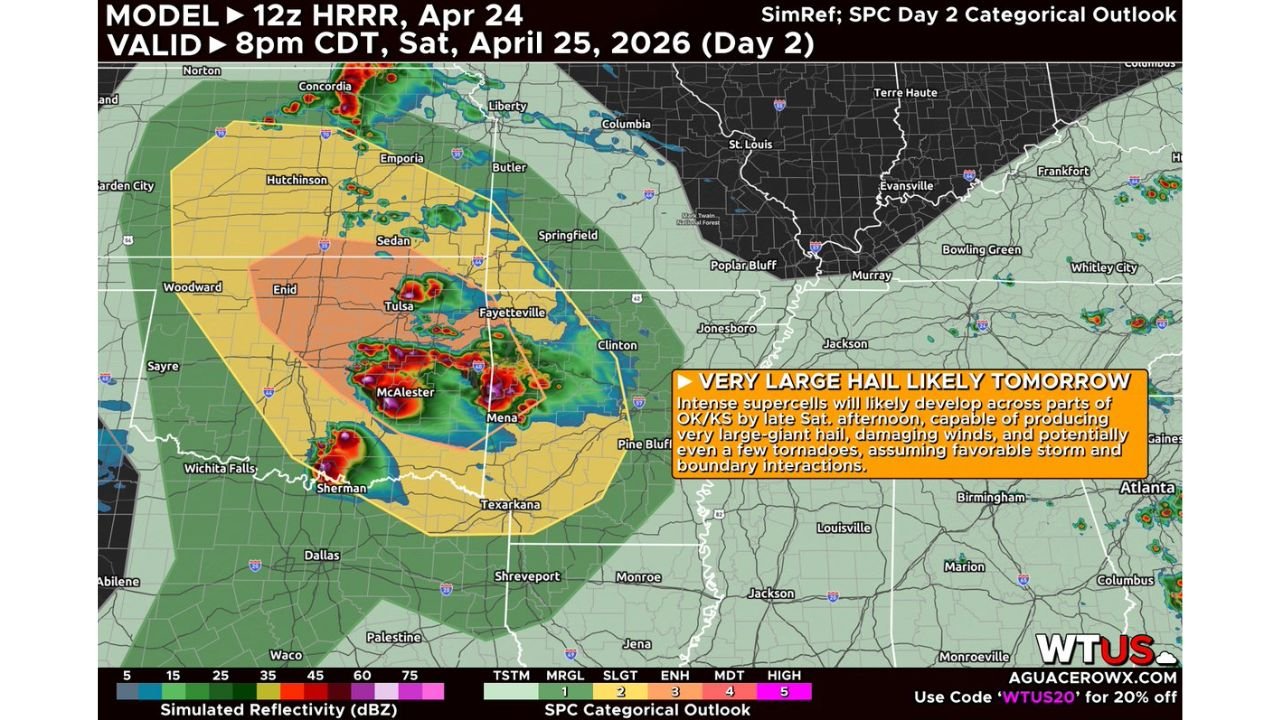
The HRRR model simulation valid Saturday at 8 PM shows the most intense storm cores clustered over Tulsa, McAlester, Enid, and the Oklahoma-Arkansas border region, with the Enhanced Risk zone covering exactly this corridor.
Where the Biggest Hail Is Most Likely
The Enhanced Risk orange zone on Saturday’s categorical outlook covers the corridor most likely to see the most intense supercells. Looking at the cities inside or adjacent to this zone gives a clear picture of Saturday’s hail threat geography.
Oklahoma takes the direct hit with Tulsa, Enid, McAlester, and the northeastern corner of the state sitting inside the Enhanced Risk core. These communities face the highest probability of 2 to 3 inch hail from the first supercells to develop Saturday afternoon.
Kansas is pulled into the northern edge of the Enhanced zone with Hutchinson, Sedan, Emporia, and communities along the Kansas-Oklahoma border inside the threat corridor.
Arkansas has Fayetteville, Mena, and the western portions of the state inside the Slight Risk zone where very large hail and damaging winds are possible as storms track east through the evening.
Texas sees the threat along the northern tier with communities near Sherman, Texarkana, and the Red River corridor inside the outer risk zones.
Missouri gets the eastern fringe of the system with Poplar Bluff and communities in the southeastern corner of the state inside the Slight Risk as storms track northeast after dark.
What 3-Inch Hail Actually Does
Three inches is larger than a baseball. At that size, hailstones falling from a mature supercell carry enough force to punch completely through car roofs, shatter tempered glass, and cause structural damage to roofing and siding that requires full replacement rather than repair. A single supercell tracking through a populated area with 3-inch hail leaves a damage path that can stretch for miles and generate thousands of insurance claims in a matter of minutes.
The forecaster language of “very large to potentially giant” reflects genuine uncertainty about whether Saturday’s most intense supercells hit the 2-inch threshold consistently or push into the 3-inch or larger range. Both outcomes are possible within the same storm depending on exactly how strong the updraft becomes and how long hailstones stay suspended in the growth zone.
The Tornado Question and Why Boundaries Matter
Saturday is primarily a hail day, but the tornado question is real and depends heavily on storm and boundary interactions. Friday’s thunderstorms across Texas and Oklahoma are leaving behind outflow boundaries as they dissipate, and those invisible atmospheric boundaries can dramatically change what happens when Saturday’s supercells encounter them.
When a supercell crosses a boundary, it often experiences a sudden increase in low-level rotation because the boundary adds wind shear and vorticity near the ground that the storm immediately ingests. This is the mechanism that can turn a hail-dominant supercell into a tornado producer within minutes of crossing the boundary. It is conditional because boundary positioning is difficult to predict precisely 24 hours in advance, but it is a real enough scenario that forecasters are explicitly flagging it.
The Enhanced Risk designation already accounts for this possibility. If boundary interactions are favorable Saturday afternoon across northeast Oklahoma, what starts as a hail event could briefly become a tornado emergency before the storm mode evolves further.
75 mph Damaging Winds as Storms Go Linear
As individual supercells eventually merge into a more organized line through Saturday evening, damaging straight-line winds become an increasing concern across Arkansas and into Missouri. Wind gusts reaching 75 mph in bowing line segments are capable of the same tree and power line damage as a weak tornado, and they cover far wider swaths of territory than a discrete tornado track. Communities in western Arkansas and southeastern Missouri should watch for the linear wind threat through the evening and overnight hours as the system tracks east.
Getting Ready Before Late Afternoon
Supercell development is expected to begin by late afternoon Saturday, which means the hail and early tornado window opens roughly between 4 and 7 PM across Oklahoma and Kansas. Anyone in those states who needs to be outside during that window should have a clear plan for getting inside quickly.
Vehicles left outside Saturday afternoon across Tulsa, McAlester, Enid, and surrounding communities are at genuine risk of total loss from 3-inch hail. The window to get them covered is this morning and early afternoon.
WaldronNews.com will track Saturday’s supercell development across Oklahoma and Kansas and provide updates as hail reports and storm warnings come in through the afternoon and evening.