
Northeast Texas and Southeast Oklahoma Upgraded to Enhanced Risk Today as 2-Inch Hail and Tornadoes Target Dallas, Shreveport and Little Rock
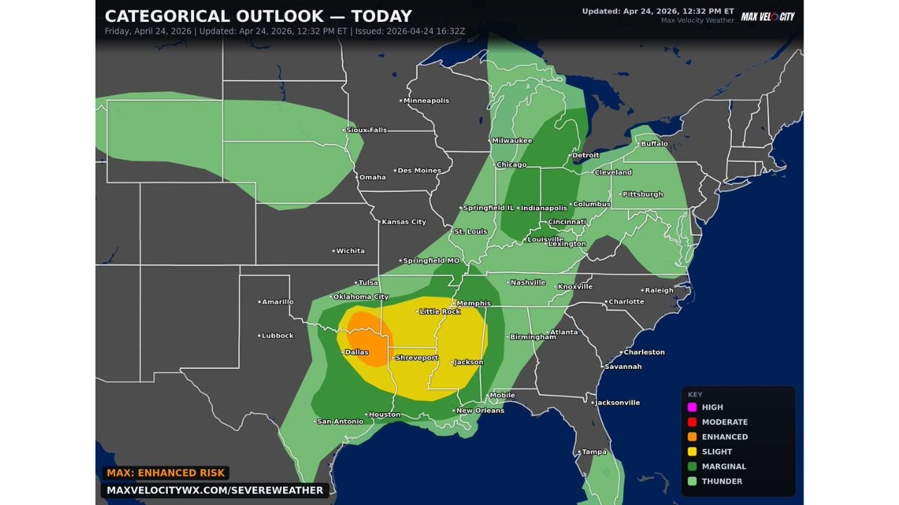
DALLAS, Texas — The Storm Prediction Center has upgraded Northeast Texas and Southeast Oklahoma to an Enhanced Risk (Level 3 of 5) for today, Friday April 24, with the threat centered on supercells capable of producing very large hail measuring 2 inches or larger. Those same supercells will also pose a tornado threat before storms eventually go upscale and damaging winds take over as the primary hazard. Dallas, Shreveport, Little Rock, and Jackson are all inside or adjacent to the highest risk zones on today’s outlook.
The sequence of today’s event matters: tornadoes first while storms are discrete supercells, then a transition to damaging straight-line winds as the line organizes and goes upscale.
The Risk Zone Across Three States
The orange Enhanced Risk core covers Northeast Texas and Southeast Oklahoma, placing the following cities directly in the highest-threat zone:
Texas: Dallas, Shreveport corridor and surrounding northeast Texas counties sit inside or on the edge of the Enhanced zone. The hail threat here is the primary driver of the upgrade, with 2-inch or larger stones expected from the strongest supercells.
Oklahoma: Southeast Oklahoma including the McAlester and Durant area on the northern edge of the Enhanced zone.
The yellow Slight Risk zone extends the threat considerably further, pulling in a large swath of the Mid-South and parts of the Midwest:
Arkansas: Little Rock, Jackson corridor sits inside the Slight Risk zone where all hazards remain possible as storms track east through the afternoon and evening.
Mississippi: Jackson is named directly on the map inside the yellow zone.
Tennessee: Memphis on the northern fringe of the Slight Risk, with Nashville sitting just outside.
Louisiana: New Orleans corridor and southern Louisiana inside the broader threat area.
Illinois, Indiana and Ohio: The green Marginal Risk zone extends surprisingly far north through Springfield IL, Indianapolis, Columbus, Cleveland, Pittsburgh and into Buffalo and Detroit, reflecting a broad general thunderstorm and wind threat as the system pushes northeast later today and tonight.
Hail Leads, Then Wind Takes Over
The storm mode evolution today is what makes the forecast sequence specific and important to understand. Early in the afternoon, storms will fire as discrete supercells in the Enhanced zone. In supercell mode, the primary threats are very large hail and tornadoes, with a few tornadoes possible before the storm structure changes.
As the afternoon progresses and individual storms merge into a more linear arrangement, the storm system goes upscale. At that point the tornado threat drops significantly and damaging straight-line winds become the dominant hazard across a wider area. This upscale transition tends to happen faster in some environments than others, so the window for tornadoes may be relatively brief in some locations while lasting longer in others.
For Dallas and Northeast Texas, being under the Enhanced Risk means the hail and early tornado window is the period that demands the most attention. For Little Rock and Memphis, the system arriving later means they may be dealing more with the wind-dominant, linear phase rather than the discrete supercell phase.
Northeast Texas Has Already Had a Busy Week
Dallas and Northeast Texas are not strangers to severe weather this week. The broader Southern Plains have been active repeatedly since Tuesday, with hail events and wind threats accumulating across the region. Today’s upgrade to Enhanced Risk reflects a genuinely fresh atmospheric setup rather than a continuation of weakening energy. The supercell composite environment across Northeast Texas today has enough instability and shear to support a legitimate significant hail day independent of anything that came before it this week.
The 2-inch hail threshold driving the upgrade is worth putting in perspective. A quarter-sized hailstone is 1 inch. A golf ball is 1.75 inches. Two-inch hail is larger than a hen’s egg and falls fast enough to dent vehicle roofs, break windshields, and cause structural damage to anything left exposed. The strongest supercells today could exceed that threshold.
The Marginal Risk Across the Great Lakes Is Not Nothing
The green Marginal Risk zone reaching Cleveland, Pittsburgh, Columbus, Detroit, and Buffalo represents the eastern and northeastern fringe of today’s system. These cities are not in serious tornado or major hail territory, but damaging wind gusts from squall line segments are possible as the organized system tracks northeast this evening and overnight. Anyone with outdoor events or activities planned in Ohio, Pennsylvania, or western New York this evening should keep an eye on radar.
Residents across Northeast Texas, Southeast Oklahoma, Arkansas, and Mississippi should treat this afternoon as an active severe weather period. Get vehicles covered if possible, stay weather-aware from noon through midnight, and be ready to take shelter quickly if a tornado warning is issued in your county before the storm mode transitions to linear.
WaldronNews.com will continue tracking today’s Enhanced Risk severe weather across Texas, Oklahoma and Arkansas and provide updates as storms develop this afternoon.