
Colorado Could See 2 to 3 Inches of Rainfall Over 7 Days With Late Week Snow Possible as La Nina to El Nino Shift Drives Busiest Spring in Years
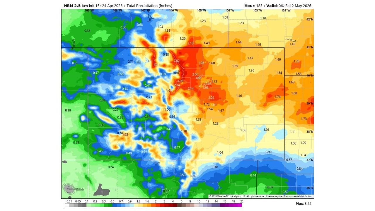
DENVER, Colorado — Seven days of accumulated precipitation models are pointing toward a meaningful wet stretch across Colorado and the Central Rockies through early May, with some areas potentially picking up 2 to 3 inches of total liquid equivalent by Saturday, May 2. The bull’s-eye on the NBM precipitation map sits across north-central Colorado where values reach 2.82 inches, with widespread 1.5 to 2 inch totals covering most of the state. And by late next week, some of that precipitation may fall as snow across the higher elevations and possibly lower terrain.
Before getting into the numbers, three things need to be said clearly. Not all of this falls at once. Some locations will receive significantly more and some significantly less than what the model average shows. And these totals will fluctuate as forecasters get closer to each individual event.
What the 7-Day Map Is Actually Showing
The NBM 2.5km total precipitation map valid through Saturday, May 2 shows the heaviest totals concentrated across north-central Colorado in the 40-41°N latitude band:
North-central Colorado including the Colorado Rockies corridor sees the highest totals on the entire map, with values reaching 2.56 to 2.82 inches in the peak zone. This area receives moisture from multiple storm systems moving through over the seven day period rather than one single event.
The Denver metro and Front Range corridor sits in the 1.70 to 2.06 inch range across this period, which represents a meaningful wet stretch for a region that runs dry in late April most years.
Eastern Colorado into western Kansas shows 1.28 to 1.81 inches, which is significant for an area that depends heavily on spring rainfall for agricultural moisture ahead of the growing season.
Southern Colorado picks up lighter totals of 0.47 to 0.80 inches as storm tracks stay primarily to the north.
Western Colorado shows a highly variable pattern from 0.25 to 1.62 inches depending on elevation and storm track, with the mountain terrain creating sharp local differences in totals.
The Snow Angle Late Next Week
The forecast text mentions a real possibility that some of this precipitation falls as snow by Thursday or Friday of next week. Late April and early May snowfall is not unusual for Colorado at elevation, but this season’s La Nina to El Nino transition has been associated with more active and unpredictable precipitation patterns than typical years. Whether snow reaches lower elevations including Denver depends heavily on storm track and cold air positioning that is still too uncertain to call at this range.
The Bigger Pattern This Fits Into
The forecaster behind this data has been tracking a correlation for months between the rapid La Nina to El Nino transition currently underway and an increase in severe weather and active precipitation events during spring and summer. Looking at April 2026, that correlation appears to be verifying. The Plains and Mid-South have seen back to back severe weather outbreaks, the Midwest absorbed one of its wettest Aprils on record, and now Colorado is looking at a wetter than normal stretch heading into May.
The active pattern is not expected to end in April. There is no reason currently visible in the data to think May will be quieter than April has been across the Central United States.
What Colorado Residents Should Take From This
The 7-day totals shown on this map represent an average of multiple model solutions, which means individual storms within this period still need to be tracked as they approach. A 2.82 inch total over seven days could come from three separate 0.9 inch events spread across the week, or it could come from one larger system surrounded by several smaller ones. The distribution matters as much as the total when it comes to flash flood risk in the Front Range foothills and burn scar areas that remain sensitive to heavy rainfall.
Denver residents should watch the late week period specifically for the snow possibility. Early May snow events in the city are not unprecedented but they do create significant disruption when they occur.
Eastern Colorado farmers should treat the 1.28 to 1.81 inch projected totals as encouraging but not yet bankable. Those numbers will sharpen considerably over the next 48 to 72 hours as individual storm systems come into range.
The wet stretch arriving this week is welcome news for a state that has been monitoring drought conditions carefully through the dry stretch of mid-April. Whether it delivers enough to make a meaningful dent in any moisture deficits depends on how efficiently the storms translate their precipitable water into ground-level rainfall across each individual watershed.
WaldronNews.com will continue tracking Colorado’s 7-day precipitation pattern and provide updates on snow potential and individual storm timing as the week develops.