
Eastern Oklahoma Peak Tornado Window Opens at 5 PM Today With 4 Inch Hail and Strong Tornadoes Expected Before Storms Merge After 8 PM
TULSA, Oklahoma — If you are anywhere in eastern Oklahoma right now, the next three hours are the most dangerous of the day. The peak severe weather window runs from 5 to 8 PM this evening, with powerful supercells producing strong tornadoes, damaging winds, and hail up to 4 inches in diameter before those same storms begin merging into a larger line and shifting primarily to a wind damage threat after 8 PM.
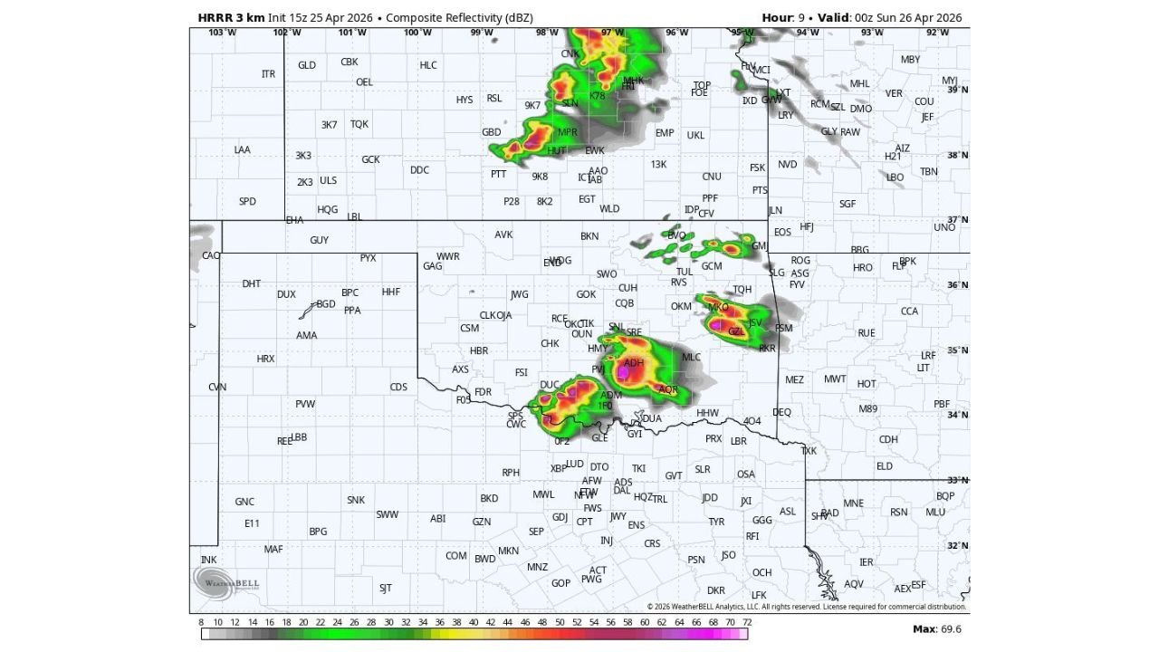
The HRRR radar simulation valid midnight Sunday shows intense storm cores clustered across a wide swath of central and eastern Oklahoma, with the highest reflectivity values concentrated in a corridor running from near Oklahoma City east through Tulsa and into the Arkansas border region.
Where the Storms Are Right Now and Where They Are Heading
The 7 PM simulation shows multiple intense storm cores active across eastern Oklahoma simultaneously. The most prominent clusters are centered in the following areas based on the radar simulation.
The ADH/AOR corridor in east-central Oklahoma shows the deepest and most intense reflectivity on the entire simulation, with values pushing into the purple range above 65 dBZ. This is supercell-level intensity indicating a storm capable of all hazards including very large hail and tornado production.
The OKC/OUN/KTIK area shows a cluster of strong cells over and just southeast of Oklahoma City and Norman with high reflectivity values indicating organized convection.
The Tulsa corridor shows storm activity tracking northeast with cells in the orange and red range across the MKO/TQH region representing the northeastern spread of the severe threat.
A separate cluster is active across south-central Oklahoma near ADM/IFO southeast of Chickasha and Lawton, representing storms that developed along the warm front boundary earlier in the afternoon.
The 5 to 8 PM Window Is Critical Because of What Happens After
The distinction between the supercell phase and the upscale growth phase is not academic tonight. It determines what kind of severe weather threat you face depending on when storms arrive at your location.
During the 5 to 8 PM window, individual supercells are the dominant storm mode across eastern Oklahoma. Supercells maintain organized rotation, have clear access to the warm humid inflow air feeding them from the south, and produce their most concentrated tornado and giant hail threats during this phase. This is the window where a long-track, significant tornado is most possible from any storm that maintains itself as a discrete rotating cell.
After 8 PM, the individual supercells are expected to congeal into a larger convective line. Once that merger happens, the storm system transitions away from the supercell tornado threat and toward widespread damaging straight-line winds. The wind threat from a well-organized line moving through eastern Oklahoma and into Arkansas tonight can still produce widespread structural damage and power outages across hundreds of miles, but the concentrated tornado and giant hail threat of the supercell phase diminishes as organization is lost.
Anyone in eastern Oklahoma tonight is better protected knowing which phase is arriving at their specific location. Western portions of the Tulsa metro and communities west of I-44 are more likely to experience the supercell phase. Communities east of Tulsa toward Muskogee, Tahlequah, and the Arkansas border are more likely to see the system in its transitional or fully linear phase.
Four Inch Hail Is Still Possible During the Supercell Phase
The 4 inch hail forecast has not changed with the timing update. During the 5 to 8 PM supercell phase, any storm maintaining a strong rotating updraft in this environment can produce hailstones in the 3 to 4 inch range. That is larger than a baseball and is capable of catastrophic vehicle and property damage across any community it tracks through.
The ADH/AOR storm cluster southeast of Chickasha is the most intense core on the current simulation and represents the storm most likely to produce the largest hail during the evening hours. Communities in Pontotoc, Coal, Johnston, and Atoka counties are in the path of this cluster.
After 8 PM the Wind Threat Takes Over for Eastern Oklahoma and Arkansas
The transition to a damaging wind threat is not a safer scenario for communities that have not yet been impacted. A squall line with the jet stream overhead producing 70 mph straight-line wind gusts arrives with less warning than a tornado and covers a much wider geographic area. Fort Smith, Fayetteville, and northwest Arkansas communities will see this linear wind threat arriving later tonight as the system tracks east across the state line.
Power outages across eastern Oklahoma and western Arkansas from tonight’s wind event could affect a significant number of customers through Sunday morning.
What to Do Between Now and 8 PM
Take shelter in a sturdy interior room if a tornado warning is issued for your county in eastern Oklahoma during this window. Do not wait to see what the storm looks like from outside. Storms producing 4 inch hail overhead also have tornado potential on their southern flanks and the two threats can arrive at nearly the same time.
Get vehicles under cover immediately if you have not done so. The supercell phase window closing at 8 PM does not give much time for last-minute preparation.
Monitor radar continuously through 8 PM and watch for any tornado warnings issued in your county. After 8 PM, shift your attention to wind warnings as the linear phase takes over.
WaldronNews.com will provide continuous updates on tonight’s severe weather across eastern Oklahoma and into Arkansas as the storm system evolves through the evening.