
Illinois Tornado Outbreak Unfolding Monday as Long-Track Supercells Push From Springfield Through Peoria Toward Chicago and Rockford
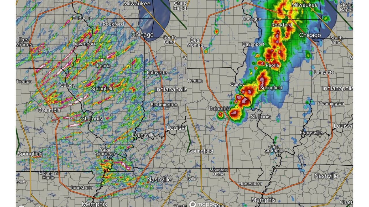
SPRINGFIELD, Illinois — The tornado outbreak that forecasters have been warning about for days across Illinois is now unfolding in real time. Radar shows an organized line of intense storm cores pushing northeast through the heart of Illinois, with the most dangerous activity concentrated in a corridor running from Springfield and Quincy north through Peoria, Rockford, and toward Chicago. A large orange Tornado Watch box covers the entire region.
The rotating updraft track data showing long, consistent paths across multiple counties confirms what forecasters feared most about Monday’s setup: storms are staying discrete long enough to produce long-track, potentially violent tornadoes before eventually merging into a broader system.
What Long Rotating Updraft Tracks Mean for Illinois Tonight
The concept behind Monday’s escalating threat comes down to a specific atmospheric signal that forecasters have been tracking all weekend. When a supercell maintains a long, consistent rotating updraft track across multiple counties rather than quickly merging with neighboring storms, it means the storm has sustained access to warm humid inflow air, the wind shear is efficiently tilting the storm’s updraft into a deep rotating column, and the storm is not being disrupted by outflow from surrounding convection.
Long rotating updraft tracks are the atmospheric signature of the most dangerous kind of supercell. They indicate a storm that is persistent, organized, and efficient at producing tornadoes. A supercell maintaining this structure over central Illinois terrain has miles of flat farmland to travel across with nothing to interrupt its organization.
The radar image showing storm cores moving northeast from Quincy and Columbia, Missouri through St. Louis, Springfield, and up toward Peoria and Rockford is exactly the scenario that was flagged as the high-end outbreak outcome if storms remained isolated during the early evening hours. That scenario appears to be verifying.
The Cities in the Active Storm Corridor Right Now
The radar shows the most intense cores currently positioned across the following areas inside the orange watch box.
Quincy and western Illinois show the southernmost intense cores along the Missouri-Illinois border, with deep red and purple reflectivity values indicating mature supercell structure. These storms are entering Illinois from Missouri with their rotation already established.
Springfield sits in the active corridor with storm cores tracking northeast through the area. Springfield is one of the cities with the most direct exposure to the rotating updraft tracks showing on the current data.
Peoria is in the path of the storm corridor tracking from Springfield northeast. The time of arrival at Peoria depends on storm speed but the trajectory is clear on radar.
Rockford and the Chicago southern suburbs are in the northern portion of the watch box. Depending on how long discrete storm structure holds before the system goes fully linear, the tornado threat for communities between Peoria and Rockford is real and approaching.
St. Louis and Columbia, Missouri show active cores on the western edge of the watch box, confirming that the storm system extends well into Missouri alongside the Illinois threat.
Cape Girardeau and Jonesboro, Arkansas are in the southern portion of the watch box where the system is also active.
Chicago Is Inside the Watch Box and Needs to Be Ready
Chicago sitting inside the orange Tornado Watch box on Monday evening is not a routine occurrence. The watch boundary extends to within miles of the city’s southern suburbs. Any discrete supercell that maintains its rotating structure through the Peoria-Bloomington corridor and continues northeast has a track that would take it directly toward the Chicago metro area.
The flat terrain of central Illinois provides no natural barrier to a supercell tracking northeast. A storm that persists from Springfield to Rockford has traveled approximately 130 miles across essentially uninterrupted farmland. There is nothing to stop it from continuing further.
Indianapolis and Louisville are just outside the current watch box boundary on the eastern side. If the system expands eastward as it tracks northeast, these cities could be pulled into the watch area.
What the Transition to a Line Means for the Threat
The critical question for the next few hours is whether the discrete supercells currently producing the long rotating updraft tracks merge into a squall line or continue as individual organized storms. As long as storms stay separated, the tornado threat remains the primary concern. Once they merge, widespread damaging straight-line winds become the dominant hazard across Indiana, Kentucky, and Tennessee through the overnight hours.
Communities in the active corridor right now should be treating every tornado warning as an immediate life-threatening emergency. The storms producing the current watch are capable of long-track violent tornadoes, and the lead time between a warning and a tornado in a fast-moving supercell can be very short.
If You Are in Central or Northern Illinois Tonight
This is not the time to watch from a window or monitor social media updates. If your county is under a Tornado Warning, move to your interior shelter immediately. First floor, interior room, away from windows, with as many walls between you and the outside as possible.
For Springfield, Peoria, and communities along the active corridor right now: treat the next two hours as the most dangerous period of the evening. For Rockford and the Chicago southern suburbs: the threat is approaching and your shelter plan needs to be in place before storms arrive, not after.
WaldronNews.com is tracking Monday’s Illinois tornado outbreak in real time and will provide updates as storm warnings are issued and the system moves northeast through the state.