
Oklahoma, Arkansas, Louisiana and Texas Border Region Soaked by Active Thunderstorms as New Low Pressure Shifts Heavy Rain North Into the Plains and Midwest Through Monday
OKLAHOMA CITY, Oklahoma — A two-phase severe weather and heavy rainfall event is unfolding across a wide swath of the central United States this weekend, with active thunderstorms and heavy rainfall currently hammering the Oklahoma-Arkansas-Louisiana-Texas border region through Sunday before a developing low pressure system shifts the entire thunderstorm and heavy rain threat northward into the northern Plains and Midwest through Monday.
The Current Threat — OK-AR-LA-TX Border Under Active Thunderstorms
The immediate danger zone spans the four-state border region where Oklahoma, Arkansas, Louisiana and Texas converge. This area is currently under a Heavy Rain and Flash Flooding Possible designation, with Severe Thunderstorms Possible overlapping the same corridor. The weather pattern driving this activity is a stalled frontal boundary interacting with deep Gulf moisture, producing training thunderstorm cells capable of dropping rainfall faster than the ground can absorb it.
Key conditions active right now:
- Heavy Rain and Flash Flooding risk across the OK-AR-LA-TX border zone
- Severe thunderstorms possible within the same footprint
- Active low pressure centers tracking through Oklahoma and into Arkansas
- Frontal boundaries providing continuous lift for storm development through Sunday night
The 72-Hour Rainfall Picture — Sunday Through Wednesday
The 72-hour QPF valid from 00Z Sunday April 26 through 00Z Wednesday April 29 shows a pronounced and large-scale rainfall footprint stretching from the southern Plains through the Great Lakes. The heaviest totals, shown in purple and pink shading on the WPC forecast, are concentrated across a corridor running from Iowa and Illinois northward into Wisconsin and Michigan, with values in several areas exceeding 4.00 to 7.00 inches over the three-day period. A secondary heavy rainfall axis pushes into the Mid-Atlantic and Southeast coast, where dark red shading indicates the highest totals on the entire map.
Rainfall totals by zone across the 72-hour period:
- Iowa, Illinois, Wisconsin, Michigan — 4.00 to 7.00+ inches in the highest-end corridor
- Oklahoma, Arkansas, Missouri — 1.00 to 3.00 inches from the ongoing southern system
- Mid-Atlantic and Southeast Coast — 7.00 to 15.00+ inches in the coastal maximum zone
- Northern Plains and Upper Midwest — 0.50 to 2.00 inches as the system shifts north Monday
How the Pattern Shifts — The Low Pressure Takes Over Monday
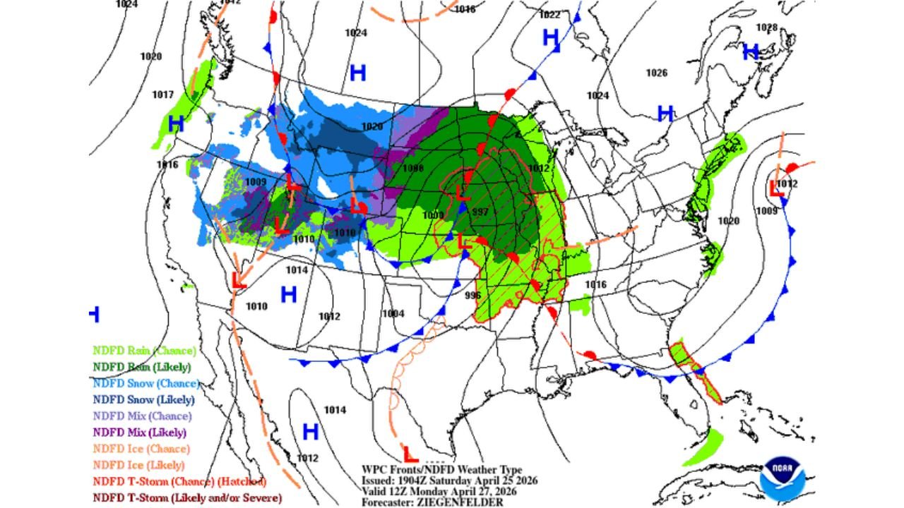
The WPC Fronts and NDFD Weather Type forecast valid Monday April 27 at 12Z shows the mechanism behind the northward shift clearly. A deepening low pressure center — dropping to 996 millibars at its core — is positioned over the central Plains by Monday, dragging the entire moisture and instability axis with it. The frontal system attached to this low stretches from the northern Plains southward through the central Midwest, with the warm sector ahead of the cold front pulling Gulf moisture north into Iowa, Illinois and the Great Lakes states.
The Monday pattern setup:
- 996 mb low pressure center over the central Plains driving the system north
- Likely thunderstorms across the warm sector from Iowa through Illinois and into Indiana
- Likely rain across a broad shield from the Dakotas through the Great Lakes
- Snow possible across the northern fringe of the system into Montana and Wyoming
- Cold front trailing southwestward, keeping severe potential elevated in the warm sector through Monday afternoon
Day 3 Excessive Rainfall Outlook — Illinois and Wisconsin in the Crosshairs
The Day 3 Excessive Rainfall Outlook valid Monday April 27 at 12Z through Tuesday April 28 at 12Z isolates the most serious flash flood risk of the entire event. The Marginal Risk (MRGL) zone — meaning at least a 5% probability of rainfall exceeding flash flood guidance within 25 miles of any point — covers a broad area from southern Illinois northward through Wisconsin. Nested inside that is a Slight Risk (SLGT) zone — at least a 15% probability — centered over northern Illinois and southern Wisconsin, including the greater Chicago metropolitan area.
Excessive rainfall risk breakdown for Monday:
- Slight Risk (SLGT — at least 15% probability): Northern Illinois, southern Wisconsin, Chicago metro area
- Marginal Risk (MRGL — at least 5% probability): Southern Illinois, central Wisconsin, portions of Indiana and Michigan
This is a focused, high-confidence flash flood signal for a heavily populated corridor. Urban areas across Chicago, Rockford, Madison and Milwaukee sit within or adjacent to the Slight Risk zone, where impervious surfaces dramatically accelerate runoff when rainfall rates exceed one inch per hour.
Cities and States in the Risk Zone
Sunday active threat:
- Texarkana, Texas and Arkansas
- Shreveport, Louisiana
- Fort Smith, Arkansas
- Tulsa, Oklahoma
- Little Rock, Arkansas
Monday northward shift:
- Chicago, Illinois
- Rockford, Illinois
- Madison, Wisconsin
- Milwaukee, Wisconsin
- Des Moines, Iowa
- Indianapolis, Indiana
What to Watch Through the Weekend and Into Monday
- Flash flood warnings may be issued with little notice across the OK-AR-LA-TX border region through Sunday night — avoid low-water crossings and do not drive through flooded roadways
- Watch for the low pressure center to deepen rapidly Sunday night into Monday morning, which would accelerate the northward shift of the heaviest rain
- Chicago and Milwaukee residents should monitor rainfall rates Monday afternoon, as the Slight Risk flash flood designation is a meaningful signal for urban flooding
- The cold front passage timing Monday evening will determine whether severe thunderstorm potential lingers into the overnight hours across Illinois and Indiana
- Any area that receives 2 or more inches in under 3 hours Monday should expect flash flood conditions regardless of whether a formal warning has been issued
WaldronNews.com will continue tracking this two-phase event through Monday and provide updates on flash flood warnings, severe thunderstorm potential and rainfall totals as the low pressure system evolves.