
Illinois and Indiana Severe Weather Outbreak Fueled by Deep 850mb Moisture and 40-45 Knot Wind Belt as Jet Stream Shifts Into Right Entrance Region This Afternoon
SPRINGFIELD, Illinois — The atmospheric state across the Midwest severe weather corridor is coming into sharper focus Saturday afternoon, and the ingredients assembling across Illinois and Indiana deserve a careful read. The risk zone currently sits in the right exit region of the upper-level jet stream — a position that suppresses storm development — but that is changing. The pattern is expected to shift into the right entrance region later this afternoon, the configuration that dramatically enhances lift and severe weather potential across the warm sector.
What the Jet Stream Is Doing — and Why the Timing Matters
The 300mb analysis from the Storm Prediction Center mesoscale data shows the upper-level jet positioned across the northern tier of the risk area, with the blue hatched region indicating wind speeds at or exceeding 60 knots at jet stream level. The risk zone currently sitting in the right exit region explains why storm development has been suppressed through the morning hours — divergence and lift at that position are unfavorable for explosive convective initiation.
The critical shift comes this afternoon. As the jet streak pivots and the risk area moves into the right entrance region, upper-level divergence increases sharply, removing the atmospheric cap more efficiently and allowing surface-based parcels to fire into the unstable warm sector above. This is the moment the severe weather window opens.
Supporting that transition:
- A westerly wind belt of 40-45 knots at 500mb — the mid-level of the atmosphere — is positioned to overspread the warm sector as the pattern evolves
- 500mb height contours show a broad trough amplifying across the central Plains, tightening the pressure gradient and increasing wind shear through the afternoon
- The 500mb temperature field confirms cold air aloft advancing behind the trough, steepening lapse rates and increasing instability across Illinois and Indiana
The Cap That Is Holding — and the EML That Could Break It
The 700mb analysis reveals a more complicated picture beneath the jet. Multiple short waves — small-scale disturbances embedded in the flow — are present across the risk area at 700mb, but they remain relatively weak at this hour. More significantly, an Elevated Mixed Layer (EML) is present with temperatures of 6 to 8 degrees Celsius at this level.
An EML is a layer of warm, dry air that originates over elevated terrain — typically the Rockies or Mexican Plateau — and rides eastward over the cooler, moister air at the surface. It acts as a cap, preventing premature storm development through the morning. That same cap, when it erodes or is undercut by a strengthening surface boundary, can release stored instability explosively. The 6-8°C EML currently in place is strong enough to hold convection in check through mid-morning while simultaneously locking in the moisture and instability building beneath it.
The 700-500mb mean relative humidity field confirms values at or above 70% across a broad zone, indicating the mid-levels are sufficiently moist to support deep, organized convection once initiation occurs.
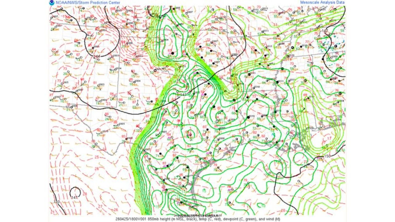
The 850mb Moisture — The Most Impressive Layer in the Atmosphere Today
The 850mb analysis is where the setup becomes genuinely notable. The dewpoint field at 850mb — shown in green contours — displays a tight, concentrated moisture axis pushing northward through the central Plains and into Illinois, with values indicating very deep and rich low-level moisture in place across the warm sector. Southerly flow at 850mb is pulling Gulf moisture directly into the risk zone, maintaining dewpoints that support surface dewpoints in the low-to-mid 70s°F across southern Illinois, Indiana and Kentucky.
This level of low-level moisture is significant for two reasons:
- It provides the fuel for explosive thunderstorm development once the cap erodes — deep moisture means high CAPE (Convective Available Potential Energy) values and intense updrafts capable of supporting large hail, damaging winds and tornado development
- The southerly flow at 850mb creates directional wind shear — winds shifting from southerly at low levels to westerly at mid and upper levels — which is one of the primary ingredients for supercell thunderstorm development and sustained tornado production
Layer-by-Layer Summary of the Atmospheric Setup
- 300mb (jet stream level): 60+ knot jet streak shifting risk area from right exit suppression into right entrance enhancement this afternoon
- 500mb (mid-level): 40-45 knot westerly wind belt overspreading the warm sector, trough amplifying and increasing shear
- 700mb (lower-middle atmosphere): Weak short waves present, EML at 6-8°C capping development but primed to release, 700-500mb humidity at or above 70%
- 850mb (low-level): Very rich, deep moisture in place, strong southerly flow maintaining Gulf moisture transport directly into the Illinois and Indiana warm sector
What Changes This Afternoon
The transition from right exit to right entrance region positioning is the key unlock for this event. Once that shift occurs:
- Upper-level divergence increases, pulling air upward more aggressively from the surface
- The EML cap begins to erode along and ahead of the advancing cold front and dryline
- Surface-based CAPE — suppressed through the morning — becomes accessible to thunderstorm updrafts
- Discrete supercell development becomes possible across the warm sector from southern Illinois northward through Indiana
Residents across Chicago, Springfield, Peoria, Indianapolis and Evansville should treat the afternoon hours as the highest-risk window and have storm shelter plans finalized before noon.
What to Watch Through the Afternoon
- Right entrance region timing — any meteorologist referencing jet positioning moving favorable this afternoon is confirming the window is opening
- Surface dewpoints at or above 70°F across southern Illinois and Indiana are the moisture confirmation signal
- EML erosion along the front — the cap breaking cleanly along a discrete boundary produces the most dangerous supercell environment; a messy, widespread cap break produces a less organized severe weather mode
- Storm mode at initiation — discrete supercells are the tornado producers; if storms immediately congeal into a line, the tornado threat decreases but the damaging wind threat remains significant
- 850mb southerly flow maintaining through the afternoon keeps the moisture pipeline open and supports sustained severe weather well into the evening hours
WaldronNews.com will continue tracking atmospheric evolution across Illinois and Indiana through Monday and provide updates on cap erosion timing, storm initiation and severe weather warnings as the outbreak develops.