
Alabama Faces Multiple Storm Rounds This Week With Strong Winds and Isolated Tornadoes Possible From Huntsville to Birmingham
BIRMINGHAM, Alabama — An unsettled and potentially dangerous week is taking shape across Alabama, with multiple rounds of showers and thunderstorms expected to push through the state from Monday night through at least Thursday. The northern half of Alabama carries the heaviest rainfall burden — 2 to 3 inches total through Sunday May 3 — while South Alabama sees 1 to 2 inches. The storms are not just a rain event. Strong winds are the primary concern in the first round, with a brief isolated tornado possible, and a second, potentially more significant severe weather round arrives Tuesday night into Wednesday morning.
Monday Night — The First Round Arrives After Midnight
The initial severe weather round is a late-night system. Storms are expected to develop mostly after midnight Monday night, meaning the threat window is centered in the overnight hours when most residents are asleep and reaction time to warnings is reduced. The Severe Weather Outlook for Monday April 27 shows the northwestern corner of Alabama — including Florence, Huntsville and Decatur — sitting inside a Level 2 Slight Risk zone, with a Level 1 Marginal Risk covering Birmingham, Tuscaloosa and Gadsden southward.
What this round brings:
- Primary threat: Strong damaging winds — the most likely severe weather hazard with this system
- Secondary threat: Brief isolated tornado — cannot be ruled out, particularly across the Slight Risk zone in northern Alabama
- Timing: Mostly after midnight — overnight tornado warnings require advance shelter planning before bedtime Monday
Residents across Florence, Huntsville, Decatur and the Tennessee Valley face the highest exposure in this first round and should identify a safe interior room on the lowest floor of a sturdy structure before going to sleep Monday night.
Tuesday Night Into Wednesday — The More Uncertain and Potentially Larger Threat
The second round of storms arrives Tuesday night into Wednesday morning and carries a meaningfully different risk profile. While the Monday night round has a relatively well-defined threat type, the Tuesday night system is less certain — and that uncertainty cuts in both directions. Forecasters are explicit that it is too early to know the magnitude of the threat, and whether a tornado threat will develop remains an open question at this stage.
The Severe Weather Outlook for Tuesday April 28 shows a substantial upgrade from Monday’s picture. The risk zone expands significantly:
- Level 2 Slight Risk now covers the full northern tier of Alabama including Florence, Huntsville, Decatur, Gadsden, Birmingham and Tuscaloosa
- Level 1 Marginal Risk extends southward through Montgomery, Auburn and Talladega
- The risk footprint is larger, the uncertainty is higher, and the severe weather potential — if the atmosphere cooperates — is greater than the Monday night round
Forecasters have stated that once early Tuesday morning storms clear, the picture for Tuesday night will come into much sharper focus. That update window is the most important forecast moment of the week for Alabama residents.
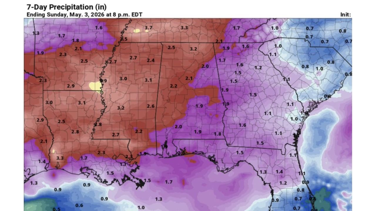
The 7-Day Rainfall Totals — Northern Alabama Bears the Brunt
The 7-day precipitation forecast ending Sunday May 3 at 8 PM EDT shows the full weekly rainfall footprint across the region. Alabama sits at the eastern edge of a broad, deep red precipitation zone centered over Arkansas, Mississippi and Tennessee, where totals reach 2.5 to 3.2 inches across the northern counties. The gradient across the state is clear:
- Northern Alabama (Florence, Huntsville, Decatur, Gadsden corridor) — 2.0 to 2.5 inches through May 3
- Central Alabama (Birmingham, Tuscaloosa, Talladega) — 1.9 to 2.2 inches
- South Alabama (Montgomery, Dothan, Mobile corridor) — 1.5 to 1.9 inches
- Coastal Alabama and Mobile — 1.3 to 1.7 inches
These are beneficial rainfall totals for a state that has seen drought conditions develop across portions of the region this spring. The agricultural and soil moisture value of 2 to 3 inches across northern Alabama is real and meaningful. The complication is that beneficial rain and dangerous storms arrive in the same package this week.
The Weekly Pattern — Day by Day
- Monday night after midnight: First storm round, strong winds primary threat, isolated tornado possible, Slight Risk across the Tennessee Valley
- Tuesday night into Wednesday morning: Second and potentially larger storm round, severity still uncertain, Slight Risk expanding to cover most of northern and central Alabama
- Thursday: Some rain possible across South Alabama only — lighter and less organized than the earlier rounds
- Friday: Mostly rain-free at this point in the forecast
Cities and Risk Zones This Week
Slight Risk Monday night:
- Florence, Alabama
- Huntsville, Alabama
- Decatur, Alabama
Slight Risk Tuesday night (expanded zone):
- Florence, Alabama
- Huntsville, Alabama
- Decatur, Alabama
- Gadsden, Alabama
- Birmingham, Alabama
- Tuscaloosa, Alabama
Marginal Risk Tuesday night:
- Montgomery, Alabama
- Auburn, Alabama
- Talladega, Alabama
- Greenville, Alabama
- Troy, Alabama
What Alabama Residents Need to Do Before Monday Night
- Do not wait until Tuesday to make a shelter plan — the Monday overnight round requires action before bedtime Monday, not Wednesday
- Residents in mobile homes and manufactured housing across the Tennessee Valley should identify a permanent structure shelter now, as overnight tornado warnings leave no time to travel
- Charge all devices and ensure weather alert notifications are active on every phone in the household — overnight severe weather is significantly more dangerous when warnings go unheard
- Watch for the Tuesday morning forecast update — once early Tuesday storms clear, forecasters will have a much clearer read on Tuesday night severity and tornado potential
- Thursday rain across South Alabama is the lighter, lower-concern end of this week’s pattern — the dangerous days are Monday night and Tuesday night
WaldronNews.com will continue tracking Alabama’s multi-round severe weather week and provide updates on Tuesday night tornado potential and storm totals as the pattern evolves.