
Illinois Faces Intense Numerous Storms Monday Through Monday Night With Strong Tornadoes Expected Regardless of Morning Convection
SPRINGFIELD, Illinois — A severe weather outbreak is expected across portions of the Midwest from Monday through Monday night, and forecasters are leaving little room for optimism about the outcome. Morning convection is the only failure mode with this setup — and even that caveat comes with a qualifier. If a warm front lifts north faster than expected in the morning, rapid destabilization will occur ahead of schedule and the outbreak intensifies further. Either way, strong tornadoes are expected.
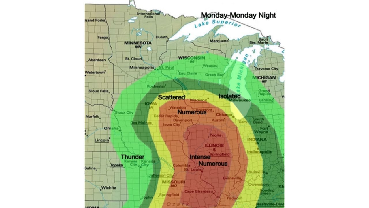
The Storm Coverage Map — What Each Zone Faces
The outlook graphic for Monday through Monday night lays out storm coverage expectations by region with striking clarity, and the language used for Illinois is among the most serious on the entire map:
- Illinois — Intense Numerous — the highest storm coverage and intensity designation on the map, centered over Springfield, Peoria and the broader central Illinois corridor extending into St. Louis, Missouri and Cape Girardeau
- Iowa — Numerous — covering Cedar Rapids, Davenport, Iowa City and Waterloo with a high storm count through the period
- Wisconsin and northern Illinois — Scattered — Madison, Rockford and the areas north see a lower storm count but remain inside the risk zone
- Milwaukee and Lake Michigan corridor — Isolated — the eastern fringe of the outbreak, with fewer storms but not zero threat
- Kansas, Missouri border — Thunder — the outer western edge of the system, with general thunderstorm activity across Topeka, Kansas City and Jefferson City
The step from Numerous to Intense Numerous is significant. It signals not just a high storm count but storms that are expected to be organized, persistent and capable of all severe hazards throughout the period rather than brief, isolated events.
The Only Failure Mode — Morning Convection
Forecasters have narrowed the list of things that could limit this outbreak to a single item: morning convection. If storm clusters push through central Illinois in the morning hours and leave behind a stabilized, cloud-covered atmosphere, the afternoon severe weather window shrinks or closes for that portion of the state. This is the washout scenario that has appeared across multiple forecast discussions.
But there is a counter to that scenario built directly into the forecast. If the warm front — the boundary between cold air to the north and warm, moist Gulf air to the south — lifts northward faster than expected through the morning hours, it pulls the unstable air mass northward more quickly, allowing rapid destabilization to occur across the risk zone even after morning storm activity. A faster warm front lift essentially resets the atmosphere and reopens the severe weather window with less delay than a slow lift would allow.
The bottom line from forecasters: either way, strong tornadoes are expected. The morning convection scenario does not eliminate the tornado threat — it shifts and potentially reduces it. The fast warm front lift scenario amplifies it.
Why Illinois Is in the Intense Numerous Category
The Intense Numerous designation for Illinois reflects the atmospheric setup that has been building across the state through the weekend:
- Deep Gulf moisture at 850mb feeding directly into the Illinois warm sector through southerly low-level flow
- Strong deep-layer shear supporting long-tracked, organized supercells before storm upscale growth
- Steep lapse rates driving explosive updraft development once convection initiates
- A well-defined frontal boundary providing the focus for repeated storm development through the afternoon and evening rather than a single round
- The warm front position across northern Illinois creating a zone where the atmosphere transitions rapidly from stable to extremely unstable over a short distance — the ideal setup for discrete, rotating supercells
Cities Inside the Intense Numerous Zone
- Springfield, Illinois
- Peoria, Illinois
- Bloomington, Illinois
- Decatur, Illinois
- Champaign, Illinois
- St. Louis, Missouri
- Cape Girardeau, Missouri
- Evansville, Indiana
- Paducah, Kentucky
Cities in the Numerous Zone
- Cedar Rapids, Iowa
- Davenport, Iowa
- Iowa City, Iowa
- Waterloo, Iowa
- Des Moines, Iowa
- Chicago, Illinois
- Rockford, Illinois
What to Do Before Monday Morning
- Central Illinois residents should treat this as a confirmed outbreak, not a possibility — the Intense Numerous designation combined with the strong tornadoes expected language from forecasters leaves very little uncertainty about the severity of what is coming
- Identify and physically walk to your tornado shelter location today — basement, interior room on lowest floor, away from all windows
- Mobile home residents across the Springfield-Peoria-Champaign corridor must arrange to stay in a permanent structure Monday night — there is no safe option inside a mobile home when strong tornadoes are expected
- Watch for warm front position updates Monday morning — a faster northward lift is the signal that the outbreak is escalating, not diminishing
- The threat runs through Monday night, meaning shelter plans must account for overnight hours when warnings may arrive while residents are asleep
WaldronNews.com will continue tracking Monday’s severe weather outbreak across Illinois and the broader Midwest and provide real-time updates on tornado warnings, storm reports and outbreak progression through the night.