
Northern Illinois Storm Clusters Through Midday Monday May Dampen Late Day Severe Weather as Atmosphere Race to Recharge Before Evening
CHICAGO, Illinois — The big caveat hanging over Monday’s severe weather setup across Illinois is becoming clearer with the latest forecast modeling, and it centers entirely on northern Illinois through midday. Non-severe storm clusters are likely to push through the northern third of the state through noon Monday, and whether those storms clear in time for the atmosphere to recharge through afternoon warmth will determine how significant the late day and evening severe weather threat actually becomes.
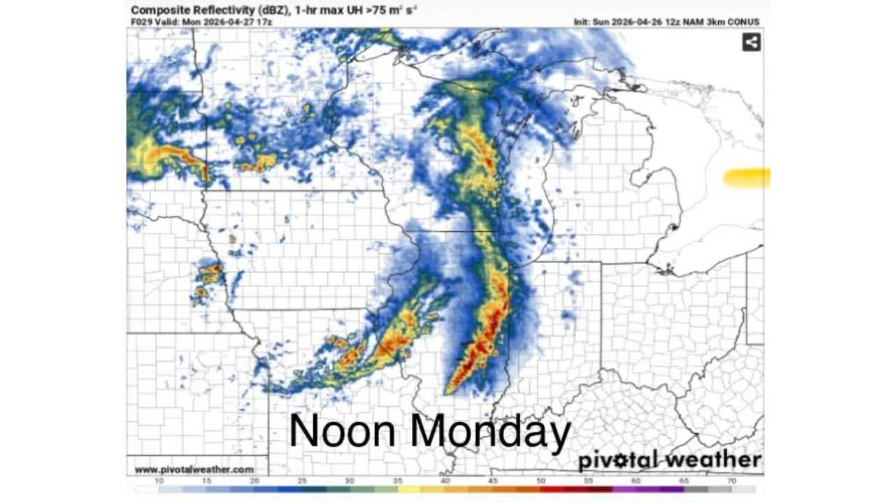
What the Noon Monday Radar Forecast Shows
The NAM 3km composite reflectivity forecast valid Monday April 27 at 17Z — noon local time — shows the storm situation across Illinois at the critical midday decision point. A broad swath of blue and green radar returns covers much of northern Illinois, with the more intense red and orange cores concentrated along a southwest-to-northeast oriented line pushing through the central portion of the state. The UH (Updraft Helicity) markers on the forecast — indicated by the dots tracking along the storm line — identify where rotating updrafts are most probable, with the signal strongest along the central and southern portions of the line rather than the northern clusters.
The northern storm activity visible at noon is the damper forecasters are concerned about. These storms crossing northern Illinois through midday are not expected to be severe themselves, but they leave behind cloud cover, outflow boundaries and a partially stabilized atmosphere that takes time to recover once they clear.
The Recharge Question — Everything Hinges on Midday Clearing
The atmosphere’s ability to fuel dangerous late afternoon and evening storms comes down to one variable: how quickly northern Illinois clears after the midday storm clusters exit. The mechanism is straightforward:
- Morning and midday storms consume surface-based instability and leave clouds behind
- Clouds block solar radiation, preventing surface temperatures from rising
- Without surface heating, CAPE — Convective Available Potential Energy, the fuel for thunderstorm development — cannot recover to dangerous levels
- If clearing happens fast enough after noon, afternoon sunshine rapidly reloads the atmosphere
- If clearing is slow or incomplete, the evening storm round fires into a partially depleted environment
Forecasters are explicit: a lot will hinge on when storms clear after midday and whether the atmosphere has enough time in the remaining afternoon hours to recharge before the main severe weather window opens.
The Eastern Plains Connection — Why Today’s Storm Activity Matters
The forecast is not just about what happens over Illinois. The evolution of storms across the eastern Plains on Sunday directly feeds into Monday’s Illinois setup. The connection works like this:
- Active storm clusters over the eastern Plains Sunday afternoon and evening are very probable
- Those clusters will track eastward overnight, arriving over the northern third of Illinois weakened through Monday morning and midday
- As they cross northern Illinois in a weakened state, they suppress the atmosphere beneath them
- They then strengthen again as they reach Indiana and turn to the southeast — meaning Indiana could see a more vigorous storm mode than northern Illinois during the early afternoon
This is why some forecast models are trending toward sliding the Enhanced Risk zone southward away from northeastern Illinois in future outlooks. The northern suppression from these weakened but persistent storm clusters is real, and the modeling is beginning to reflect it.
What This Means for the Risk Zone
The practical implication of this data is a geographic shift in the highest risk:
- Northern Illinois — midday storm coverage is the damper; late day severe potential depends entirely on how fast the atmosphere recovers after noon clearing
- Central Illinois — less exposure to the morning cluster suppression, better positioned for afternoon atmospheric recovery and the strongest late day severe weather
- Southern Illinois — furthest from the northern cluster impacts, most likely to see the cleanest severe weather environment through the afternoon and evening
- Indiana — storm clusters strengthening as they push east and turn southeast means Indiana enters the picture as a significant player for afternoon severe weather
What to Watch Monday Morning Into Noon
- Radar coverage across northern Illinois at 10 AM — widespread ongoing rain and storms at this hour means the recharge window is shrinking
- Sky conditions at noon — sunshine returning to Chicago, Rockford and the northern Illinois corridor by noon is the most favorable signal for a significant afternoon severe weather event statewide
- Enhanced Risk zone position in any updated outlooks — if the orange Enhanced Risk zone slides south away from northeastern Illinois as forecasters suspect it might, central and southern Illinois residents should treat that as a direct escalation of their local threat
- Storm mode in Indiana by early afternoon — strengthening clusters crossing into Indiana and turning southeast confirm the eastern track forecasters are modeling and signal that the severe weather axis is shifting eastward
WaldronNews.com will continue tracking Monday’s evolving storm setup across Illinois and Indiana and provide updates on midday clearing trends, risk zone shifts and severe weather initiation timing through the afternoon.